
>>> YOUR DAILY CELESTIALS <<<
STAR:
–OUR STAR ROSE AT: 6:13am this morning
–OUR STAR WILL SET AT: 7:27pm this evening
–TOTAL DAYLIGHT TIME: 13 hours and 14 minutes
MOON:
–OUR MOON WILL RISE AT 7:41pm this evening
–MOON RISE DIRECTION: East-Southeast
–OUR MOON WILL SET AT: 6:39am tomorrow morning
–MOON SET DIRECTION: West-Southwest
–MOON PHASE: *FULL BLUE MOON* (99.3%)
~~~~~~~~~~~~~~~~~~~~~~
>>> DAVE’S WEEKLY WEATHER NUTSHELL <<<
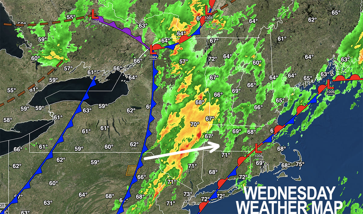
–A thunderstorm complex is pushing east-northeast into the Berkshires this morning
–Some cells may be strong with torrential rain, frequent lightning, and winds gusting to 40mph
–This line sweeps the greater WMass region from 7am through 11am to noon
–Highs reach the mid to upper 70s as sun breaks out this afternoon behind the cold front
–Temps and humidity then tumble tonight with lows dropping into the upper 40s to mid 50s with clearing skies and northwest wind gusts 20-30mph
–Thursday is a total taste of Fall with highs in the low 60s to low 70s under sunny skies, and a breezy morning
–Wind slacken by afternoon, sunshine dominates, then we’re clear, calm, and dry which helps drop lows to the low to mid 40s into Friday morning
–Friday through Labor Day Monday we are in a warming trend, drier at first, more muggy by Monday, with very warm to borderline hot temps by middle of next week as we hit a multi-day fair weather streak, but before we talk details let’s check a note from our local and delicious sponsor, #TandemBagelCo, with their newest location in the Stop & Shop Plaza on King Street in Northampton, MA.
~~~~~~~~~~~~~~~~~~~~~~
>>> A NOTE FROM OUR SPONSOR <<<
Dave Hayes The Weather Nut is Sponsored by Individual Community Members, Patrons & Tandem Bagel Company… No matter the weather, Tandem Bagel is always there for you at several valley locations to make your mornings brighter! With bagels baked fresh daily (including Gluten-Free options), house-whipped cream cheese, coffee, and tons of lunch options, Tandem is the perfect quick stop for lunch, breakfast, or a coffee and bagel to go. Find them in Easthampton, Northampton, Hadley, Florence, and West Springfield, or use their super-streamlined online ordering tool by visiting their website.
>>> MORNING DISCUSSION <<<
Good morning everybody, we have an incoming cold front that is pushing showers, downpours and thunderstorms into the Berkshires and Litchfield Hills at 7am.
Torrential rain may produce some isolated areas of street flooding, and a couple of these cells look strong, so don’t be surprised if some wind kicks up with these, but overall instability is lower so severe morning storms are not expected at the moment, but I will monitor.
This line will sweep the greater WMass region with showers, downpours and thunderstorms through late morning to noon, and then keep tracking east-northeast and out of here.
This will allow skies to break up and produce at least partial sunshine by early to mid afternoon, and this should help highs crest well into the 70s to near 80º before colder air works in behind the front.
Northwest winds pick up this evening and overnight, gusting 15-30mph at times as colder, drier air works into the region with lows in the upper 40s to mid 50s.
Northerly winds gusting to 25mph will abate at some point around or before noon Thursday, and we’ll then enjoy a gorgeous Autumnal day with highs in the 60s to low 70s with calm, sunny conditions.
Radiational cooling will then set up shop over the region tomorrow night as calm wind, dry air, and clear skies combine to help radiate heat out into Space and drop lows into the 40s for most, with some low 40s possible in far northwest MA and SVT.
Friday looks beautiful with highs in the upper 60s to mid 70s under sunny skies and lows in the low 50s under clear skies.
A parade of fair weather continues through Labor Day Weekend with sunshine and warming temps as high pressure tracks east of us, putting us into a southerly flow as we move through the weekend.
Saturday highs will be in the 70s to near 80º, but Sunday and Monday highs are climbing into the low to mid 80s and mid to upper 80s respectively under sunny skies!!
A superb end-of-summer holiday weekend is on the way!
This very warm to borderline hot weather with increased humidity lasts until mid to late week by which time another frontal boundary may bring showers.
Enjoy the upcoming tastes of Fall AND Summah!!
And pack an umbrella this morning… Have a great day!
>>> BE KIND <<<
“Hello babies. Welcome to Earth. It’s hot in the summer and cold in the winter. It’s round and wet and crowded. On the outside, babies, you’ve got a hundred years here. There’s only one rule that I know of, babies: Goddamn it, you’ve got to be kind.”
–Kurt Vonnegut