
>>> YOUR DAILY CELESTIALS <<<
STAR:
–OUR STAR ROSE AT: 6:12am this morning
–OUR STAR WILL SET AT: 7:29pm this evening
–TOTAL DAYLIGHT TIME: 13 hours and 17 minutes
MOON:
–OUR MOON WILL RISE AT 7:10pm this evening
–MOON RISE DIRECTION: East-Southeast
–OUR MOON WILL SET AT: 5:16am tomorrow morning
–MOON SET DIRECTION: West-Southwest
–MOON PHASE: Waxing Gibbous (95.9%)
~~~~~~~~~~~~~~~~~~~~~~
>>> DAVE’S WEEKLY WEATHER NUTSHELL <<<
–Patchy fog early lifts, and a multi-cloud layer day will allow for periods of sunshiine, which should be morphing to mostly cloudy late
–Highs well into the 70s with humid conditions, and dewpoints in the 60s
–A few late afternoon or evening light showers are possible mainly south of the Pike
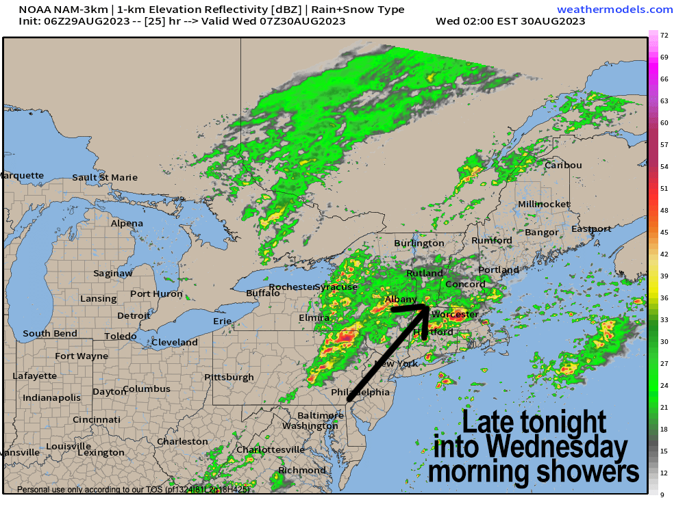
–Showers spread in overnight, and by Wednesday morning many of us will see rain, heavy at times, with lows in the low to mid 60s along with patchy fog
–Rain, heavy at times Wednesday morning, especially along and east of the I-91 corridor lasts until about early afternoon and then lifts northeast and away as the front pushes through
–Highs Wednesday will crest well into the 70s
–And then, the Dryening commences with northwest to northwest flow being ushered in out of Canada
–Drier, cooler, low humidity, lovely air will be blowing and gusting 20-30mph Wednesday night into Thursday morning, dropping lows to the 50-55º range
–Thursday and Friday look lovely with highs in the mid 60s to low 70s Thursday, then low to mid 70s Friday (50s for lows) with sunny skies
–Then Labor Day Weekend looks even better with warming temps through the period, reaching the low to mid 80s by Sunday and Monday under mostly sunny skies
–If this big high pressure “look” continues, we are keeping Hurricane Franklin out to sea, and potentially looking in 5 days of sunny, dry weather, but before we talk details let’s check a note from our local and delicious sponsor, #TandemBagelCo, with their newest location in the Stop & Shop Plaza on King Street in Northampton, MA.
~~~~~~~~~~~~~~~~~~~~~~
>>> A NOTE FROM OUR SPONSOR <<<
Dave Hayes The Weather Nut is Sponsored by Individual Community Members, Patrons & Tandem Bagel Company… No matter the weather, Tandem Bagel is always there for you at several valley locations to make your mornings brighter! With bagels baked fresh daily (including Gluten-Free options), house-whipped cream cheese, coffee, and tons of lunch options, Tandem is the perfect quick stop for lunch, breakfast, or a coffee and bagel to go. Find them in Easthampton, Northampton, Hadley, Florence, and West Springfield, or use their super-streamlined online ordering tool by visiting their website.
>>> MORNING DISCUSSION <<<
Good morning everybody, to start off I just have to say that while we will be moving through some showers tonight and tomorrow and then enjoying a multi-day fair-weather late-summer stretch (that’s a LOT of hyphens, Dave!!!!) I have my stink eye on Hurricane Idalia for the second week of September, and more specifically the weekend after next.
This is because some guidance shows it heading out to sea, but then it gets retrograded back west due next week’s high pressure finally scooting eastward, and pulling back toward south of New England with a trough west of us. This could spell trouble and bring that storm ashore here, and while it’s a VERY VERY LOW probability, I will be monitoring it the whole way.
As for our current weather, the weekly nutshell pretty much describes it, but the bottom line is that we will be seeing northern moisture off of Hurricane Franklin interact with an incoming Great Lakes trough and induce more cloud development today after some periods of sunny breaks, and then more shower development lifting north into our region tonight and tomorrow morning.
Rain will fall heavily at times overnight into Wednesday morning, and some folks could pick up over an inch of rainfall.
Once the rain quits by early afternoon tomorrow, a cold front will sweep through and humidity that crests today, tonight and especially tomorrow morning with dewpoints in the 60s to 70º gets swept out to sea, with much drier air moving in, and with it, northwest gusts of 20-30mph Wednesday night into Thursday morning before abating Thursday afternoon or so.
Thursday and Friday look lovely, dry, low humidity, highs mid 60s to mid 70s, and then Saturday through Monday look dry, but warmer, sunny, highs in the upper 70s to mid 80s.
These temps should continue into the following week for a late-summer taste as the light continues to wane down toward the Autumnal Equinox on September 23rd.
The bottom line is that if we’re lucky, the air mass behind this Wednesday frontal passage will carry enough dry air with it to give us a 5-day stretch of clear weather that many have been craving since we had such conditions in the Spring.
Have a great day!
>>> BE KIND <<<
“Hello babies. Welcome to Earth. It’s hot in the summer and cold in the winter. It’s round and wet and crowded. On the outside, babies, you’ve got a hundred years here. There’s only one rule that I know of, babies: Goddamn it, you’ve got to be kind.”
–Kurt Vonnegut