
>>> YOUR DAILY CELESTIALS <<<
STAR:
--OUR STAR ROSE AT: 5:56am this morning
--OUR STAR WILL SET AT: 7:52pm this evening
--TOTAL DAYLIGHT TIME: 13 hours and 56 minutes
MOON:
--OUR MOON WILL SET AT: 7:30pm this evening
--MOON SET DIRECTION: West-Northwest
--OUR MOON WILL RISE AT: 4:50am tomorrow morning
--MOON RISE DIRECTION: Northeast
--MOON PHASE: Waning Crescent 3.6%)
~~~~~~~~~~~~~~~~~~~~~~
>>> DAVE’S WEEKLY WEATHER NUTSHELL <<<
--A partly to mostly sunny day is on tap to kick off the work week, and highs will reach the 70s to low 80s with light west wind
--Humidity builds this evening as a warm front approaches
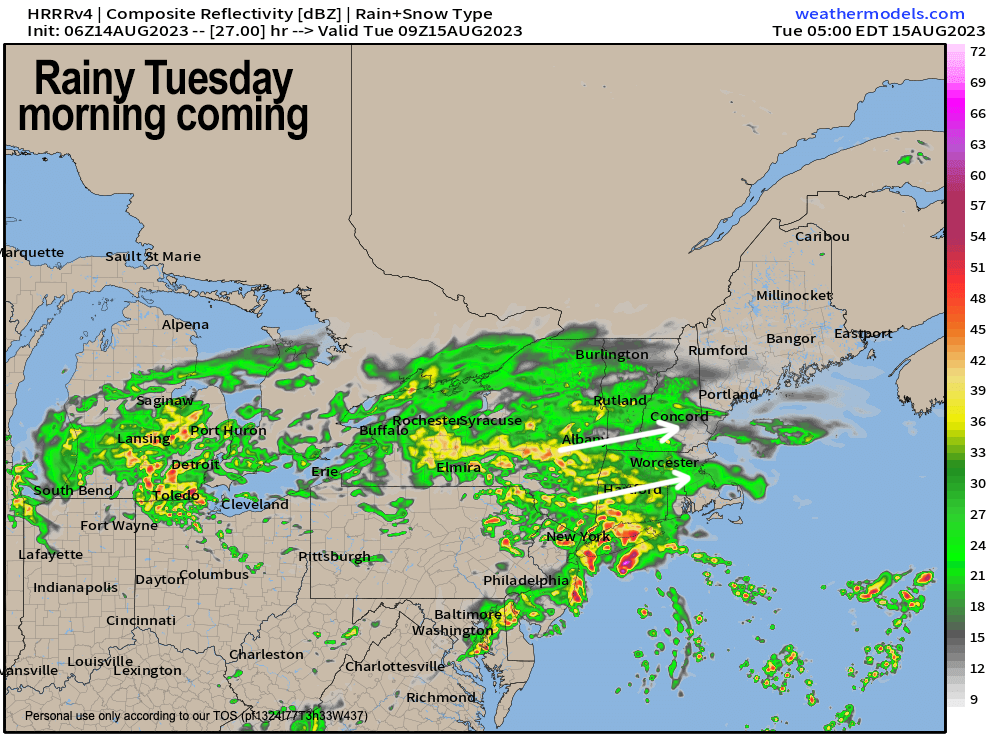
--Showers work into the region mostly around and after midnight
--Some downpours and thunderstorms are possible, and a storm may become strong to severe, especially south of the Pike
--We can't rule out a transient, weak tornado in CT, RI or SE.MA
--Tuesday morning looks quite rainy, with some isolated street flooding possible, so give more time for the morning commute
--Rain tapers to isolated showers by Tuesday morning after .5-2" of rain falls
--A few more showers or downpours push through Tuesday night before we mostly clear things out for Wednesday/Thursday
--Both days look seasonably warm in the 70s to low 80s with mostly sunny skies, and an isolated shower possible each day
--A cold front approaches Thursday night with some showers overnight into Friday, and possibly a thunderstorm
--The upcoming weekend looks sunny and gorgeous at the moment with high pressure slowly building into the region, but before we talk details let's check a note from our local and delicious sponsor, #TandemBagelCo, with their newest location in the Stop & Shop Plaza on King Street in Northampton, MA.
~~~~~~~~~~~~~~~~~~~~~~
>>> A NOTE FROM OUR SPONSOR <<<
Dave Hayes The Weather Nut is Sponsored by Individual Community Members, Patrons & Tandem Bagel Company... No matter the weather, Tandem Bagel is always there for you at several valley locations to make your mornings brighter! With bagels baked fresh daily (including Gluten-Free options), house-whipped cream cheese, coffee, and tons of lunch options, Tandem is the perfect quick stop for lunch, breakfast, or a coffee and bagel to go. Find them in Easthampton, Northampton, Hadley, Florence, and West Springfield, or use their super-streamlined online ordering tool by visiting their website.
>>> MORNING DISCUSSION <<< Good morning everybody, the lingering humidity yesterday and incoming secondary cold front gave rise to more robust (yet still fairly isolated) activity than was expected, and a couple of isolated thunderstorms even popped up, with downpours elsewhere. Did you get wet? I know where I am it was dry all day, and I didn't hear any thunder, but clearly some folks got sprinkled on while some others got soaked. For today, the front is well east of us, and it's dry this morning and will stay that way today, with partly to mostly sunny skies and highs in the mid 70s to low 80s. Humidity will increase this evening, and clouds will also build late in the day as another wave with a warm front presses east-northeast towards New England tonight. Clusters of rain showers with embedded thunderstorms and downpours will push into the region around or after midnight with lows mostly in the low to mid 60s. Rain will fall heavily at times in the pre-dawn hours into mid to late Tuesday morning, so the morning commute will be affected with lowered visibility and we can't rule out some street flooding in spots, nor can we rule out a weak tornado south of the Pike IF the warm front is able to lift north enough into southern New England, which remains to be seen. Patchy fog is also possible tomorrow morning, so in general, it looks like a slow go early on. We should get a break in the action by late morning into the afternoon, with cooler highs only in the upper 60s to mid 70s for most of us on Tuesday, as mostly cloudy skies remains. A cold front arrives Tuesday night with a few more showers, but most activity should be near the southern New England coastline, though I will update on that again tomorrow morning. By Wednesday and Thursday, high pressure moves in and despite the chance for a spot shower each day, it should be mostly dry, and mostly sunny with highs in the 75-80º range Wednesday and upper 70s to mid 80s Thursday. A frontal boundary approaches Thursday night with some more showers or a storm possible into Friday, which should clear out of here for what is looking a gorgeous weekend. There may be a few clouds around Saturday morning, but as high pressure slowly builds in, sunshine should be developing on Saturday and lasting into at least Sunday if not into the early part of next week. Have a great day! >>> BE KIND <<< “Hello babies. Welcome to Earth. It's hot in the summer and cold in the winter. It's round and wet and crowded. On the outside, babies, you've got a hundred years here. There's only one rule that I know of, babies: Goddamn it, you've got to be kind.” --Kurt Vonnegut