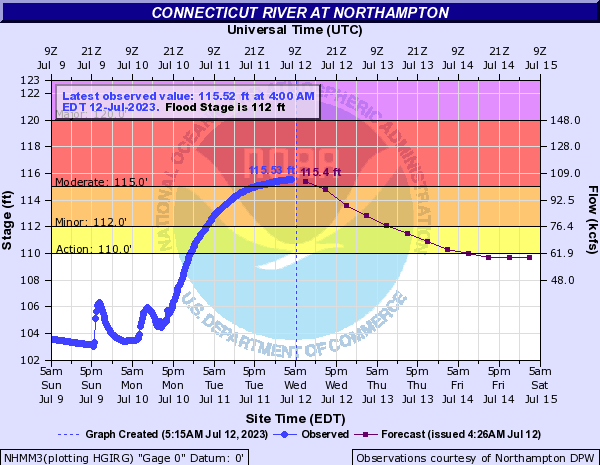
CT River at Hamp crests this AM
Anyways, just some thoughts for the day… as for our weather, the CT River flooding (and others like the Housatonic) will slowly recede over the next couple of days, and no doubt major damage and crop loss has transpired for some, which is terrible, and I will be supporting the farms I frequent, and hopefully you will too, they will need us.
We still have at least a week to go in this humid, and at times wet pattern, with many more chances for showers and thunderstorms, so the flash flooding potential is not yet over, but before we get into a summary below, let’s check a note from our local and delicious sponsor, #TandemBagelCo, with their newest location in the Stop & Shop Plaza on King Street in Northampton, MA.
~~~~~~~~~~~~~~~~~~~
>>> A NOTE FROM OUR SPONSOR <<<
Dave Hayes The Weather Nut is Sponsored by Individual Community Members, Patrons & Tandem Bagel Company... No matter the weather, Tandem Bagel is always there for you at several valley locations to make your mornings brighter! With bagels baked fresh daily (including Gluten-Free options), house-whipped cream cheese, coffee, and tons of lunch options, Tandem is the perfect quick stop for lunch, breakfast, or a coffee and bagel to go. Find them in Easthampton, Northampton, Hadley, Florence, and West Springfield, or use their super-streamlined online ordering tool by visiting their website.
~~~~~~~~~~~~~~~~~~~
SUMMARY:
–Patchy dense fog will burn off this morning
–A mostly sunny day with some afternoon clouds is expected
–Highs will reach the low 80s to low 90s with muggy dewpoints in the 60s to low 70s
–Some afternoon isolated showers, downpours or thunderstorms are possible, with heavy rain being the main issue
–We can’t rule out a strong to even severe thunderstorm with gusty winds being the main issue with stronger wind shear around
–Any showers or storms die down at night, with lows in the low to mid 60s with patchy fog late
–Thursday will be similar with highs in the mid to upper 80s and scattered afternoon showers or storms, but many should stay dry
–The Thursday night to Friday morning period will feature a boundary moving into the WMass region, and we could see a line of overnight showers, downpours and thunderstorms
–I will update on this potential tomorrow for the pooch owners/lovers
–Then we turn once again to the regional disturbances that emanate from the parent upper low pressure system in central Canada that has shedding and spawning so many “child” upper lows and troughs that keep bringing the showers and storms
–It looks like another disturbance will come through on Friday and Friday night, and if vigorous enough could cause some localized flash flooding to renew given saturated soils in place
–Another such system looks to come through Sunday (not to mention the chance for afternoon scattered showers/storms on Saturday)
–Based on the CT River in flood, I am hoping that the heaviest impacts, whatever they might be, come late in the weekend into early next week to give the CT and other streams that are swollen time to release their waters down stream
–Through this entire unsettled period (Friday through Monday) that highs should be mainly in the 75-80º range in the high terrain, and 80-85º in the valleys, with lows in the 60s, and mostly quite humid
–It is by sometime next Tuesday that we may see an actual (although probably temporary) air mass change to drier, seasonable conditions by mid to late week, that’s the hope!
–However, to get there, we may be dealing with strong to severe thunderstorms as a strong cold front could press through the region
–I will keep you updated on all of it as the days get closer, because little changes will no doubt occur and we’ll get clarity in how all of these individual shortwaves will move through our regional flow in the coming days
That’s how it looks now, folks, I hope somehow that your day goes well for you, even though I know for those affected directly by the flooding of the CT River and other recent flash floods that it’s going to take time.
Be well, Dave
