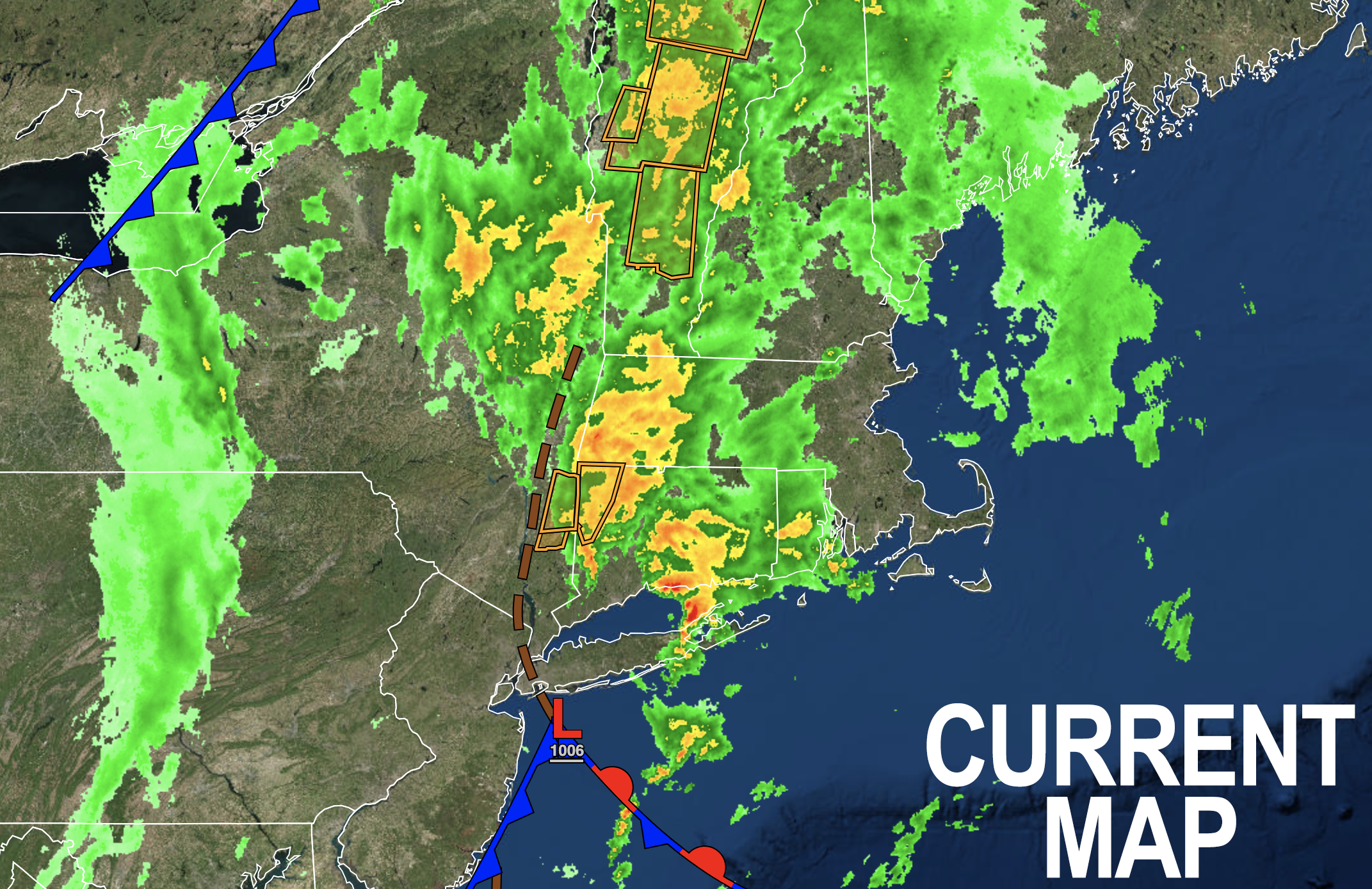
 Good morning everybody, moderate to heavy rainfall continues for much of WMass, northern CT, southwest NH and pushing into SVT with a lull in CMass this early morning period, with the heaviest rain over the western hilltowns into the central and northern Berkshires.
A surface low over the New York Bight will combine with a saturated air mass, a mid/upper low swinging into eastern NY as it becomes closed off in its low/mid levels, and a trough over high terrain areas to ring out moisture and produce scattered areas of flash flooding that could cause road damage, washouts, street/stream flooding, and other problems with the greatest impacts in portions of VT, and potentially in parts of northwest MA, but before we get into a summary below, let’s check a note from our local and delicious sponsor, #TandemBagelCo, with their newest location in the Stop & Shop Plaza on King Street in Northampton, MA.
~~~~~~~~~~~~~~~~~~~
>>> A NOTE FROM OUR SPONSOR <<<
Dave Hayes The Weather Nut is Sponsored by Individual Community Members, Patrons & Tandem Bagel Company... No matter the weather, Tandem Bagel is always there for you at several valley locations to make your mornings brighter! With bagels baked fresh daily (including Gluten-Free options), house-whipped cream cheese, coffee, and tons of lunch options, Tandem is the perfect quick stop for lunch, breakfast, or a coffee and bagel to go. Find them in Easthampton, Northampton, Hadley, Florence, and West Springfield, or use their super-streamlined online ordering tool by visiting their website.
~~~~~~~~~~~~~~~~~~~
SUMMARY
–Flood Advisories are up for the Berkshires this morning, and Flood and Flash Flood Warnings continue in parts of southwest NH, Litchfield County CT and in the northern Berkshires (for the Hoosic River)
–Moderate to heavy rainfall continues in much of the WMass region this morning
–An upper level low will slowly track into eastern NY and become negatively tilted, drawing moisture in off of the Atlantic Ocean
–A weak surface low with a frontal boundary has formed south of Long Island
–These features within the context of a saturated atmosphere and driving flow north and northwest into the high terrain of western New England, mainly west of the I-91 corridor, will help produce rain, heavy at times
–High will reach the low to upper 70s today under overcast skies
–Flash flooding of streets and streams is expected in parts of the region, especially in the central and northern Berkshires, the hilltowns of western Hampshire/Franklin Counties, southwest NH and most notably in Vermont
–Some moderate to heavy damage is possible with road washouts/damage, and flooded streams/streets
–While an additional half inch to 2″+ of rain is expected in the valley points south and east including much of northern CT, an additional 2-5″+ will likely fall west of the I-91 corridor north of the Pike in the aforementioned areas of northwest MA and VT/NH, which is where the greatest flooding issues are expected
–The threat for widespread catastrophic flooding is lessened as of this morning, but we should still see some major problems generally along and north of the Rt. 2 corridor and west of I-91 in far northwest MA and VT
–A dry slot works into northwest CT and southwest MA spreading northeast by sometime this afternoon
–This is when additional showers, downpours and even a few strong thunderstorms could develop and additional rain this afternoon and evening
–Remember to turn around and don’t drown if you encounter flooded road ways
–Lows tonight will drop into the upper 50s to low 60s as showers dissipate into the night
–Tuesday is drier with at least partly sunny skies developing and highs in the upper 70s to mid 80s with a morning shower possible, and lows near 60º
–Wednesday is the pick of the week with highs in the mid 80s to low 90s under mostly sunny skies as humidity is set to build into the late week period
–By Thursday into the weekend it looks like another upper level system will drop inot the Great Lakes and encourage more moist southerly flow, humidity, and periods of showers and thunderstorms
–Some of these t-storms could become strong to severe, so stay tuned for updates
That’s it for now, folks, I will be on the case throughout today and tonight with more posted updates and info as it comes in!
Have a great day!
