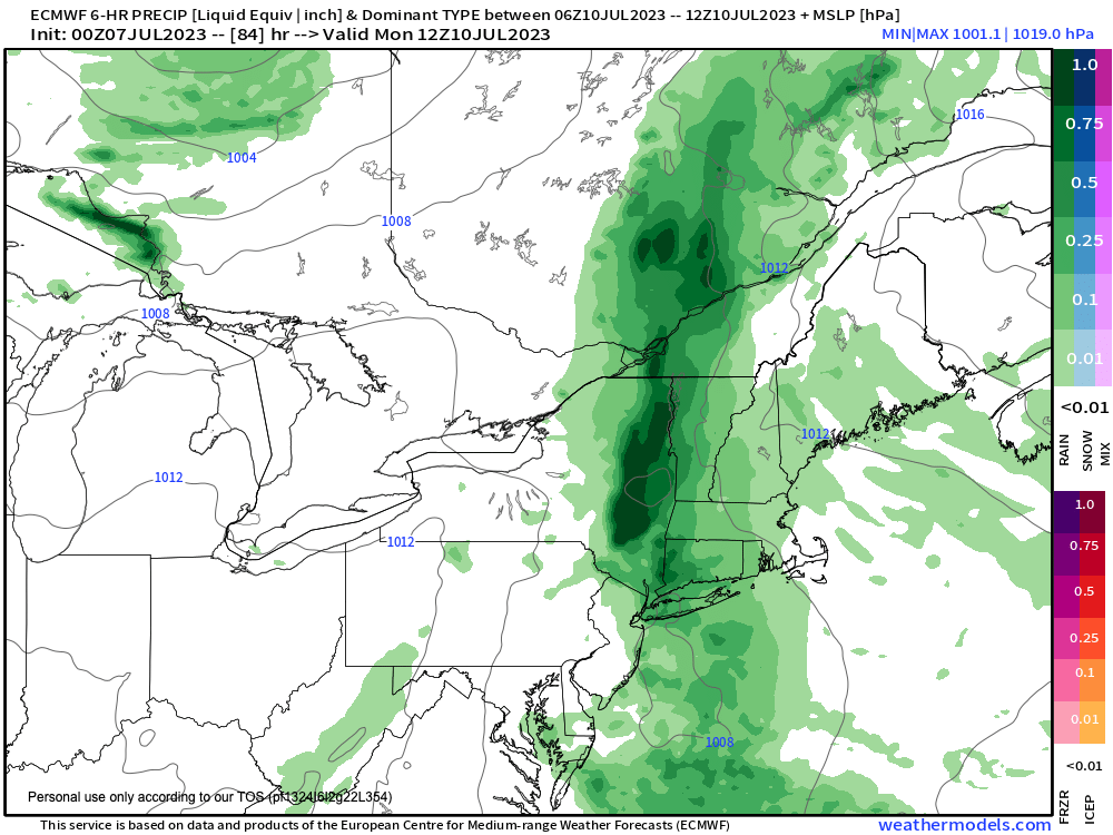
Flooding rains possible Sunday night into Monday
~~~~~~~~~~~~~~~~~~~
>>> A NOTE FROM OUR SPONSOR <<< Dave Hayes The Weather Nut is Sponsored by Individual Community Members, Patrons & Tandem Bagel Company... No matter the weather, Tandem Bagel is always there for you at several valley locations to make your mornings brighter! With bagels baked fresh daily (including Gluten-Free options), house-whipped cream cheese, coffee, and tons of lunch options, Tandem is the perfect quick stop for lunch, breakfast, or a coffee and bagel to go. Find them in Easthampton, Northampton, Hadley, Florence, and West Springfield, or use their super-streamlined online ordering tool by visiting their website.
~~~~~~~~~~~~~~~~~~~
SUMMAH-RY
–We’ve got one more day of drier air aloft that will help keep most showers at bay late this afternoon
–The exception would be far northwest CT, the Berkshires, Taconics, and southwest VT, where some showers, or even a few downpours or a t-storm should develop by the 5-9pm period
–Otherwise, expect another humid and very warm day with highs in the 85-90º range, and heat indices into the low 90s
–After patchy fog burns off by mid morning, skies will become mostly sunny and lows tonight will be in the mid to upper 60s for another sticky night
–For Saturday, some more moisture will push into the region and it will become more humid
–The expectation is for more clouds than sun with highs in the mid to upper 80s, and a quicker arrival/development of showers and a few thunderstorms by mid to late afternoon
–Lows will dip into the mid to upper 60s, and a few showers or a storm is still possible, especially in the first part of the night
–By Sunday, I will be watching a trough eject east out of the Great Lakes region, with a surface low developing near the northern Mid-Atlantic region
–A plume of thicker moisture at all levels will advect northeast into New England, as this low pushes toward the southern New England coastline
–This will likely help produce slow-moving heavier showers and downpours with a few embedded thunderstorms, but severe weather is not expected
–Still, flash flooding is quite possible at this range, as heavy rain production is looking more likely and could last Sunday night into Monday, and perhaps even into Monday night
–This heavy rain threat is the main concern, including street flooding and even stream flooding, so please stay tuned for updates on this developing situation
–Temps will come down on Sunday, under cloudy skies, with highs either side of 80º, and only in the mid to upper 70s on Monday the way it looks now
–By Tuesday, we’ll reach a transition day with at least a chance for lingering showers from this wet system, but hopefully we’ll be getting back into some sunshine in the afternoon
–Once we reach mid-week, we should return to a very warm and humid pattern with partly to mostly sunny skies and afternoon scattered showers and thunderstorms through the end of the week the way it looks now, with highs well into the 80s
Have a great day!
