>>>POST SECTIONS<<<
--DHTWN's Reminder (Food)
--Weekly Nutshell (Overall impact list)
--Sponsor Note (Tandem Bagel Co.)
--NWS Alerts (Advisories, Warnings, Watches)
--Celestial Data (Sun/Moon info)
--Regional Summaries (Local expectations)
--Morning Discussion (Detailed Weather Story)
~~~~~~~~~~~~~~~~~~~~~~
>>> DHTWN REMINDER <<<
If you have food in your fridge, or your pantry, or can get access to it, if you know how to cook or prepare basic foods, and if you can chew it and swallow your food and digest it, you're doing amazingly well in life. Well done. I'm serious. Think about it. Life starts there. Oxygen, Water, Food, Shelter. Family. Friends. Good.
~~~~~~~~~~~~~~~~~~~~~~
>>> DAVE’S WEEKLY WEATHER NUTSHELL <<<
--Patchy fog possible each early morning through Thursday
--Decreasing shower/storm activity today through Thursday compared to yesterday and overnight
--Highs in the 75-80º range, lows in the 60s
--Friday is the pick of the week with partly to mostly sunny skies and lower humidity
--This should carry into Saturday and last as late as Saturday night
--More humid and increasing chance of showers/storms Sunday into early next week but for now, let's check a note from our local and delicious sponsor, #TandemBagelCo, with their newest location in the Stop & Shop Plaza on King Street in Northampton, MA.
~~~~~~~~~~~~~~~~~~~~~~
>>> A NOTE FROM OUR SPONSOR <<<
Dave Hayes The Weather Nut is Sponsored by Individual Community Members, Patrons & Tandem Bagel Company... No matter the weather, Tandem Bagel is always there for you at several valley locations to make your mornings brighter! With bagels baked fresh daily (including Gluten-Free options), house-whipped cream cheese, coffee, and tons of lunch options, Tandem is the perfect quick stop for lunch, breakfast, or a coffee and bagel to go. Find them in Easthampton, Northampton, Hadley, Florence, and West Springfield, or use their super-streamlined online ordering tool by visiting their website.
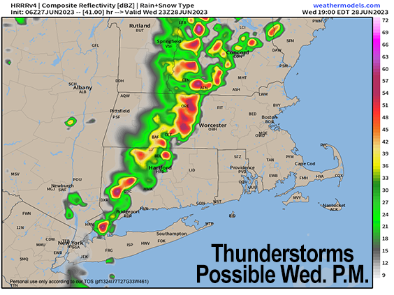
>>> NATIONAL WEATHER SERVICE ALERTS <<< --Flood Watch in southwest NH through tonight >>> YOUR DAILY CELESTIALS <<< STAR: --OUR STAR ROSE AT: 5:16am this morning --OUR STAR WILL SET AT: 8:30pm this evening --TOTAL DAYLIGHT TIME: 15 hours and 14 minutes MOON: --OUR MOON WILL RISE AT: 2:21pm this afternoon --MOON RISE DIRECTION: East --OUR MOON WILL SET AT: 1:32am tomorrow morning --MOON SET DIRECTION: West-Southwest --MOON PHASE: Waxing Gibbous (61.3%) >>> YOUR DAILY TERRESTRIALS <<< ZONE 1 - Northern Region (Southern VT, Southwest NH) --High Temps (Today): Mid to Upper 70s --Low Temps (Tonight): Mid 60s --High Temps (Tomorrow): Mid to Upper 70s --Winds: Light southerly wind through tomorrow --Sky Cover: Mostly cloudy with a few sunny breaks at times, especially Wednesday --Precipitation: Isolated to Scattered showers and t-storms --NWS Alerts / Nut Notes: Flood Watch is up for southwest NH... Patchy dense fog ZONE 2 - Central Region (Western MA, North-Central MA, Northern Litchfield CT) --High Temps (Today): Mid to Upper 70s --Low Temps (Tonight): Mid 60s --High Temps (Tomorrow): Mid 70s to Low 80s --Winds: Light southerly wind through tomorrow --Sky Cover: Mostly cloudy with a few sunny breaks at times, especially Wednesday --Precipitation: Isolated to Scattered showers and t-storms --NWS Alerts / Nut Notes: Patchy dense fog ZONE 3 - Southern Region (South-Central MA, Northern CT) --High Temps (Today): Mid to Upper 70s --Low Temps (Tonight): Mid 60s --High Temps (Tomorrow): Upper 70s to Low 80s --Winds: Light southerly wind through tomorrow --Sky Cover: Mostly cloudy with a few sunny breaks at times, especially Wednesday --Precipitation: Isolated to Scattered showers and t-storms --NWS Alerts / Nut Notes: Patchy dense fog >>> MORNING DISCUSSION <<< Good morning everybody, well that quite the rocking evening and overnight period with torrential rainfall and frequent lightning for some folks, while others not so much. I will be sharing some incredible footage from last night by one of our neighbors later today, as I want to include it in its own post, separate from this morning update. For now, we're in the process of seeing our upper low system to our west "open up" and weaken with time. This means that without any disturbances moving through like we had yesterday, showers and storms should be farther and fewer between. We can expect large lulls in activity today, but isolated to scattered showers and storms will develop into tomorrow with steady highs in the 75-80º range, lows in the 60s, and a humid air mass. Humidity should persist into Thursday when drier air will be starting to reduce our humidity into Friday, which is a day when dewpoints should only make it into the 50s under mostly sunny skies. The next disturbance that brings back the humidity may take until Sunday to get here, or we may re-humidify and get more showers back in here by Saturday evening and night, I will have to update this piece. Hopefully we should get some more sunshine in here by early next week, but a generally unsettled and humid pattern looks to persist into early July. Have a great day! >>> BE KIND <<< “Hello babies. Welcome to Earth. It's hot in the summer and cold in the winter. It's round and wet and crowded. On the outside, babies, you've got a hundred years here. There's only one rule that I know of, babies: Goddamn it, you've got to be kind.” --Kurt Vonnegut
