>>>POST SECTIONS<<<
--DHTWN's Reminder (Shelter)
--Weekly Nutshell (Overall impact list)
--Sponsor Note (Tandem Bagel Co.)
--NWS Alerts (Advisories, Warnings, Watches)
--Celestial Data (Sun/Moon info)
--Regional Summaries (Local expectations)
--Morning Discussion (Detailed Weather Story)
~~~~~~~~~~~~~~~~~~~~~~
>>> DHTWN REMINDER <<<
If you have a roof over your head and a set of walls to enclose you in a structure that protects you from the elements, it's hard to put into words the level of good fortune you possess - be grateful for and thank your shelter for keeping you dry, warm, safe, and protected.
~~~~~~~~~~~~~~~~~~~~~~
>>> DAVE’S WEEKLY WEATHER NUTSHELL <<<
--Patchy dense fog in Hampden County and a few other spots lifts soon
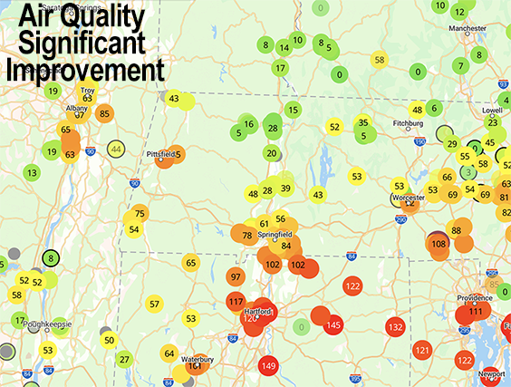
--Air Quality is still compromised in northern CT where AQIs are between 100 and 150, and under 100 elsewhere
--While not high air quality, it is much improved across many areas this morning, and stays that way today
--Scattered afternoon showers, downpours and thunderstorms today
--Some storms may contain hail or gusty winds, and slow-moving downpours are also expected in spots
--Saturday is improved, warmer, highs low/mid 70s, with scattered afternoon showers, less so than today
--Sunday is the pick of the month with sunshine, very warm, highs mid 70s to low 80s, light wind
--Monday clouds up with warm frontal showers by afternoon or evening
--Monday night into Tuesday features more substantial rainfall with a storm and frontal boundary
--Upper level system track west to east mid week with more showers, and all of this should help clear smoke out of here, with more zonal flow (west to east) hopefully by late next week, but for now let's check a note from our local and delicious sponsor, #TandemBagelCo, with their newest location in the Stop & Shop Plaza on King Street in Northampton, MA.
~~~~~~~~~~~~~~~~~~~~~~
>>> A NOTE FROM OUR SPONSOR <<<
Dave Hayes The Weather Nut is Sponsored by Individual Community Members, Patrons & Tandem Bagel Company... No matter the weather, Tandem Bagel is always there for you at several valley locations to make your mornings brighter! With bagels baked fresh daily (including Gluten-Free options), house-whipped cream cheese, coffee, and tons of lunch options, Tandem is the perfect quick stop for lunch, breakfast, or a coffee and bagel to go. Find them in Easthampton, Northampton, Hadley, Florence, and West Springfield, or use their super-streamlined online ordering tool by visiting their website.
>>> NATIONAL WEATHER SERVICE ALERTS <<< --Air Quality Alerts have been hoisted for northern CT thru 1pm >>> YOUR DAILY CELESTIAL <<< STAR: --OUR STAR ROSE AT: 5:14am this morning --OUR STAR WILL SET AT: 8:25pm this evening --TOTAL DAYLIGHT TIME: 15 hours and 11 minutes --PEAK LIGHT IS CRESTING NEXT TWO WEEKS!!! MOON: --OUR MOON WILL SET AT: 11:10am this morning --OUR MOON WILL RISE AT: 1:15am tomorrow morning --MOON SET DIRECTION: West-Southwest --MOON RISE DIRECTION: East-Southeast --MOON PHASE: Waning Gibbous (65.4%) >>> MORNING DISCUSSION <<< Good morning folks, our air quality is much improved today compared to the recent three days, and I believe for now that the worst is behind us. Northern CT is still problematic, and that is why Air Quality Alerts are still up for that area through 1pm today. It's not like our air is pristine and fresh in WMass, SVT or SWNH, but it's way better, so we'll take it. For today, highs will only climb into the 60s after some patchy dense fog burns off, notably in the Berkshires and Hampden County. Are you seeing fog this morning? Any partial sun or sunny breaks will fill in as clouds increase thanks to very cold temps aloft inducing rising air and cloud development as the day wears on. Further convection will result in scattered showers, downpours and thunderstorms forming with strong mid level lapse rates setting up and causing faster rising air. Some storms this later afternoon and evening could drop some small hail or produce strong gusty winds in stronger cells. Showers and storms wind down tonight with lows in the mid to upper 40s. For Saturday, improvement begins as our upper low begins to eject east, but a few isolated showers are expected by afternoon with highs in the upper 60s to mid 70s, and lows near 50º. On Sunday, gorgeousness abounds! We'll at least have partly sunny skies with much warmer temps, with highs cresting into the mid 70s to low 80s with a light west wind. By Monday, though, we'll be watching a warm front tracking toward the region as a new upper low forms over the Great Lakes and wraps a surface low around its base, destined to track northwest of us. This will push showers into the region by later afternoon or evening, and then another surface low may develop toward the NYC metro and track northeast bringing more widespread rainfall Monday night and Tuesday along with an incoming cold front to help enhance rainfall. Monday and Tuesday looks warm, with highs in the 70s, but quite unsettled at this point in time. After the storm moves through Tuesday, our upper low still have to work through the region Wednesday and Thursday with more periods of scattered showers at times and high temps either side of 70º. After that we may see a more zonal flow set up across the northern part of the country, which would fully sweep any remnants smoke or plumes away from our region. Have a great day! >>> BE KIND <<< “Hello babies. Welcome to Earth. It's hot in the summer and cold in the winter. It's round and wet and crowded. On the outside, babies, you've got a hundred years here. There's only one rule that I know of, babies: Goddamn it, you've got to be kind.” --Kurt Vonnegut
