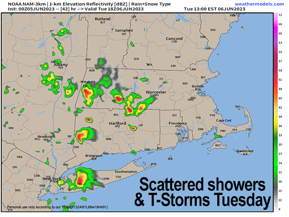
Scattered Tues showers
>>> NATIONAL WEATHER SERVICE ALERTS <<< --None >>> YOUR DAILY CELESTIAL <<< STAR: --OUR STAR ROSE AT: 5:15am this morning --OUR STAR WILL SET AT: 8:22pm this evening --TOTAL DAYLIGHT TIME: 15 hours and 7 minutes --PEAK LIGHT IS CRESTING NEXT TWO WEEKS!!! MOON: --OUR MOON WILL RISE AT: 10:40pm tonight --OUR MOON WILL SET AT: 7:15am tomorrow morning --MOON RISE DIRECTION: Southeast --MOON SET DIRECTION: Southwest --MOON PHASE: Waning Gibbous (97.6%) >>> YOUR DAILY TERRESTRIAL <<< ZONE 1 - Northern Region (Southern VT, Southwest NH) --High Temps (Today): Mid 60s to Low 70s --Low Temps (Tonight): Mid to Upper 40s --High Temps (Tomorrow): Mid 60s to Low 70s --Winds: Light north wind today could gust up to 20mph, then light northwest overnight into Tues. --Sky Cover: Mostly cloudy early, then partly sunny later... mostly cloudy tonight and tomorrow --Precipitation: A few showers possible east of the CT River in SWNH, otherwise drying into tonight, then scattered showers and thunderstorms by tomorrow afternoon --NWS Alerts / Nut Notes: None ZONE 2 - Central Region (Western MA, North-Central MA, Northern Litchfield CT) --High Temps (Today): Mid 60s to Low 70s --Low Temps (Tonight): Upper 40s to Low 50s --High Temps (Tomorrow): Low to Mid 70s --Winds: Light north wind today could gust up to 20mph, then light northwest overnight into Tues. --Sky Cover: Mostly cloudy early, then partly sunny later... mostly cloudy tonight and tomorrow --Precipitation: A few showers possible east of the CT River in SWNH, otherwise drying into tonight, then scattered showers and thunderstorms by tomorrow afternoon --NWS Alerts / Nut Notes: None ZONE 3 - Southern Region (South-Central MA, Northern CT) --High Temps (Today): Mid 60s to Low 70s --Low Temps (Tonight): Upper 40s to Low 50s --High Temps (Tomorrow): Low to Mid 70s --Winds: Light north wind today could gust up to 20mph, then light northwest overnight into Tues. --Sky Cover: Mostly cloudy early, then partly sunny later... mostly cloudy tonight and tomorrow --Precipitation: A few showers possible east of the CT River in SWNH, otherwise drying into tonight, then scattered showers and thunderstorms by tomorrow afternoon --NWS Alerts / Nut Notes: None >>> MORNING DISCUSSION <<< Good morning folks, we're starting off mostly cloudy as a thick moisture plume is tracking south-southwest through the region this morning thanks to our upper low that is centered southeast of Nantucket this morning, and slowly pulling away to the east. This is causing a wave of showers to track through CMass and northeast CT this morning, and a few easternmost areas of WMass may get nicked by a few rain drops or a shower before this feature pulls south and then dissipates as the upper low tracks away from the coastline. A cloudier (and for some, showery or spritzy) morning should give way to partial sunshine and some drying by afternoon with highs in the upper 60s to low 70s along and west of the CT River in VT/NH, MA and CT (provided we get this expected partial sun) with mid to upper 60s east, and upper 50s in far eastern MA. A light north wind may gust up to 20mph at times, especially in CMass. For tonight, clouds will build back into the region with lows in the 40s to near 50º, but should be mostly dry. Tuesday looks a bit warmer with highs in upper 60s to mid 70s with clouds building as a shortwave tracks southeast into New England with another cold front, bringing scattered showers and thunderstorms by Tuesday afternoon (see attached chart). While severe weather is not expected, some small hail may fall from any storms with cool air aloft. Showers will wind down Tuesday night with lows in the 40s. Thereafter, our second upper low in this new cooler/cloudier pattern will drop into New England and wrap waves of moisture and clouds around its center, providing us with the chance of scattered showers each afternoon Wednesday through Friday with some thunder rumbles possible and highs in the 60s, and lows in the 40s. By the weekend, this upper low should lift out of the region, and bestow (hopefully) a nicer, warmer, and at times, sunnier weekend, which would be great timing. Highs could rise into the low to mid 70s the way it looks now, but don't get your summery hopes up yet, because there are signs that ANOTHER upper low may drop out of Canada for early next week, which would mean another cool down and more showers. If you want summer, folks, you want flow from the southwest and south, or at least the west, and not from the north, northwest and northeast, which is the direction from which our weather is currently sourced. On a bright note, we are peaking our daylight over the next couple of weeks as the evenings lengthen with sunsets eventually heading for 8:30pm - almost there, so enjoy that! I hope you have a great day and that things go your way! >>> BE KIND <<< “Hello babies. Welcome to Earth. It's hot in the summer and cold in the winter. It's round and wet and crowded. On the outside, babies, you've got a hundred years here. There's only one rule that I know of, babies: Goddamn it, you've got to be kind.” --Kurt Vonnegut
