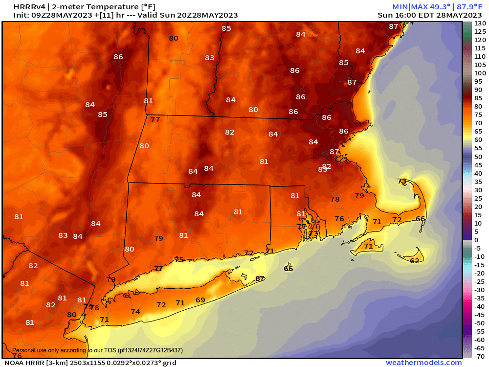
Good morning everybody, the full report is below but after an extremely busy almost 9 months, I need to rest for a few days while we have stable and calm weather expected, so I will not be reporting Monday through Wednesday of this week, but will be back early Thursday morning as our heat peaks followed by a change in air mass expected for this coming weekend with some showers and thunderstorms possible, and cooler temps.
The period from today through Wednesday looks highly stable, and very warm to almost hot today as well as Wednesday with a cooler period Monday and Tuesday behind a back door cold front that should bring some northeasterly breezes tomorrow , but before we jump into the details below, let’s check a note from our weekend sponsor, #RedFireFarm located in Granby, MA.
~~~~~~~~~~~~~~~~~~~~~~
A NOTE FROM OUR WEEKEND SPONSOR:
Dave Hayes The Weather Nut is Sponsored by Individual Community Members, Patrons & Red Fire Farm. The Red Fire Farm store is open daily at 7 Carver Street in Granby, MA, and if you are looking for delicious organic produce, join their Summer CSA farm share. Vibrant greens, luscious heirloom tomatoes, sweet carrots and lots more to enjoy. Shares get free Pick Your Own, kicking off with strawberries in June. Add pastured eggs, local fruit & cheeses, mushrooms, pantry items, bouquets of organic flowers, and more. Weekly pickups at the Granby farm, Montague, Amherst, Forest Park/Springfield, Northampton, & Worcester (plus home delivery available), so click here today and snag your Summer Share!
~~~~~~~~~~~~~~~~~~~~~~~~~~~~~~~~
WEATHER REPORT
A large eastern U.S. Rex Block (high pressure north coupled with low pressure south) will remain in place through late this coming week, and as such, stable and fair weather will continue through the Thursday timeframe at least.
Temps will vary a bit due to factors I’ll quickly run through below, but essentially we’ll enjoy sunny warm days and clear cooler nights with not a drop of rain expected, nor a crystal of frost.
For today, southwest flow will develop, and it could get breezy this afternoon with very warm highs reaching the 85-90º range with low 80s up in southern VT under sunny skies. There may be some light haze high up due to Canadian wildfires.
For tonight, lows will dip to the upper 40s to low 50s with clear skies and patchy fog late in a few spots
On Memorial Day, we’ll cool down as a back door cold front is sent southwestward through our region due to a low pressure system passing southeast into Atlantic Canada, far to our northeast.
This should cause northeast wind to gust up to 20mph tomorrow morning into afternoon. There will be no showers with this frontal passage as it’s far too dry, and highs will reach the mid to upper 70s as a result on Monday and on Tuesday with lows in the 40s with sunny skies during the day and clear skies at night.
By Wednesday, we’ll be warming back up in the low to mid 80s with sunshine, and lows will drop to the 50s.
On Thursday and Friday our heat will peak for this cycle, with high temps expected to rise into the mid 80s to low 90s both days with sunshine on Thursday, and then a mixed sky on Friday with the potential for scattered showers and thunderstorms as a cold front approaches the region.
By the weekend, a cold front will likely be through the region, and highs will sit back down into the 70s, likely with continued fair weather, but as I said in the headline, I am taking the next 3 days to myself so I can get some rest, and I will update you in full no later than Thursday morning.
Thanks very much for your readership and support, and I hope you have a great rest of your holiday weekend!
BE KIND
“Hello babies. Welcome to Earth. It’s hot in the summer and cold in the winter. It’s round and wet and crowded. On the outside, babies, you’ve got a hundred years here. There’s only one rule that I know of, babies: Goddamn it, you’ve got to be kind.”
–Kurt Vonnegut
