
POST SECTIONS (Scroll Below For Yours)
–DHTWN’s Reminder (Keep your Life Force)
–Weekly Nutshell (Quick impact list)
–Sponsor Note (Tandem Bagel Co.)
–NWS Alerts (Advisories, Warnings, Watches)
–Celestial Data (Sun/Moon info)
–Regional Summaries (Quick in/out details)
–Morning Discussion (More Details)
~~~~~~~~~~~~~~~~~~~~~~
DHTWN REMINDER:
There’s a lot of to be distraught about these days, but life goes on, keeps moving, flowing, and willing itself onward. We’re a manifestation and part of that life force, but it goes way beyond us and we’re lucky to be a part of it, even if things aren’t going well. Remember, there’s always a chance things might improve. If you’re struggling, I hope things go better for you today, and I say stay open to the chance that they will – the mind craves certainty, so let’s try to stay open.
~~~~~~~~~~~~~~~~~~~~~~
DAVE’S WEEKLY WEATHER NUTSHELL
–A mix of sunshine, high clouds and Canadian wildfire smoke moves over head today
–Quite warm with highs in the 70s to low 80s, with gusty southwesterlies up to 20-35mph
–Our ground has been dry for weeks, and with very dry air and gusty wind, fires can spread rapidly today, so don’t toss your butts, and watch any open fires (burns, cookouts, etc)
–This is why Red Flag Warnings are up for the region in MA and CT today, with Fire Weather Watches for tomorrow
–Cold front brings clouds tonight, and a few showers
–Temps will be colder overnight, into the upper 30s to low 40s
–A fairly cool and sunny day is up tomorrow with highs mostly in the 50s, with a few low 60s in the southern valley into the Hartford metro
–Winds continue to gust up to 25mph but should slacken at night
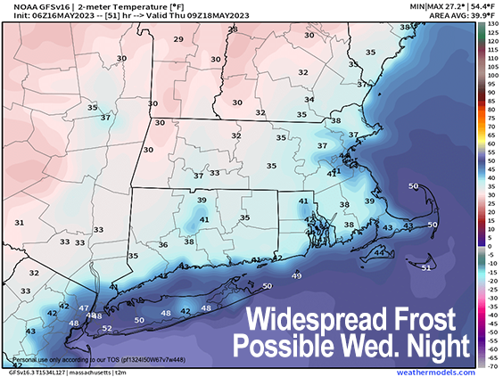
–With clear skies, very dry air, and lighter wind, temps should plummet in northwest flow with lows in the mid 20s to mid 30s!
–This could produce a widespread frost, or even hard freeze in some areas, so plant protection operations will likely need to be undertaken by farms and gardeners
–Thursday and Friday are milder in the 60s to low 70s with sunny skies, some gusty wind Thursday
–The weekend still looks unsettled with a frontal boundary and storm converging over our region, but timing is still uncertain
–At this point, Saturday afternoon overnight into early Sunday morning looks rainy, and I will update as we get closer, but before we continue below let’s check a note from our local and delicious sponsor, #TandemBagelCo, with their newest location in the Stop & Shop Plaza on King Street in Northampton, MA.
~~~~~~~~~~~~~~~~~~~~~~
A NOTE FROM OUR SPONSOR:
Dave Hayes The Weather Nut is Sponsored by Individual Community Members, Patrons & Tandem Bagel Company… No matter the weather, Tandem Bagel is always there for you at several valley locations to make your mornings brighter! With bagels baked fresh daily (including Gluten-Free options), house-whipped cream cheese, coffee, and tons of lunch options, Tandem is the perfect quick stop for lunch, breakfast, or a coffee and bagel to go. Find them in Easthampton, Northampton, Hadley, Florence, and West Springfield, or use their super-streamlined online ordering tool by visiting their website.
~~~~~~~~~~~~~~~~~~~~~~~~~~~~~~~~
***DHTWN DAILY WEATHER REPORT***
~~~~~~~~~~~~~~~~~~~~~~~~~~~~~~~~
NATIONAL WEATHER SERVICE ALERTS
–Red Flag Warnings are up for MA and CT for today, and Fire Weather Watches are up for all of MA and CT for Wednesday… enhanced risk of fire spread exists today and tomorrow for SVT and SWNH
DAILY CELESTIAL (STAR):
–OUR STAR ROSE AT: 5:28am this morning
–OUR STAR WILL SET AT: 8:05pm this evening
–TOTAL DAYLIGHT TIME: 14 hours and 37 minutes
NIGHTLY CELESTIAL (MOON):
–OUR MOON WILL SET AT: 4:58pm this afternoon
–OUR MOON WILL RISE AT: 4:18am tomorrow morning
–MOON SET DIRECTION: West
–MOON RISE DIRECTION: East-Northeast
–MOON PHASE: Waning Crescent (11.6%)
~~~~~~~~~~~~~~~~~~~~~~~~~~~~~~~~
DAILY TERRESTRIAL
ZONE 1 – Northern Region
(Southern VT, Southwest NH)
–High Temps (Today): Low to Upper 70s
–Low Temps (Tonight): Mid 30s to Low 40s
–High Temps (Tomorrow): Low to Upper 50s
–Winds: Southwesterly gusts 20-35mph today, lighter northerly tonight, northwesterly 15-25mph tomorrow
–Sky Cover: Partial sun with high clouds and Canadian wildfire smoke creating haze at times
–Precipitation: Dry today, a few showers of insignificance tonight, dry tomorrow
–NWS Alerts / Nut Notes: Enhanced Risk for Fire Spread today, despite there not being Red Flag Warnings hoisted for this zone.
ZONE 2 – Central Region
(Western MA, North-Central MA, Northern Litchfield CT)
–High Temps (Today): Mid 70s to Low 80s
–Low Temps (Tonight): Upper 30s to Mid 40s
–High Temps (Tomorrow): Mid 50s to Low 60s
–Winds: Southwesterly gusts 20-35mph today, lighter northerly tonight, northwesterly 15-25mph tomorrow
–Sky Cover: Partial sun with high clouds and Canadian wildfire smoke creating haze at times
–Precipitation: Dry today, a few showers of insignificance tonight, dry tomorrow
–NWS Alerts / Nut Notes: Red Flag Warnings are UP for the entire region, ground/brush fires can spread rapidly today and tomorrow due to gusty winds, antecedent dry ground, and exceptionally dry air…. Fire Weather Watches are up for tomorrow as well
ZONE 3 – Southern Region
(South-Central MA, Northern CT)
–High Temps (Today): Upper 70s to Low 80s
–Low Temps (Tonight): Mid to Upper 40s
–High Temps (Tomorrow): Upper 50s to Low 60s
–Winds: Southwesterly gusts 20-35mph today, lighter northerly tonight, northwesterly 15-25mph tomorrow
–Sky Cover: Partial sun with high clouds and Canadian wildfire smoke creating haze at times
–Precipitation: Dry today, a few showers of insignificance tonight, dry tomorrow
–NWS Alerts / Nut Notes: Red Flag Warnings are UP for the entire region, ground/brush fires can spread rapidly today and tomorrow due to gusty winds, antecedent dry ground, and exceptionally dry air…. Fire Weather Watches are up for tomorrow as well
~~~~~~~~~~~~~~~~~~~~~~~~~~~~~~~~
MORNING DISCUSSION
Good morning folks, the sections above handle most of what we can expect weather-wise over the coming 5-7 days.
The bottom line is that it has been exceptionally dry for a couple of weeks now, and with exceptionally dry air advecting into the region over the next couple of days along with increasing westerly winds, today and tomorrow will be especially prone to brush fires spreading more rapidly, so please consider others regarding outdoor use of fire today and tomorrow.
In addition, we’ve got some wildfire smoke haze in the skies today which will be swept out of here by the cold front, I believe.
The potential for frost/freeze has been well-advertised on this page and my website for days now pertaining to tomorrow night.
This trend is continuing, and if anything temps have trended downward slightly, so we could see a number of folks in the mid to upper 20s by early Thursday morning, but it will depend on the wind.
Hopefully, the wind unexpectedly holds up and continues late Wednesday night, that would keep the air mixed and keep the coldest temps from materializing, though many could still see frost in that scenario.
It’s the hard freeze we’re hoping to avoid.
Lastly, the best chance for rain exists for Saturday night, so let’s hope for that, as it looks DRY next week, so our local Earth sector could use a good drink.
I hope you have a great day and that things go your way!
BE KIND
“Hello babies. Welcome to Earth. It’s hot in the summer and cold in the winter. It’s round and wet and crowded. On the outside, babies, you’ve got a hundred years here. There’s only one rule that I know of, babies: Goddamn it, you’ve got to be kind.”
–Kurt Vonnegut