
POST SECTIONS (Scroll Below For Yours)
–DHTWN’s Reminder (Keep your Life Force)
–Weekly Nutshell (Quick impact list)
–Sponsor Note (Tandem Bagel Co.)
–NWS Alerts (Advisories, Warnings, Watches)
–Celestial Data (Sun/Moon info)
–Regional Summaries (Quick in/out details)
–Morning Discussion (More Details)
~~~~~~~~~~~~~~~~~~~~~~
DHTWN REMINDER:
There’s a lot of to be distraught about these days, but life goes on, keeps moving, flowing, and willing itself onward. We’re a manifestation and part of that life force, but it goes way beyond us and we’re lucky to be a part of it, even if things aren’t going well. Remember, there’s always a chance things might improve. If you’re struggling, I hope things go better for you today, and I say stay open to the chance that they will – the mind craves certainty, so let’s try to stay open.
~~~~~~~~~~~~~~~~~~~~~~
DAVE’S WEEKLY WEATHER NUTSHELL
–Fair weather continues to dominate our region with sunshine through the week
–Some high clouds at times today are expected, with warmer-than-Sunday temps mostly in the 70s
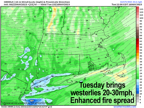
–Westerlies will gust 15-25mph north of the Pike today, so some enhanced fire spread northern MA, SVT, SWNH
–Milder tonight than this morning, which produced some frost and 30s temps
–Southwest to west gusts 20-30mph or so tomorrow with sun and quite warm in the 70s to low 80s with fire spread concerns Tuesday, Wednesday and even Thursday
–A few rain drops possible Tuesday night as a cold front passes through and sees much of its moisture evaporate on the way through
–Cool and windy Wednesday, highs 50s and 60s, fire spread risk continues
–If wind settles down enough Wednesday night a *hard freeze* is possible, and at this point, we’ll be lucky if we only get a patchy frost, as frost looks pretty likely
–Late week looks like fair weather, with breezy conditions Thursday and sunny through Friday, with even a decent day possible Saturday
–Then we look to our first substantial rainfall in a while now for Sunday, with continued lovely Spring weather moving in after it for next week, but before we continue below let’s check a note from our local and delicious sponsor, #TandemBagelCo, with their newest location in the Stop & Shop Plaza on King Street in Northampton, MA.
~~~~~~~~~~~~~~~~~~~~~~
A NOTE FROM OUR SPONSOR:
Dave Hayes The Weather Nut is Sponsored by Individual Community Members, Patrons & Tandem Bagel Company… No matter the weather, Tandem Bagel is always there for you at several valley locations to make your mornings brighter! With bagels baked fresh daily (including Gluten-Free options), house-whipped cream cheese, coffee, and tons of lunch options, Tandem is the perfect quick stop for lunch, breakfast, or a coffee and bagel to go. Find them in Easthampton, Northampton, Hadley, Florence, and West Springfield, or use their super-streamlined online ordering tool by visiting their website.
~~~~~~~~~~~~~~~~~~~~~~~~~~~~~~~~
***DHTWN DAILY WEATHER REPORT***
~~~~~~~~~~~~~~~~~~~~~~~~~~~~~~~~
NATIONAL WEATHER SERVICE ALERTS
–Fire Weather Watches are up for all of MA and CT for Tuesday and Wednesday… enhanced risk of fire spread today for northern MA, SVT and SWNH
DAILY CELESTIAL (STAR):
–OUR STAR ROSE AT: 5:29am this morning
–OUR STAR WILL SET AT: 8:04pm this evening
–TOTAL DAYLIGHT TIME: 14 hours and 35 minutes
NIGHTLY CELESTIAL (MOON):
–OUR MOON WILL SET AT: 3:47pm this afternoon
–OUR MOON WILL RISE AT: 3:56am tomorrow morning
–MOON SET DIRECTION: West
–MOON RISE DIRECTION: East
–MOON PHASE: Waning Crescent (19.7%)
~~~~~~~~~~~~~~~~~~~~~~~~~~~~~~~~
DAILY TERRESTRIAL
ZONE 1 – Northern Region
(Southern VT, Southwest NH)
–High Temps (Today): Upper 60s to Mid 70s
–Low Temps (Tonight): Upper 40s to Low 50s
–High Temps (Tomorrow): Low to Upper 70s
–Winds: Westerly gusts 15-25mph today and tonight, and up to 30mph or so tomorrow
–Sky Cover: Sunny today with some high clouds, partly cloudy tonight, mostly sunny tomorrow
–Precipitation: A few showers tomorrow night are possible, otherwise dry until then
–NWS Alerts / Nut Notes: Elevated risk for fire spread today and tomorrow due to breezy conditions, dry air, and dry ground, so mind your #BurnsButtsAndBBQs
ZONE 2 – Central Region
(Western MA, North-Central MA, Northern Litchfield CT)
–High Temps (Today): Low to Upper 70s (upper range in the valley)
–Low Temps (Tonight): Mid 40s to Low 50s
–High Temps (Tomorrow): Mid 70s to Low 80s
–Winds: Westerly gusts 10-20mph today and tonight, and up to 25mph or so tomorrow
–Sky Cover: Sunny today with some high clouds, partly cloudy tonight, mostly sunny tomorrow
–Precipitation: A few showers tomorrow night are possible, otherwise dry until then
–NWS Alerts / Nut Notes: Fire Weather Watches have been hoisted by the NWS for Tuesday and Wednesday due to breezy conditions, dry air and dry ground, so mind your #BurnsButtsAndBBQs
ZONE 3 – Southern Region
(South-Central MA, Northern CT)
–High Temps (Today): Low to Mid 70s
–Low Temps (Tonight): Upper 40s to Low 50s
–High Temps (Tomorrow): Upper 70s to Low 80s
–Winds: Westerly gusts 10-20mph today and tonight, and up to 25mph or so tomorrow
–Sky Cover: Sunny today with some high clouds, partly cloudy tonight, mostly sunny tomorrow
–Precipitation: A few showers tomorrow night are possible, otherwise dry until then
–NWS Alerts / Nut Notes: Fire Weather Watches have been hoisted by the NWS for Tuesday and Wednesday due to breezy conditions, dry air and dry ground, so mind your #BurnsButtsAndBBQs
~~~~~~~~~~~~~~~~~~~~~~~~~~~~~~~~
MORNING DISCUSSION
Good morning folks, the overall story is that we’re having a rocking Spring at this point!
We are still dealing with some cold mornings, but we’ve had lots of fair weather and will continue to see plenty of sunshine through the next 6 days in a row!
Holy crap, that’s a lot of exclamation points so early in the morning, Dave!!!! Stop it already!!!!!!
Whoa, sorry about that folks, I got carried way (resists urge to place an exclamation point at the end of the preceding sentence).
We’ve got giant high pressure centered over the Dakotas which will sag south or southeast slowly, and bring plenty of sunshine today and tomorrow with warming temps and increasingly breezy conditions, especially for tomorrow.
Sunny highs (with some high clouds) today in the upper 60s to 70s lead to partly cloudy lows in the upper 40s to low 50s tonight under partly cloudy skies. It’ll be gustier well north of the Pike compared to along and south of it today.
For Tuesday, we’re even warmer with highs in the 70s to low 80s as southwesterlies kick up to 20-35mph at times under sunny skies.
Clouds build Tuesday night with an incoming cold front, and a few showers possible, but they look like no big whoop material if you ask me.
However, the trough that swipes the region Wednesday behind that cold front will cool us right down and keep the winds up for Wednesday, this time out of the northwest 20-35mph with highs in the 50s to low 60s – a bit chilly.
The real chill comes Wednesday night, when widespread frost is expected at the moment, with a potential for freezes if the wind dies down at night – lows could be in the 20s for some!
Thursday looks breezy as well, and sunny, with highs in the 60s, which extends into Friday.
Saturday is a bit uncertain, as is much of the weekend but we could squeeze out a partly sunny day Saturday with warmer temps into the 70s before a potential rainstorm develops late Saturday night or on Sunday, with fair weather likely to kick off next week, so please stay tuned for details and any forecast changes.
I hope you have a great day and that things go your way!
BE KIND
“Hello babies. Welcome to Earth. It’s hot in the summer and cold in the winter. It’s round and wet and crowded. On the outside, babies, you’ve got a hundred years here. There’s only one rule that I know of, babies: Goddamn it, you’ve got to be kind.”
–Kurt Vonnegut