POST SECTIONS (Scroll Below For Yours)
–DHTWN’s Reminder (Keep your Life Force)
–Weekly Nutshell (Quick impact list)
–Sponsor Note (Tandem Bagel Co.)
–NWS Alerts (Advisories, Warnings, Watches)
–Celestial Data (Sun/Moon info)
–Regional Summaries (Quick in/out details)
–Morning Discussion (More Details)
~~~~~~~~~~~~~~~~~~~~~~
DHTWN REMINDER:
There’s a lot of to be distraught about these days, but life goes on, keeps moving, flowing, and willing itself onward. We’re a manifestation and part of that life force, but it goes way beyond us, and we’re lucky to be a part of it. Even if things aren’t going well, there’s always a chance things might improve. If you’re struggling, I hope things go better for you today, and stay open to the chance that they will – they just might.
~~~~~~~~~~~~~~~~~~~~~~
DAVE’S WEEKLY WEATHER NUTSHELL
–Frosty patches this morning give way to quick warming through the 60s and into the low 70s today
–Haze from Canadian wildfires likely visits our skies again with filtered sunshine
–Light west to southwest wind today, tonight and tomorrow
–Lows mainly in the 40s for the foreseeable future, maybe low 50s Friday night
–Chance for isolated shower Thursday or Friday, otherwise mostly sunny and warming well into the 70s both days, possibly into the low 80s Friday
–Saturday looks partly sunny with a wave passing south of us, with cooler temps Sunday into Monday, but before we continue below let’s check a note from our local and delicious sponsor, #TandemBagelCo, with their newest location in the Stop & Shop Plaza on King Street in Northampton, MA.
~~~~~~~~~~~~~~~~~~~~~~
A NOTE FROM OUR SPONSOR:
Dave Hayes The Weather Nut is Sponsored by Individual Community Members, Patrons & Tandem Bagel Company… No matter the weather, Tandem Bagel is always there for you at several valley locations to make your mornings brighter! With bagels baked fresh daily (including Gluten-Free options), house-whipped cream cheese, coffee, and tons of lunch options, Tandem is the perfect quick stop for lunch, breakfast, or a coffee and bagel to go. Find them in Easthampton, Northampton, Hadley, Florence, and West Springfield, or use their super-streamlined online ordering tool by visiting their website.
~~~~~~~~~~~~~~~~~~~~~~~~~~~~~~~~
***DHTWN DAILY WEATHER REPORT***
~~~~~~~~~~~~~~~~~~~~~~~~~~~~~~~~
NATIONAL WEATHER SERVICE ALERTS
–None
DAILY CELESTIAL (STAR):
–OUR STAR ROSE AT: 5:35am this morning
–OUR STAR WILL SET AT: 7:58pm this evening
–TOTAL DAYLIGHT TIME: 14 hours and 23 minutes
NIGHTLY CELESTIAL (MOON):
–OUR MOON WILL SET AT: 9:30am this morning
–OUR MOON WILL RISE AT: 1:37am tomorrow morning
–MOON SET DIRECTION: Southwest
–MOON RISE DIRECTION: Southeast
–MOON PHASE: Waning Gibbous (73.8%)
~~~~~~~~~~~~~~~~~~~~~~~~~~~~~~~~
DAILY TERRESTRIAL
ZONE 1 – Northern Region
(Southern VT, Southwest NH)
–High Temps (Today): Upper 60s to Low 70s
–Low Temps (Tonight): Low to Mid 40s
–High Temps (Tomorrow): Mid to Upper 70s
–Winds: Light and variable out of the west and southwest through tomorrow
–Sky Cover: Mostly sunny today, some haze from Canadian wildfire smoke, clear tonight, mostly sunny tomorrow
–Precipitation: None today or tonight, isolated shower possible tomorrow
–NWS Alerts / Nut Notes: None
ZONE 2 – Central Region
(Western MA, North-Central MA, Northern Litchfield CT)
–High Temps (Today): Upper 60s to Mid 70s
–Low Temps (Tonight): Low to Upper 40s
–High Temps (Tomorrow): Mid to Upper 70s
–Winds: Light and variable out of the west and southwest through tomorrow
–Sky Cover: Mostly sunny today, some haze from Canadian wildfire smoke, clear tonight, mostly sunny tomorrow
–Precipitation: None today or tonight, isolated shower possible tomorrow
–NWS Alerts / Nut Notes: None
ZONE 3 – Southern Region
(South-Central MA, Northern CT)
–High Temps (Today): Upper 60s to Low 70s
–Low Temps (Tonight): Mid to Upper 40s
–High Temps (Tomorrow): Upper 70s to Low 80s
–Winds: Light and variable out of the west and southwest through tomorrow
–Sky Cover: Mostly sunny today, some haze from Canadian wildfire smoke, clear tonight, mostly sunny tomorrow
–Precipitation: None today or tonight, isolated shower possible tomorrow
–NWS Alerts / Nut Notes: None
~~~~~~~~~~~~~~~~~~~~~~~~~~~~~~~~
MORNING DISCUSSION
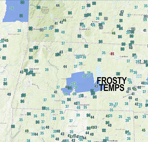
Good morning everybody, anyone get frost this morning? I saw some upper 20s in southwest NH, and lots of low to mid 30s. Where relative humidities were in the mid 80s to upper 90s in terms of percentages, I’m sure frost formed, so let me know if you got some, hope you got any tender morsels protected.
We will rebound well today, rising through the 60s and into the low 70s under mostly sunny but hazy skies at times as smoke from Canadian wildfires makes its undulating crazy path through the north of Canada down through Hudson Bay and into New England.
High pressure is pressing in from the west and will get south of us tomorrow, which will continue the warming trend through the end of the week into Saturday.
We could see a spot shower between Thursday and Saturday, and possibly an isolated thunderstorm Friday, but we will be mostly dry through the period and some of us will crest 80º by Friday (see above zones and nutshell sections for temps etc).
A wave moves through Saturday and bring a frontal boundary through as well, which should cool us down into the 65-70º range for Sunday and Monday, with warmer 70s expected by the middle of next week when our next real rain chance exists.
Otherwise, it’s mostly dry, mostly sunny, mostly calm wind, and mostly pollen-y.
I hope you have a great day and that things go your way!
BE KIND
“Hello babies. Welcome to Earth. It’s hot in the summer and cold in the winter. It’s round and wet and crowded. On the outside, babies, you’ve got a hundred years here. There’s only one rule that I know of, babies: Goddamn it, you’ve got to be kind.”
–Kurt Vonnegut
