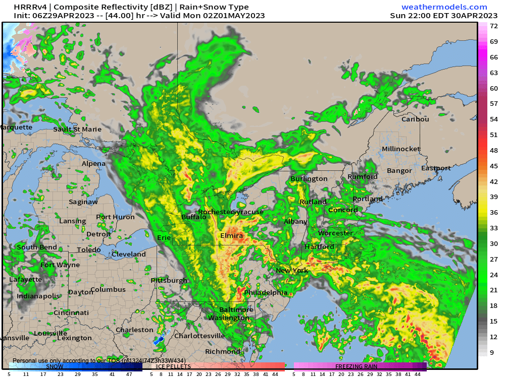
Heaviest rain Sunday night
~~~~~~~~~~~~~~~~~~~~~~
A NOTE FROM OUR SPONSOR:
Dave Hayes The Weather Nut is Sponsored by Individual Community Members, Patrons & Red Fire Farm. The Red Fire Farm store is open daily at 7 Carver Street in Granby, MA, and if you are looking for delicious organic produce, join their Summer CSA farm share. Vibrant greens, luscious heirloom tomatoes, sweet carrots and lots more to enjoy. Shares get free Pick Your Own, kicking off with strawberries in June. Add pastured eggs, local fruit & cheeses, mushrooms, pantry items, bouquets of organic flowers, and more. Weekly pickups at the Granby farm, Montague, Amherst, Forest Park/Springfield, Northampton, & Worcester (plus home delivery available), so click here today and snag your Summer Share!
~~~~~~~~~~~~~~~~~~~~~~~~~~~~~~~~
SIGNALS OF PATTERN CHANGE TO DRIER BY NEXT WEEKEND
I thought I would do everyone a solid and float that bit of potential good news early in this report, as the next 7 days are not looking dry in the aggregate, nor mild/warm.
For today, rainfall has already moved in to parts of the region, which is earlier than I expected yesterday morning, and I was traveling yesterday afternoon/evening so didn’t have time to update.
We still have high pressure nosing in some drier air from the east, which will help tamp rain totals in CMass, eastern SWNH, and northeast CT, with steadier/heavier rain in SVT, WMass and northwest/central CT.
That dry air may bleed into extreme eastern parts of WMass as well.
In those drier areas, a half inch or less of rain is expected, otherwise over half an inch to even over an inch looks likely in western areas through midnight tonight.
Highs today will only reach the upper 40s to low 50s or so in SVT, WMass and northwest CT, but more like mid to even upper 50s in CMass and northeast CT.
If the inversion can be overcome, east winds may gust 15-30mph today and tonight, although best chance for that is at elevation.
Lows tonight will drop to the low to mid 40s as more rain moves in with a second wave working through our region.
By Sunday morning we should see the bulk of showers from this second wave lifting northeast and away.
This would give us a break in the steadier rains, though a few showers are still possible.
It will be milder with highs in the 55-60º range.
Then, our final and strongest low pressure system runs south to north into our region, bringing rain, heavy at times with a few thunderstorms Sunday later afternoon and night, ending before dawn on Monday morning.
This is also when the strongest winds are expected, and gusts out of the east of 25-40mph are possible with lows in the 45-50º range with patchy fog.
This whole complex rips north and the dry slot moves in for Monday with strong southerly flow and highs possibly reaching into the upper 60s, depending how much sunshine we can develop.
No matter, because another dopey upper low will meander about the Great Lakes for most of next week, producing periods of showers each day, with the heavier ones capable of producing pockets of hard hail (i.e. regular hail) or soft hail (i.e. graupel, or ice-encased snowflakes).
Highs will be in the upper 40s to mid 50s in the high terrain next week, with more like mid to upper 50s in the valley points south and east.
There IS a signal for drier and milder conditions to start developing next weekend, so hang in there and I will keep you updated!
Be well, make soup, have a great day.
BE KIND
“Hello babies. Welcome to Earth. It’s hot in the summer and cold in the winter. It’s round and wet and crowded. On the outside, babies, you’ve got a hundred years here. There’s only one rule that I know of, babies: Goddamn it, you’ve got to be kind.”
–Kurt Vonnegut
