————-
HELP KEEP DHTWN ON THE JOB IN 2023
————-
Good morning everybody, there are reports of sleet and snow mixed with sleet out in NY state which is where our weather is coming from today.
We’ve got fairly dry surface conditions, and cold temps this morning, and it’s cold up into first 1-2 miles, and milder air surging in around that 2-mile aloft level.
A potent storm system is going to rip northeast through Lake Huron, staying WELL west of us, and the secondary low will likely not really get going until it’s into the Gulf of Maine, so that leads me to believe that we’ll be going from a wintry mix and rain start by late morning to early afternoon (again snow/sleet is mainly N of Rt. 2 and in our region’s high terrain above 1000 feet, though could mix in the valley at first before rain) to more of a rainy finish with some freezing rain in the high terrain by late afternoon and early evening.
A dry punch of air should be working northeast into the region by around sunset or early evening, and then a final convective band of heavier showers with some icing sweeps through as we get towards midnight.
Again, some high terrain/northernmost areas should see some light ice accretion, and a coating to up to 2″ of snow/sleet in the highest peaks, but high March sun angle, marginal temps, and milder air aloft should all combine to make this more of a raw, rainy day with some echoes of the departing winter season thrown in for good measure.
Still, watch for slippery spots in the usual locations, please.
As the storm tracks well northwest of us, we’ll get southeast winds developing in the late afternoon and evening that will gust 20-30mph in most areas, but up to 30-45mph in far northweast MA and southern VT, where Wind Advisories have been hoisted.
Highs will reach the mid to upper 30s today (some low 30s in the high terrain areas where ice glaze is expected) with lows in the low to mid 30s as everything winds down after midnight.
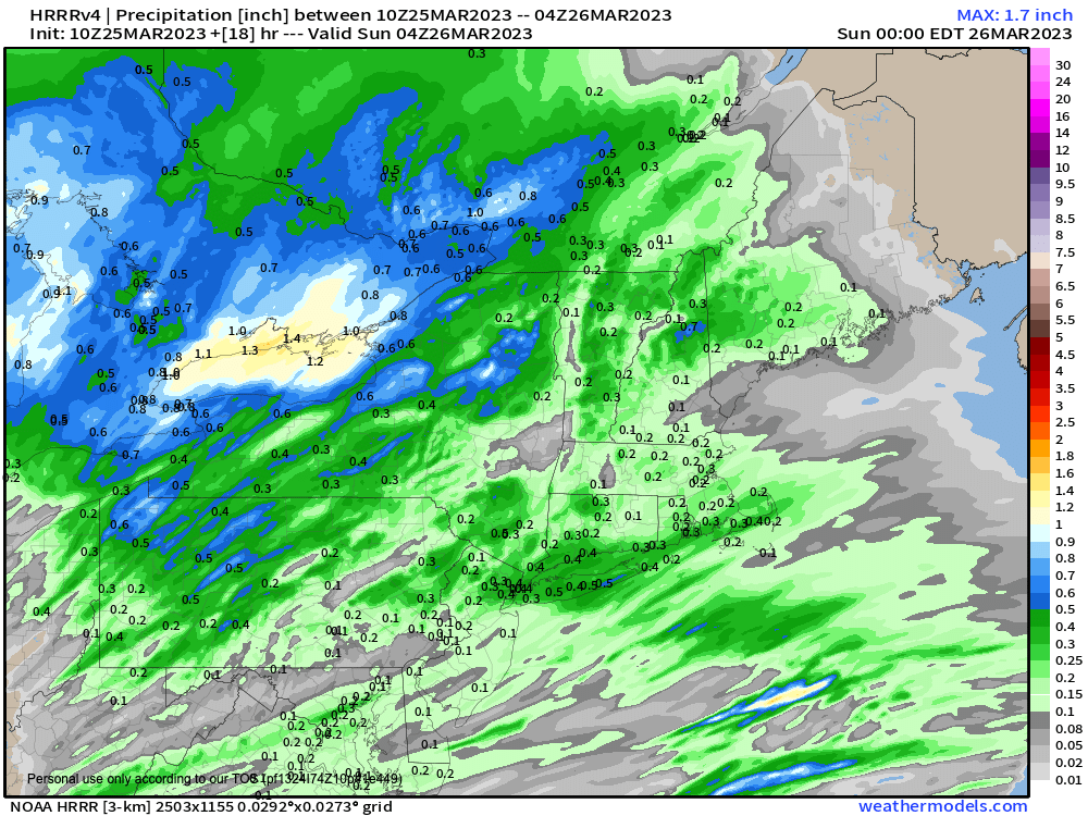
Lastly, as you can see in the attached chart, this has trended with less precipitation because the storm is farther west, and the bands that move through this afternoon look to be more strung out.
That last convective band later tonight could tip the scales to heavier rain, but I will update you later.
Southeast wind gusts will shift around to the northwest for Sunday and gust 25-35mph under partly sunny skies with highs in the mid 40s to low 50s, and lows near freezing.
Monday looks gorgeous with less wind, sunny skies, and highs in the mid 40s to low 50s, which leads us into a potentially more unsettled pattern Tuesday and Wednesday.
As I watch these signals, it’s hard to see that period becoming more than periods of scattered rain or snow showers, as southern energy does not phase with northern energy, with both system sliding about due east and out to sea, but I will keep you updated.
I will post again around mid-day and again late afternoon with updates on today’s raw weather.
Have a great day, and my 2023 Support Drive ends tomorrow. I’m still short of my goal, but getting closer and if you can chip in even a modest amount (whatever you’re able to) I’m confident we’ll get there, as I hope to continue through this year and beyond (click secure link below, and thank you).
————-
HELP KEEP DHTWN ON THE JOB IN 2023
————-
