
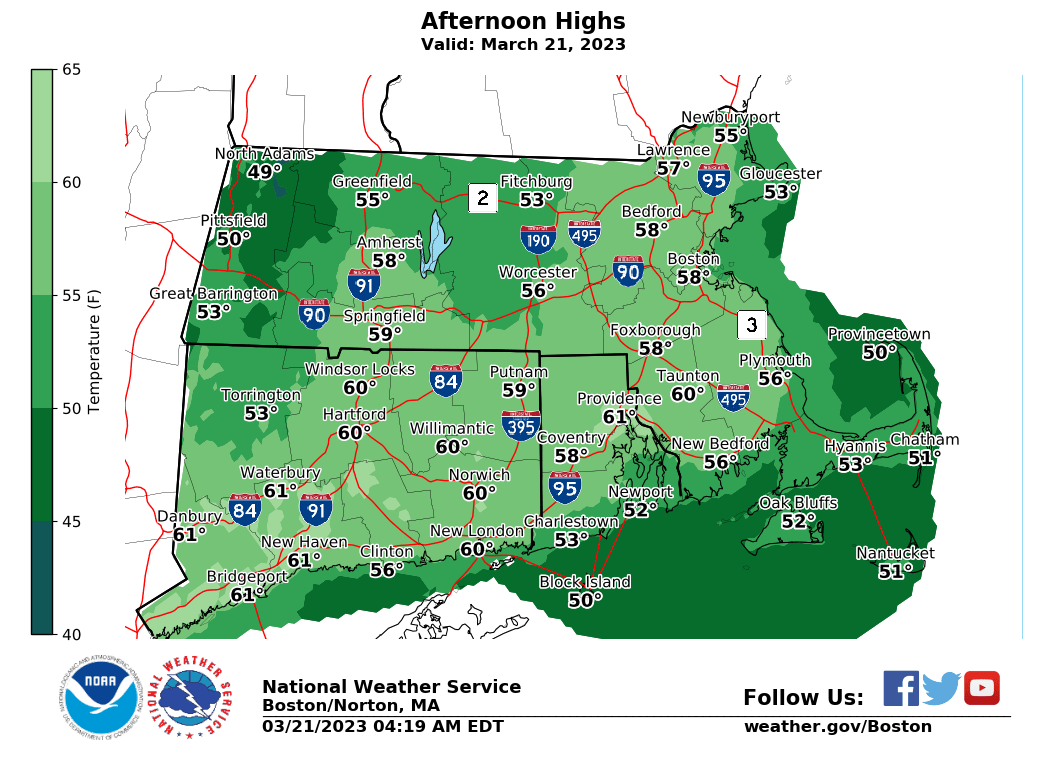
High Temps Tuesday
I HOPE SO, AND IF SO I’M ASKING FOR YOUR HELP TODAY TO REACH MY 2023 SUPPORT GOAL BY *THIS* SUNDAY TO SUSTAIN MY WORK IN 2023:
DETAILS
–> My Goal is 4% of fans (1 in 25) donating any amount
–> My Goal Progress = 54% have stepped up w/ 5 days left
–> Any member level or support amount is appreciated
–> Your investment in my work sustains it forward
–> Please click the secure link below to select for options:
–> SecureCLICK
–> Thank you!
——————-
TABLE OF CONTENTS:
–DHTWN Reminder (Be Nice)
–Weekly Nutshell (Quick impact list)
–Sponsor Note (Tandem Bagel Co.)
–NWS Alerts (Advisories, Warnings, Watches)
–Celestial Data (Sun/Moon info)
–Regional Summaries (Quick in/out details)
–Morning Discussion (More Details)
~~~~~~~~~~~~~~~~~~~~~~
DHTWN REMINDER: It doesn’t take much to do a nice thing for somebody that you don’t know.
~~~~~~~~~~~~~~~~~~~~~~
DAVE’S WEEKLY WEATHER NUTSHELL
–Risk of elevated fire spread today where snow pack is gone
–Partly to mostly sunny, highs 50s
–West winds gust 15-25mph, partly cloudy tonight
–Wednesday starts off partly sunny, clouds build later
–A few showers late Wednesday night into early Thursday
–More showers by afternoon into the early evening, mild
–Cloudy on Friday, mild with a cold front coming through
–Saturday is much colder behind the front, with another storm by afternoon
–Rain in the valley and snow/ice possible in the Berkshires, western hilltowns and up into SVT, SWNH, and northern CMass
–Light to perhaps even moderate wet snow accumulationspossible by Sunday morning
–A few snow showers possible Sunday with another system by Monday night into Tuesday capable of more high-terrain snow, but before we jump into the weather discussion/details below, let’s check a note from our local and delicious sponsor, #TandemBagelCo, with their newest location in West Springfield, MA.
~~~~~~~~~~~~~~~~~~~~~~
A NOTE FROM OUR SPONSOR:
Dave Hayes The Weather Nut is Sponsored by Individual Community Members, Patrons & Tandem Bagel Company… No matter the weather, Tandem Bagel is always there for you at several valley locations to make your mornings brighter! With bagels baked fresh daily (including Gluten-Free options), house-whipped cream cheese, coffee, and tons of lunch options, Tandem is the perfect quick stop for lunch, breakfast, or a coffee and bagel to go. Find them in Easthampton, Northampton, Hadley, Florence, and West Springfield, or use their super-streamlined online ordering tool by visiting their website.
~~~~~~~~~~~~~~~~~~~~~~~~~~~~~~~~
***DHTWN DAILY WEATHER REPORT***
~~~~~~~~~~~~~~~~~~~~~~~~~~~~~~~~
NATIONAL WEATHER SERVICE ALERTS
–None, but elevated fire conditions are noted where snow pack has melted in the lowlands of southern New England, given very dry conditions, sunshine, and gusty southwest winds today.
DAILY CELESTIAL (STAR):
–OUR STAR ROSE AT: 6:52am this morning
–OUR STAR WILL SET AT: 7:03pm this evening
–TOTAL DAYLIGHT TIME: 12 hours and 11 minutes
NIGHTLY CELESTIAL (MOON):
–OUR MOON WILL SET AT: 7:10pm this evening
–OUR MOON WILL RISE AT: 7:28am tomorrow morning
–MOON SET DIRECTION: West
–MOON RISE DIRECTION: East
–MOON PHASE: New Moon (0.0%)
~~~~~~~~~~~~~~~~~~~~~~~~~~~~~~~~
DAILY TERRESTRIAL
ZONE 1 – Northern Region
(Southern VT, Southwest NH)
–High Temps: Mid 40s to Low 50s
–Low Temps: Upper 20s to Low 30s
–Winds: Westerly winds gust 15 to 25mph
–Sky Cover: Partly to Mostly Sunny
–Precipitation: Dry
ZONE 2 – Central Region
(Western MA, North-Central MA, Northern Litchfield CT)
–High Temps: Low to Upper 50s
–Low Temps: Low to Mid 30s
–Winds: Westerly winds gust 15 to 25mph
–Sky Cover: Partly to Mostly Sunny
–Precipitation: Dry
ZONE 3 – Southern Region
(South-Central MA, Northern CT)
–High Temps: Mid 50s to Low 60s
–Low Temps: Mid 30s
–Winds: Westerly winds gust 15 to 25mph
–Sky Cover: Partly to Mostly Sunny
–Precipitation: Dry
~~~~~~~~~~~~~~~~~~~~~~~~~~~~~~~~
LET’S STAY CONNECTED
Visit this page on my website on Staying Connected
~~~~~~~~~~~~~~~~~~~~~~~~~~~~~~~~
MORNING DISCUSSION
Good morning everybody, we have an extremely delicious day ahead with temps soaring into the 50s, with some folks hitting the low 60s south of the Pike! Woo!
This won’t last past this week in the short run, but it’ll be a nice taste of Spring weather to come.
Fortunately for the high terrain with deep snow pack, the temps will tamp back down by this weekend into next week, which will help slow The Meltening, and perhaps attenuate The Muddening, although I’m unsure if prolonging mud season is better or worse, and I’m sure hilltowners can weigh in on that score.
For today, we’ll see some clouds at times, but on average it looks partly to mostly sunny with highs well into the 50s, and a west wind will gust 15-25mph at times.
For tonight, a partly cloudy evening arrives with lows in the upper 20s to mid 30s region-wide (lower range temps are always at elevation and further north and west you go, upper range temps are always at low elevations and further south and east you go).
Wednesday will turn out to be a lovely day, too, with highs in the mid to upper 50s under partly sunny skies, but clouds will build some more late afternoon and evening as an upper trough swings into the Great Lakes. Lows will drop to either side of 40º.
This will send a surface low to our north for Thursday, which will gently fling its warm front through the region, which will create a couple periods of scattered showers.
The first period arrives early Thursday morning, but a larger area of showers moves through in the afternoon and evening. Highs will reach the 50s with lows near 40º.
We can’t rule out a few showers on Friday either, but it looks a bit drier, but still mostly cloudy with highs in the upper 40s to low 50s with lows near freezing.
Saturday and Saturday hold wintry potential, folks, especially for high elevation areas above 1000 feet.
A primary low pressure system will push east-northeast into the eastern Great Lakes and spawn a secondary low off of the southern England coastline.
These do not look like potent lows, or ANYTHING like what we just had a week ago!
But, we could see some valley rainfall with mixed snow, and accumulating snow in the Berkshires, western hilltowns, northern CMass, eastern Franklin County highlands into SVT/SWNH starting Saturday mid-day and lasting into Saturday night.
We’ll have to see which low weakens and/or deepens more quickly than the other, and of course this time of year, timing of arrival is huge, and this one comes likely during the day, which puts a dent in the ability to get accumulations.
Still, we can’t rule out 1-4″ of snow and sleet somewhere in the region, so stay tuned for updates!
Sunday could see a few snow showers, cool, and early next week more inclement weather is possible, and could also produce a bit of wintry precipitation in the hilltowns.
“I am a builder from Chicopee. We depend on accurate forecasts to feed our families. The weather dictates when we start a project, what work we’ll do, and our scheduling. You are my go-to guy for weather. I will happily support your work in the same manner in which you help to support mine, thank you.” –Rich R.
–> Your Contributions Today Help Sustain this Community Weather Resource
–> CLICK
BE KIND
“Hello babies. Welcome to Earth. It’s hot in the summer and cold in the winter. It’s round and wet and crowded. On the outside, babies, you’ve got a hundred years here. There’s only one rule that I know of, babies: Goddamn it, you’ve got to be kind.”
–Kurt Vonnegut