
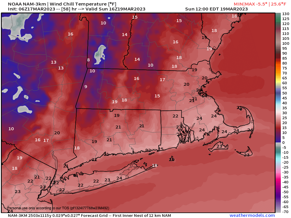
Wind chills in the teens Sunday
–> My Annual Support Goal = 4% of readers (1 in 25) donating any amount
–> 2023 Goal Progress = about halfway there
–> 2023 Member Drive ends 3/26
–> I’m still well short of my 4% reader goal
–> Any member or support level is appreciated
–> SecureSupportCLICK
———————-
Good morning everybody, aside from a few scattered rain or snow showers over the next 60 hours, along with a notable cold snap Saturday night into Sunday night that will produce a blustery and cold Sunday with wind chills into teens for some, we generally have fairly fair weather coming up over the next 6-7 days, so that’s good after our late-season nor’easter that still has over 5000 households without power in Windham County, VT.
Before we continue with our upcoming weather details, let’s check a note from our Local Sponsor
~~~~~~~~~~~~~~~~~~~~~~~~~~~~~~~~
Dave Hayes The Weather Nut is Sponsored by Individual Community Members, Patrons & Tandem Bagel Company… No matter the weather, Tandem Bagel is always there for you at several valley locations to make your mornings brighter! With bagels baked fresh daily (including Gluten-Free options), house-whipped cream cheese, coffee, and tons of lunch options, Tandem is the perfect quick stop for lunch, breakfast, or a coffee and bagel to go. Find them in Easthampton, Northampton, Hadley, Florence, and West Springfield, or use their super-streamlined online ordering tool by visiting their website.
~~~~~~~~~~~~~~~~~~~~~~~~~~~~~~~~
Moving forward, clouds will be increasing today with a few peeks of sunshine as high pressure passes to our south. Highs will reach the mid 40s to low 50s, though likely stay down in the low 40s in high snow pack areas.
A warm front works into the region later today along with a few scattered showers, but nothing of consequence is expected.
Lows will drop into the upper 20s to mid 30s overnight with a rain or snow shower possible.
For Saturday, a cold front works through early and then mostly sunny skies develop with cold air lagging into night time into Sunday.
Highs will be well into the 40s with westerly breezes.
As a weak wave moves through Saturday night, cold air is ushered into the region, along with a few snow showers into Sunday morning.
Lows will be quite cold, down into the upper teens to mid 20s, and west winds will pick up behind this wave, gusting to 30mph.
On Sunday, it’ll be one-day cold snap for mid-March standards, with highs only in the upper 20s to mid 30s!
Also, west winds are expected to pickup and gust to 45mph, which may spark a few additional isolated outages, and is expected to produce wind chills in the upper teens and 20s across the region.
Blustery conditions will continue Sunday night with lows either side of 20º.
Thereafter? The Mildening, Meltening and Muddening commences.
For now, it looks like fair weather will build into the region with sunshine, highs in the 40s and 50s, and lows down near 30º through mid-week.
There are some hints at late-week storminess, but it’s too early to have any clarity at this point.
Have a great day, and if you rely on my work here, I need your support. Please contribute to my annual support drive before 3/26 so I can continue this daily local weather reporting service throughout 2023, thank you.
———————-
BECOME A 2023 MEMBER / SUPPORTER BELOW(Options include Cards, PayPal, Venmo, or Check)