
SECURELY BECOME A 2023 MEMBER OR SUPPORTER AT ANY LEVEL TODAY(Options include Cards, PayPal, Venmo, or Check)
~~~~~~~~~~~~~~~~~~~~~~
Good morning everybody, we’ve got varying amounts of wet snow accumulations across the region, including 4.5″ in Tolland County in northeast CT, 4″ in Florence, 8″ or so in Windsor, MA, almost 4″ in Fitchburg, but please let me know how much you have and where you are!
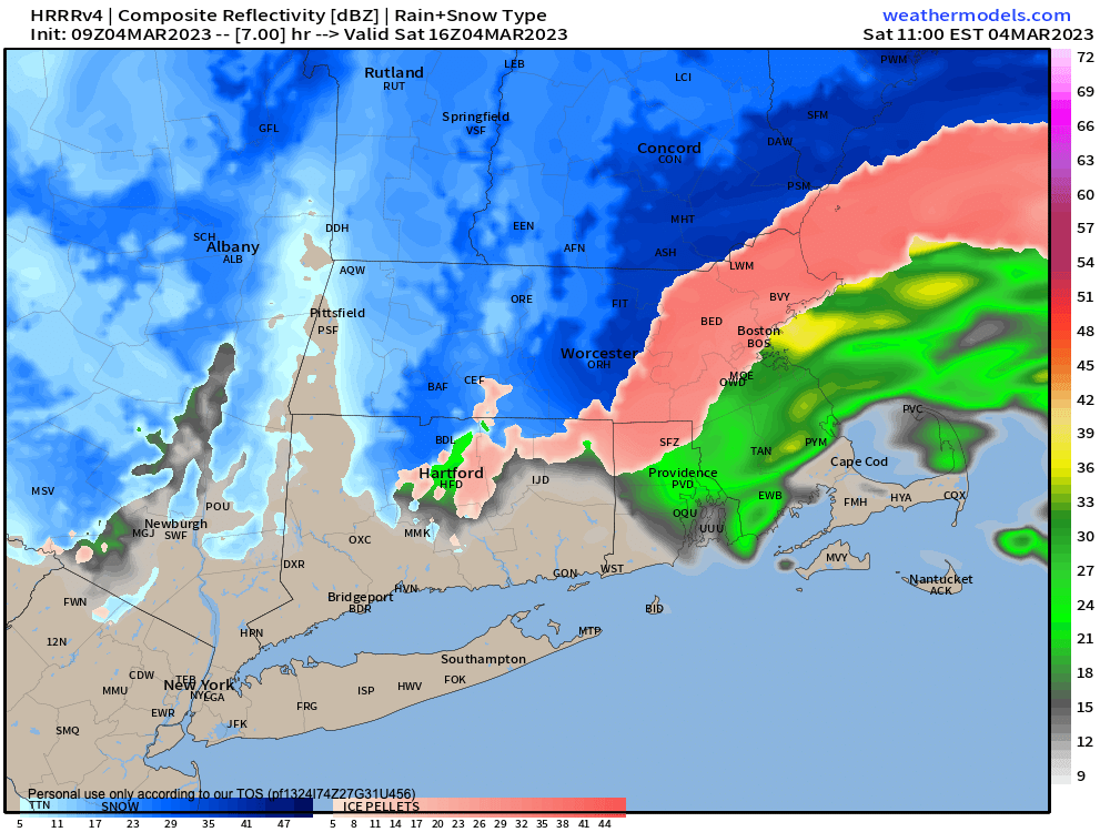
Our secondary low has formed into a 990mb system south of Long Island which will deepen a little more as it tracks east towards Martha’s Vineyard and Nantucket, and pulling colder air in from northwest to southeast through the WMass region, changing just about everybody to snow who is icing currently (or even raining in central/southern CT).
The mid-level jet streak that had the potential to push milder air into the MA/VT-NH state line failed to do so en masse, so no sleet storm developed after midnight well north of the Mass Pike.
Southern VT has close to 1000 outages, mostly in eastern Bennington County where easterly gusts to 40mph combined with heavy wet snow and knocked out power for some folks, as I had mentioned.
BE CAREFUL removing snow today, it is heavy and wet, so take your time, and take breaks.
The primary low is weakening in NY state and will merge with the western flank of the secondary low as it pulls away, and this merging will push a final band of light to moderate snow and sleet east from NY through WMass this morning, which is already occurring, causing an earlier lull to fill back in, mostly along and north of the Pike in the Berkshires, Hampshire and Franklin Counties and SVT and SWNH, with CMass getting in on the act later.
~~~~~~~~~~~~~~~~~~~~~~
SECURELY BECOME A 2023 MEMBER OR SUPPORTER AT ANY LEVEL TODAY(Options include Cards, PayPal, Venmo, or Check)
~~~~~~~~~~~~~~~~~~~~~~
Northern CT should be more showery as drier air worked in down there, so little additional accumulation is expected.
This morning and afternoon activity should bring an additional coating to 3″ or so (less in the valley, more in the high terrain) by noon, and then we should be winding things down through the afternoon (I will post last night’s thoughts for snow accumulations through this evening at the bottom of this post).
Highs today will reach the low to mid 30s with scattered snow showers quitting between mid afternoon to early evening from west to east, with lows tonight in the mid 20s with patchy fog possible.
Seasonable temperatures are expected Sunday and Monday with a return to sunshine!
Sunday looks partly sunny and Monday looks mostly sunny as high pressure builds through and northwest gusts could blow up to 30mph at times with highs in the upper 30s to low 40s both days and lows in the upper 20s.
Clouds increase Monday night, and then we’ll have to watch a southeasterly-diving Clipper low that may bring some snow showers or a period of light snow to parts of our region late Monday night into Tuesday.
After that, colder highs in the 30s move in with northwest flow, but while it looks like we’ll see more clouds than sun, no significant precipitation is expected, and sunshine should return by Friday.
Then we watch next weekend with a powerful coastal storm possible, and it could be wintry by next Sunday, so stay tuned for updates!
Have a great day, I will update again around mid-day as the storm starts to wind down, and if you appreciate and value my work, please consider supporting it via my 2023 Member/Support Drive… any monthly or one-time amount is helpful, thank you:
2023 MEMBER/SUPPORT DRIVE SECURE LINK
AMOUNTS FROM LAST NIGHT
I’d say my confidence is moderate, certainly not high with these amounts, but this is my best idea/thinking around accumulations
2-5″
I am going to leave the ranges the same, that being 2-5″ in northern CT up to the level of Rt. 2 in MA.
I think the further south you go, amounts could drop off quickly and if this mid-level jet roasts aloft, some areas in northern CT will see under 2″.
I think that once you get north of the Pike, my 2-5″ range, if anything, could be low, so lean to the upper half of this range north of the Pike, which includes snow and sleet, and don’t be surprised if some of you get more than 5″ or more.
5-10″
Along and north of Rt. 2 I am sticking with 5-10″, but also here it’s more probable than not that amounts will be in the upper half of that range
Also, while the eastern Berkshires and many western hilltowns, along with parts of southeast Franklin County and northern CMass are south of Rt. 2, I think those areas I just mentioned should see 5-10″ as well.
8-14″
As I mentioned in an previous posts, parts of the northwest hjiltowns (northwestern Hampshire like Cummington and Plainfield, and western Franklin County at elevation) and southern VT could see more like 8-14″.