
GET CONNECTED – You get the continued cultivation of a local and regional online community around severe weather events.
Keep DHTWN In Your Service (drive ends 3/26)
WEATHER REPORT
Good morning everybody, we have a very busy pattern coming up, and while we’ll rise into the milder side through Monday (when temps peak), our temperatures are going to be coming DOWN through the week into next weekend as multiple waves of low pressure systems make their way into our region.
For today, we have a weak shortwave and warm front moving into the region with strong high pressure to our south tracking offshore, and a stronger low pressure system north of Lake Superior heading northeast.
This will increase a pressure gradient across the region, as well as thicken the cloud deck with highs in the mid to upper 40s on southerly wind gusts up to 25mph this afternoon with incoming mild flow.
Tonight, it should continue to be breezy but nothing crazy, and lows will dip to the low to mid 30s under mostly cloudy skies.
For Monday, the first and weakest system in our developing active pattern moves through the region in the form of a cold front.
With increasing humidity overnight, some patchy fog is possible early, and then we should see a mostly cloudy day with highs in the mid 40s to low 50s (the mildest we’ll see in probably a week). A few rain showers will move through during the late morning to afternoon, and then quit with colder lows in the mid to upper 20s behind the front.
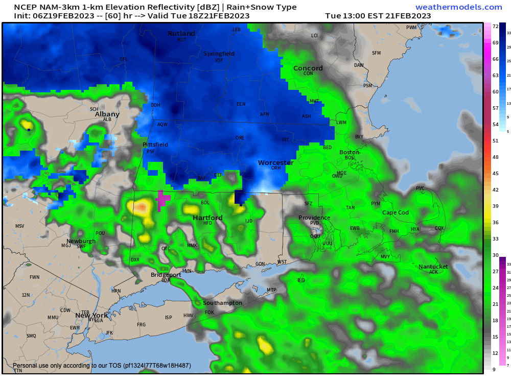
For Tuesday, a more robust Clipper system looks to pass north of us, and will bring mixed rain and snow showers into the region with highs in the mid 30s to mid 40s.
It is possible that a dynamically-cooled burst of snow could form along and north of the Rt. 2 corridor later in the afternoon and produce some light snow accumulations so I will keep an eye on that.
——————-
KATIE VOTED “YES” – YOU?
“I don’t know what I’d do without Dave! This is one of the best services and best websites to have…we are so lucky! Up to the minute reporting and details really help, and Dave is very funny too. Thanks Dave!” –Katie
–> Your Contributions Today Help Sustain this Community Weather Resource
–> Click this secure link to select from many support options, thanks!
——————-
Otherwise any rain or snow showers will quit at night as the cold front swings through, and west winds may gust up to 35mph as temps drop into the 20s once again, producing a blustery overnight period.
The first part of Wednesday looks dry and partly sunny as high pressure nudges into the region for a minute, with highs in the mid 30s to low 40s.
However, a very complex system of upper level systems and a surface low along an extended boundary between increasing cold to the north, and mild air to the south will lift toward New England at night.
This will likely result in a burst of snow to start Wednesday night as lows drop into the upper 20s.
However, mild air is expected to surge northeastward aloft, while cold air continues at the surface to drain southward. Highs on Thursday should be hovering around freezing, and possibly dropping below freezing later in the day, especially north of the Pike.
It is possible some areas in northern CT turn to plain rain for a time.
The bottom line is that this is a set up for a potential ice storm with plenty of sleet and freezing rain for an extended period of time, which now has me concerned for the Thursday morning commute, and all of Thursday and Thursday night, for that matter.
Hazardous travel may develop with prolonged icing, that may last into early Friday, so please stay tuned for updates on this wintry system.
Friday should turn into a drying day, but a cold front will drop through the region, and it will turn much colder and blustery/windy with lows crashing into the teens at night!
This sets us up for a weekend storm that depending where it tracks could bring accumulating snowfall to the region, but it’s way off, and there are potentials for a snow to rain result as well, so it’s something to monitor.
In addition, there are signals for ANOTHER storm with wintry potential the following Tuesday/Wednesday, so that makes 5 potential systems of inclement weather (some of it wintry) in the next 9 days.
Have a great day, and remember…
PLANTS THAT WE WATER KEEP FLOWERING
When 4% of my readers “water” my work with even $5 or 10/year, $2/month (or more if you’re able) I can remain in your service throughout 2023.
—-> A major storm likely put me on your radar in the past
—-> Despite a mild Winter, this is New England
—-> Whether our weather’s Mild or Wild, it will eventually turn
—-> When it does, I want to show up for you and yours
That’s why I’m asking you to join my 2023 Support Network today as a Member or as a Supporter by clicking this secure link, before my Member Drive ends 3/26/23.
Thank you!!