
TABLE OF CONTENTS:
–Weekly Nutshell (Quick impact list)
–Sponsor Note (Tandem Bagel Co.)
–NWS Alerts (Advisories, Warnings, Watches)
–Celestial Data (Sun/Moon info)
–Regional Summaries (quick in and out details)
–Morning Discussion (Longer-form explanation)
~~~~~~~~~~~~~~~~~~~~~~
DAVE’S WEEKLY WEATHER NUTSHELL
–Morning sunshine gives way to increasing clouds by mid-day into the afternoon
–Very mild highs in the 50s and 60s today, breezy at times
–Scattered showers arrive by late afternoon into the early evening
–Patchy fog and isolated showers overnight, mild
–A cold front sweeps the region by early afternoon Friday, leading to southerly wind gusts over 20mph ahead of it, and periods of showers
–Can’t rule out a thunderstorm sometime around mid-day with the front, very mild, then temps fall during the day
–Rain showers may change to sleet and snow showers later afternoon into the evening as temps drop to the teens overnight
–Lovely weekend ahead, colder and sunnier Saturday in the 30s, milder and more partly sunny on Sunday in the 40s
–Several periods of mild rain showers Sunday night into Tuesday, then colder by mid to late week with winter weather possible, but before we jump into the weather discussion/details below, let’s check a note from our local and delicious sponsor, #TandemBagelCo, with their newest location in West Springfield, MA.
~~~~~~~~~~~~~~~~~~~~~~
A NOTE FROM OUR SPONSOR:
Dave Hayes The Weather Nut is Sponsored by Members, Patrons & Tandem Bagel Company… No matter the weather, Tandem Bagel is always there for you at several valley locations to make your mornings brighter! With bagels baked fresh daily (including Gluten-Free options), house-whipped cream cheese, coffee, and tons of lunch options, Tandem is the perfect quick stop for lunch, breakfast, or a coffee and bagel to go. Find them in Easthampton, Northampton, Hadley, Florence, and West Springfield, or use their super-streamlined online ordering tool by visiting their website.
~~~~~~~~~~~~~~~~~~~~~~~~~~~~~~~~
***DHTWN DAILY WEATHER REPORT***
~~~~~~~~~~~~~~~~~~~~~~~~~~~~~~~~
NATIONAL WEATHER SERVICE ALERTS
–Zilch.
DHTWN REMINDER
–It doesn’t take much to do a nice thing for somebody that you don’t know.
DAILY CELESTIAL (STAR):
–OUR STAR ROSE AT: 6:45am this morning
–OUR STAR WILL SET AT: 5:24pm this evening
–TOTAL DAYLIGHT TIME: 10 hours and 39 minutes
NIGHTLY CELESTIAL (MOON):
–OUR MOON WILL SET AT: 12:45pm this morning
–OUR MOON WILL RISE AT: 5:12am tomorrow morning
–MOON SET DIRECTION: Southwest
–MOON RISE DIRECTION: Southeast
–MOON PHASE: Waning Crescent (20.4%)
~~~~~~~~~~~~~~~~~~~~~~~~~~~~~~~~
DAILY TERRESTRIAL
ZONE 1 – Northern Region
(Southern VT, Southwest NH)
–High Temps (Today): Upper 40s to Mid 50s
–Low Temps (Tonight): Low to Mid 40s
–High Temps (Tomorrow): Upper 40s to Low 50s
–Winds: Fairly light today, southerly tomorrow later morning into afternoon, then northwest later Friday, gusts 20-35mph
–Sky Cover: Sunshine early then increasing clouds, cloudy into Friday
–Precipitation: Showers by late afternoon to early evening, a lull to isolated showers overnight, then more numerous showers later Friday morning into afternoon, changing to snow/sleet
ZONE 2 – Central Region
(Western MA, North-Central MA, Northern Litchfield CT)
–High Temps (Today): Low 50s to Low 60s
–Low Temps (Tonight): Mid 40s to low 50s
–High Temps (Tomorrow): Mid to Upper 50s
–Winds: Fairly light today, southerly tomorrow later morning into afternoon, then northwest later Friday, gusts 20-35mph
–Sky Cover: Sunshine early then increasing clouds, cloudy into Friday
–Precipitation: Showers by late afternoon to early evening, a lull to isolated showers overnight, then more numerous showers later Friday morning into afternoon with thunder possible… could with or changing to snow/sleet in northwest areas
ZONE 3 – Southern Region
(South-Central MA, Northern CT)
–High Temps (Today): Low to Mid 60s
–Low Temps (Tonight): Mid to Upper 40s
–High Temps (Tomorrow): Mid to Upper 50s
–Winds: Fairly light today, southerly tomorrow later morning into afternoon, then northwest later Friday, gusts 20-35mph
–Sky Cover: Sunshine early then increasing clouds, cloudy into Friday
–Precipitation: Showers by late afternoon to early evening, a lull to isolated showers overnight, then more numerous showers later Friday morning into afternoon with thunder possible
~~~~~~~~~~~~~~~~~~~~~~~~~~~~~~~~
MORNING DISCUSSION
Good morning everybody, we’ve got a nice morning to start our Thursday, but clouds will be building into the region as the morning wears into the afternoon.
Chilly valley temps are flanked either side by mild temps in the Berkshires and Worcester hills, but all temps should be coming up into the 50s and 60s, with some folks south of the Pike reaching the mid 60s for highs!
After some northwest breeze, wind will shift and become light southerly overnight as clouds this afternoon lead to periods of showers arriving late afternoon into early evening.
After a burst of showers, we should see the precip shield break up and produce more isolated or widely scattered showers with patchy fog possible, increased humidity, and lows in the 40s to low 50s.
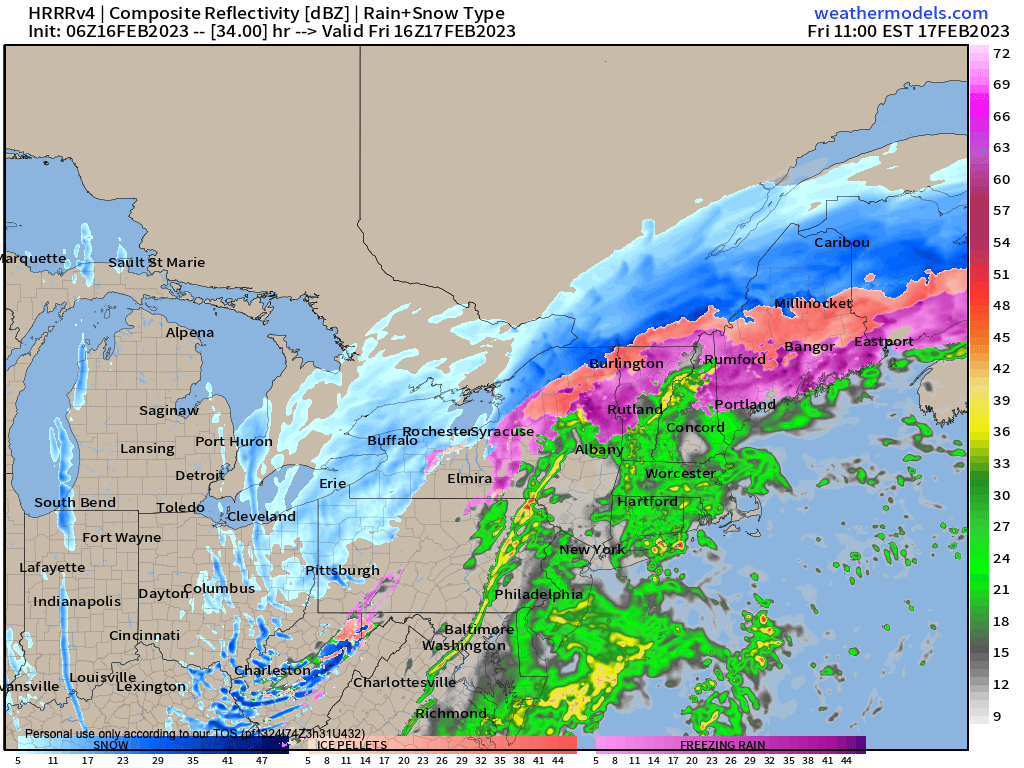
By Friday morning, a cold front will be slicing through New York state, heading east toward New England. A mostly cloudy day is expected.
This boundary will help develop more numerous out ahead of it Friday morning, and the rain may fall heavily. In fact, we can’t rule out a thunderstorm as the front careens into milder air, with highs rising well into the 50s Friday.
Southerly gusts will blow to 25mph at times, and the front should move through by early afternoon when some thunder is possible.
Behind the front we’ll see a shift of wind around to the northwest and it could gust up to 35mph at times as temps plummet.
In addition, by mid-afternoon we should see some final showers turning to snow or sleet, especially along and north of Rt. 2, but it could happen in the valley as well.
Lows will crash into the teens to low 20s overnight with a blustery night ahead.
The weekend looks good, with Saturday being the chillier pick, with highs in the 30s under mostly sunny skies, and lows in the 20s. Sunday looks milder, with highs in the 40s as high pressure tracks south of us, but clouds will also be increasing into the evening.
Several disturbances and/or frontal boundaries will keep the chance for scattered showers into the greater WMass region for late Sunday night into early next week, so I will have to refine that as we get closer, though temps do like mild in this period (though not as mild as today and tomorrow).
By mid to late next week, colder air will be nearby and I’ll be watching potential for a storm that may have some wintry impacts, so stay tuned.
Have a great day!
Let’s Stay Together (click for options).
Join my Free Weekly Nutletter (click to join).
Follow me on Twitter (click to follow).
AND REMEMBER…
“Hello babies. Welcome to Earth. It’s hot in the summer and cold in the winter. It’s round and wet and crowded. On the outside, babies, you’ve got a hundred years here. There’s only one rule that I know of, babies: Goddamn it, you’ve got to be kind.”
–Kurt Vonnegut