
Windy later today
–Weekly Nutshell (Quick impact list)
–Sponsor Note (Tandem Bagel Co.)
–NWS Alerts (Advisories, Warnings, Watches)
–Celestial Data (Sun/Moon info)
–Regional Summaries (quick in and out details)
–Morning Discussion (Longer-form explanation)
~~~~~~~~~~~~~~~~~~~~~~
DAVE’S WEEKLY WEATHER NUTSHELL
–A warm front moves through with an isolated shower possible, otherwise cloudy morning becoming sunny
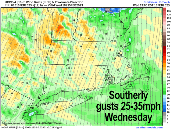
–Highs rise well into the 50s, southerly gusts 25-35mph
–Lows tonight only in the 40s with lighter westerly wind
–Highs reach the mid 50s to low 60s as clouds increase Thursday with a light west wind during the day
–Showers arrive by later afternoon into early evening, possible lull at night before more showers into early Friday morning, thunder possible
–Southerly wind gusts pick up Thursday night to 30mph
–Then a cold front passes through Friday morning, highs in the morning in the 50s crash through the day
–Northwest winds gust 25-40mph into Friday night with lows in the teens, a few snow showers possible
–Saturday is sunny with highs in the mid to upper 30s and lows in the 230s
–Sunday is milder, sunny, highs 40s, lows near freezing
–Milder early next week, but the pattern may be changing with a potential for winter weather by mid to late next week, but before we jump into the weather discussion/details below, let’s check a note from our local and delicious sponsor, #TandemBagelCo, with their newest location in West Springfield, MA.
~~~~~~~~~~~~~~~~~~~~~~
A NOTE FROM OUR SPONSOR:
Dave Hayes The Weather Nut is Sponsored by Members, Patrons & Tandem Bagel Company… No matter the weather, Tandem Bagel is always there for you at several valley locations to make your mornings brighter! With bagels baked fresh daily (including Gluten-Free options), house-whipped cream cheese, coffee, and tons of lunch options, Tandem is the perfect quick stop for lunch, breakfast, or a coffee and bagel to go. Find them in Easthampton, Northampton, Hadley, Florence, and West Springfield, or use their super-streamlined online ordering tool by visiting their website.
~~~~~~~~~~~~~~~~~~~~~~~~~~~~~~~~
***DHTWN DAILY WEATHER REPORT***
~~~~~~~~~~~~~~~~~~~~~~~~~~~~~~~~
NATIONAL WEATHER SERVICE ALERTS
–D’zero, as Mr. Hennessey used to say in high school English class.
DHTWN REMINDER
–It doesn’t take much to do a nice thing for somebody that you don’t know.
DAILY CELESTIAL (STAR):
–OUR STAR ROSE AT: 6:46am this morning
–OUR STAR WILL SET AT: 5:22pm this evening
–TOTAL DAYLIGHT TIME: 10 hours and 36 minutes
NIGHTLY CELESTIAL (MOON):
–OUR MOON WILL SET AT: 11:45am this morning
–OUR MOON WILL RISE AT: 4:11am tomorrow morning
–MOON SET DIRECTION: Southwest
–MOON RISE DIRECTION: Southeast
–MOON PHASE: Waning Crescent (30.7%)
~~~~~~~~~~~~~~~~~~~~~~~~~~~~~~~~
DAILY TERRESTRIAL
ZONE 1 – Northern Region
(Southern VT, Southwest NH)
–High Temps (Today): Low 50s
–Low Temps (Tonight): Low 40s
–High Temps (Tomorrow): Low to Mid 50s
–Winds: Southerly gusts 25-35mph today, lighter tonight
–Sky Cover: Becoming Mostly Sunny today, partly cloudy tonight, clouding up tomorrow
–Precipitation: Morning sprinkle, otherwise dry through tomorrow morning, showers by mid-late afternoon
ZONE 2 – Central Region
(Western MA, North-Central MA, Northern Litchfield CT)
–High Temps (Today): Mid to Upper 50s
–Low Temps (Tonight): Low to Mid 40s
–High Temps (Tomorrow): Mid 50s to Low 60s
–Winds: Southerly gusts 25-35mph today, lighter tonight
–Sky Cover: Becoming Mostly Sunny today, partly cloudy tonight, clouding up tomorrow
–Precipitation: Morning sprinkle, otherwise dry through tomorrow morning, showers by mid-late afternoon
ZONE 3 – Southern Region
(South-Central MA, Northern CT)
–High Temps (Today): Mid to Upper 50s
–Low Temps (Tonight): Mid to Upper 40s
–High Temps (Tomorrow): Upper 50s to Mid 60s
–Winds: Southerly gusts 25-35mph today, lighter tonight
–Sky Cover: Becoming Mostly Sunny, partly cloudy tonight, clouding up tomorrow
–Precipitation: Morning sprinkle, otherwise dry through tomorrow morning, showers by mid-late afternoon
~~~~~~~~~~~~~~~~~~~~~~~~~~~~~~~~
MORNING DISCUSSION
Good morning everybody, may The Force Be With You, may the tides be in your favor, and may the Fates shine brightly upon you this day as we turn to face our star once again, which happens about 20000 times in an average human lifetime – that makes it a special thing, the dawning of a new day. I hope it goes well for you.
As for our weather, we are starting to see at least a disruption of if not a breakdown of the current mild, Pacific pattern. With the way this Winter has gone, I’m going with it being a disruption by mid to late next week, but nonetheless, we still have a mild period to move through into early next week with a brief, seasonable Friday night into Saturday cold shot.
For today, early clouds with a warm front will maybe drop a sprinkle, otherwise it should be dry with sunshine developing by late morning into the afternoon.
A potent storm is tracking northeast through the Great Lakes, and between it and high pressure to south, the pressure gradient is getting tighter, and will help induce southerly wind gusts today of 25-35mph which will pump highs into the 50s.
For tonight, wind should become lighter, but still breezy out of the west, and lows will only drop into the 40s as warm advection continues under partly cloudy skies.
On Thursday, clouds will increase in the morning with light wind initially, and showers will move into the region by mid to late afternoon and continue in intermittent fashion tomorrow night.
Highs will reach the mid 50s to low 60s which may set some records south of the Pike, but likely not north of it.
Lows again will be in the 40s as periods of showers move through the region, and southerly winds will pick up and gust to 25mph or so overnight with patchy fog possible.
With a cold front working towards the region during the pre-dawn hours of Friday morning, we also can’t rule out some brief claps of thunder, though conditions will be on the fence for such weather.
A final round of showers moves through Friday morning with the cold front, and highs temps will be realized in the morning, well into the 50s most likely, before crashing during the afternoon and bottoming out into the teens at night.
A few snow showers are possible Friday evening and night, and wind will gust behind the front out of the northwest 25-40mph, so Friday afternoon and evening looks blustery and cold.
The weekend looks lovely, with high pressure bringing plenty of sunshine and highs in the mid to upper 30s Saturday and mid to upper 40s on Sunday with lows in the 20s and near freezing respectively.
Early next week looks like a last mild period with highs in the 40s and 50s, before storm potential resumes, this time with cold Canadian high pressure in the western part of the country tracking east-southeast and providing nearby cold air that a developing storm system may tap.
This could create a wintry mix across the region, and snow for some, so stay tuned for updates as the middle to late part of next week looks colder at the moment.
Have a great day!
Let’s Stay Together (click for options).
Join my Free Weekly Nutletter (click to join).
Follow me on Twitter (click to follow).
AND REMEMBER…
“Hello babies. Welcome to Earth. It’s hot in the summer and cold in the winter. It’s round and wet and crowded. On the outside, babies, you’ve got a hundred years here. There’s only one rule that I know of, babies: Goddamn it, you’ve got to be kind.”
–Kurt Vonnegut