
Thursday afternoon/eve rain showers
–Weekly Nutshell (Quick impact list)
–Sponsor Note (Tandem Bagel Co.)
–NWS Alerts (Advisories, Warnings, Watches)
–Celestial Data (Sun/Moon info)
–Regional Summaries (quick in and out details)
–Morning Discussion (Longer-form explanation)
~~~~~~~~~~~~~~~~~~~~~~
DAVE’S WEEKLY WEATHER NUTSHELL
–An icy start for many this morning with temps near freezing and leftover sleet and freezing rain on the ground, be careful
–Ice melts by mid to late morning as sunshine develops and temps come up above freezing with a mild westerly wind gusting to 25mph at times
–Seasonably cold tonight, with clouds building toward dawn and through Thursday morning
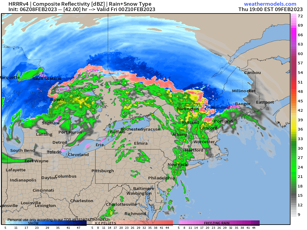
–Rain showers arrive by mid day, possibly as wintry mix in the northern Berkshires, northwest hilltowns and SVT/SWNH before changing to rain showers
–Showers quit Thursday night as a warm front moves through, with a very mild Friday on the way, breezy
–A beautiful, cooler weekend is on the way, with Saturday as the clear pick, as clouds may build in late on Sunday
–We have a coastal storm with plenty of precip pushing off of the Mid-Atlantic coast Sunday night, and as of now it stay south yet may graze us, but before we jump into the weather discussion/details below, let’s check a note from our local and delicious sponsor, #TandemBagelCo, with their newest location in West Springfield, MA.
~~~~~~~~~~~~~~~~~~~~~~
A NOTE FROM OUR SPONSOR:
Dave Hayes The Weather Nut is Sponsored by Members, Patrons & Tandem Bagel Company… No matter the weather, Tandem Bagel is always there for you at several valley locations to make your mornings brighter! With bagels baked fresh daily (including Gluten-Free options), house-whipped cream cheese, coffee, and tons of lunch options, Tandem is the perfect quick stop for lunch, breakfast, or a coffee and bagel to go. Find them in Easthampton, Northampton, Hadley, Florence, and West Springfield, or use their super-streamlined online ordering tool by visiting their website.
~~~~~~~~~~~~~~~~~~~~~~~~~~~~~~~~
***DHTWN DAILY WEATHER REPORT***
~~~~~~~~~~~~~~~~~~~~~~~~~~~~~~~~
NATIONAL WEATHER SERVICE ALERTS
–None but watch for black ice this morning.
DHTWN REMINDER
–The odds of being a human are 1 in 400,000 billion, so do or share something you love today, even in a small way (see Kurt Vonnegut quote at end of post)
DAILY CELESTIAL (STAR):
–OUR STAR ROSE AT: 6:55am this morning
–OUR STAR WILL SET AT: 5:13pm this evening
–TOTAL DAYLIGHT TIME: 10 hours and 18 minutes
NIGHTLY CELESTIAL (MOON):
–OUR MOON WILL RISE AT: 8:09pm this evening
–OUR MOON WILL SET AT: 8:51am tomorrow morning
–MOON RISE DIRECTION: East
–MOON SET DIRECTION: West
–MOON PHASE: Waxing Gibbous (93.3%)
~~~~~~~~~~~~~~~~~~~~~~~~~~~~~~~~
DAILY TERRESTRIAL (ZoneCast)
ZONE 1 (Northern Region)
Southern VT, Southwest NH, N. Taconics NY
–High Temps: Mid 30s to Low 40s
–Low Temps: Mid to Upper 20s
–Wind: Westerly winds gust up to 25mph at times
–Skies: Partly Sunny on average
–Precipitation: Early patchy fog/drizzle then dry
ZONE 2 (Central Region)
WMass, N. CMass, N. Litchfield County, C./S. Taconics NY
–High Temps: Upper 30s to Upper 40s
–Low Temps: Mid 20s to Low 30s
–Wind: Westerly winds gust up to 25mph at times
–Skies: Partly to Mostly Sunny
–Precipitation: Early patchy fog/drizzle then dry
ZONE 3 (Southern Region)
S. CMass, S. Litchfield County, NC.CT, & NE.CT
–High Temps: Mid to Upper 40s
–Low Temps: Mid 20s to Low 30s
–Wind: Westerly winds gust up to 25mph at times
–Skies: Mostly Sunny
–Precipitation: Early patchy fog/drizzle then dry
~~~~~~~~~~~~~~~~~~~~~~~~~~~~~~~~
MORNING DISCUSSION
Good morning everybody, there are icy areas for sure out there this morning, with some accidents reported down in CT already, so take it easy as you head out the door. We’ve had freezing fog overnight, and likely some freezing drizzle on top of the sleet and freezing rain showers we had… we even had some convective cells produce a few claps of thunder with small hail, and even graupel and snow up in SVT!
Quite a night for sure… moving on, we have fair weather moving into the region along with high pressure and milder temps reaching the upper 30s to mid/upper 40s today, so any ice will melt under the influence of developing sunshine. Westerly winds will kick up to 20-25mph in gusts at times.
For tonight, any wind should die down and with a mostly clear night early temps should drop into the 20s to low 30s with high and mid level clouds building in very late.
We cloud up on Thursday with yet another storm in this broken-record winter that will pass well northwest of us, putting us on the warm side of the storm, and produce mostly rain showers in our region Thursday afternoon and evening.
We may start as a little snow or ice in far northwest MA and southern VT around mid-day, but should go to rain there too.
The best dynamics with this storm (lift, etc.) appears to be tracking north of us, so we can expect an area of showers moving through vs. a rain storm.
Highs Thursday will reach the upper 30s to mid 40s with lows in the mid 30s as showers quit overnight, and temps then RISE.
This is because a warm front will move through the region with a cold front trailing a good distance behind it. This will allow temps to shoot up into the mid 40s to mid 50s Friday under partly sunny skies accompanied by gusty southwesterly winds which will reach speeds of 35mph as mild air floods the region for a day.
A cold front will move in by Friday night, and drop temps into the mid to upper 20s as more seasonable air moves back in for the weekend.
Speaking of the weekend, it looks lovely right now with plenty of sunshine, and highs in the mid to upper 30s on Saturday and then the upper 30s to low 40s on Sunday, with Saturday night lows in the low 20s.
The Sunday night into Monday period is likely going to remain dry, but a coastal storm pressing east off of the Mid-Atlantic region must be monitored in case it trends more northerly with time, which could graze CT, RI and southeast MA.
Otherwise, we can expect mild and fair weather early to middle of next week with some showers possible by Wednesday or Thursday.
At this point, we’re looking mild through the third week of February, as I believe I mentioned, and so any snow lovers are likely to be disappointed in the meantime. There are some signals for cold to return the last week of February, but it’s just a signal at this point, and far off in the distance of time.
Have a great day!
Let’s Stay Together (click for options).
Join my Free Weekly Nutletter (click to join).
Follow me on Twitter (click to follow).
AND REMEMBER…
“Hello babies. Welcome to Earth. It’s hot in the summer and cold in the winter. It’s round and wet and crowded. On the outside, babies, you’ve got a hundred years here. There’s only one rule that I know of, babies: Goddamn it, you’ve got to be kind.”
–Kurt Vonnegut