
WHAT YOU’LL GET WHEN YOU SCROLL
–Weekly Nutshell (Quick impact list)
–Sponsor Note (Tandem Bagel Co.)
–NWS Alerts (Advisories, Warnings, Watches)
–Celestial Data (Sun/Moon info)
–Morning Discussion (Longer-form explanation)
——————————-
DAVE’S WEEKLY WEATHER NUTSHELL
–We have all the precip types this morning, cold rain, freezing rain, sleet, and snow in far northern and northwest MA up into SVT/SWNH, mixed with ice at times
–Some areas could see over a foot in SVT and SWNH, maybe even west county in Franklin
–Showery mixed precip this morning transitions to steadier sleet then snow by late morning, lasting through mid to late afternoon
–May stay mixed or go from sleet to snow to mix in the southern Pioneer Valley from Hartford to Springfield, maybe as far north as Northampton/Hadley
–Everything quits by evening, 5-10″ Rt. 2 north, 2-5″ south of Rt. 2, some pockets of 10-15″ in SVT / SWNH / Western Franklin MA
–Some sub-2″ in CT River Valley floor from Springfield south
–Northwest winds gust to 25mph tonight and tomorrow with more outages possible (already 12000 in our region this morning)
–Nicer Tuesday with some yellow-white orb peeks
–Cloud up Wednesday, snow by afternoon with accumulation of 2-5″ into the night before mixing and changing to rain overnight
–Rainy and windy on Thursday
–Colder and calmer Friday through the weekend, but before we jump into the weather discussion/details below, let’s check a note from our local and delicious sponsor, #TandemBagelCo, with their newest location in West Springfield, MA.
——————–
A NOTE FROM OUR SPONSOR:
DHTWN Is Sponsored by Members, Patrons & Tandem Bagel Company: No matter the weather, Tandem Bagel is always there for you at several valley locations to make your mornings brighter! With bagels baked fresh daily (including Gluten-Free options), house-whipped cream cheese, coffee, and tons of lunch options, Tandem is the perfect quick stop for lunch, breakfast, or a coffee and bagel to go. Find them in Easthampton, Northampton, Hadley, Florence, and West Springfield, or use their super-streamlined online ordering tool by visiting their website.
——————————————-
***DHTWN DAILY WEATHER REPORT***
——————————————-
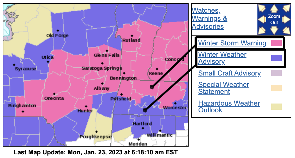
NATIONAL WEATHER SERVICE ALERTS
–Winter Storm Warnings are up for SVT, SWNH, Franklin County, northern half of Berkshire County, western Hampshire County, northern Worcester County
–Winter Weather Advisories are up for the rest of the non-warned areas in MA and most of northern CT except southern Litchfield
DHTWN REMINDER
–The odds of being a human are 1 in 400,000 billion… make it count, even in a small way (see Kurt Vonnegut quote at end of post)
DAILY CELESTIAL (STAR):
–OUR STAR ROSE AT: 7:11am this morning
–OUR STAR WILL SET AT: 4:53pm this evening
–TOTAL DAYLIGHT TIME: 9 hours and 42 minutes
NIGHTLY CELESTIAL (MOON):
–OUR MOON WILL SET AT: 7:15pm this evening
–OUR MOON WILL RISE AT: 9:18am tomorrow morning
–MOON SET DIRECTION: West-Southwest
–MOON RISE DIRECTION: East-Southeast
–MOON PHASE: Waxing Crescent (4.3%)
———————-
DAILY TERRESTRIAL (ZoneCast)
ZONE 1 (Northern Region)
Southern VT, Southwest NH, N. Taconics NY
–High Temps: Low to Mid 30s
–Low Temps: Low to Mid 20s
–Wind: Northwest winds gust 25-35mph by tonight into Tuesday
–Skies: Overcast
–Precipitation: Snow, heavy at times, 5-10″ in the lower elevations of this region, 10-15″ at higher elevation in spots, ends this evening
ZONE 2 (Central Region)
WMass, N. CMass, N. Litchfield County, C./S. Taconics NY
–High Temps: Mid 30s
–Low Temps: Mid to Upper 20s
–Wind: Northwest winds gust 20-35mph by tonight into Tuesday
–Skies: Overcast
–Precipitation: Rain, Ice or Snow early changing to all snow or snow/sleet mix. heavy at times later, 5-10″ in the lower northern parts of this region, 10-15″ possible in a few high elevation spots of western Franklin or even western Hampshire County, 2-5″ elsewhere, ends this evening
ZONE 3 (Southern Region)
S. CMass, S. Litchfield County, NC.CT, & NE.CT
–High Temps: Low to Mid 30s
–Low Temps: Mid to Upper 20s
–Wind: Northwest winds gust 20-30mph by tonight into Tuesday
–Skies: Overcast
–Precipitation: Rain or ice this morning changing to mix or snow depending on elevation, 1-4″ total expected, maybe just coatings in southern Litchfield or southern halves of northern CT, ends this evening
———————-
WHERE’S DAVE?
1. I’ve been reporting our weather daily here and at https://www.westernmassweather.com for a decade
2. Get my free weekly newsletter here: https://westernmassweather.com/homepage/dhtwn-nutletter-signup/
3. Actively visit this FB page via the app or web, as I may not always auto-kiss your screens
———————-
MORNING DISCUSSION
Good morning everybody, we’ve got temps out there in the upper 20s to mid 30s depending on where you are with all the precip types falling in various locations, including rain, freezing rain, sleet and snow (no graupel, though we had some last night early!).
After our changeover last night mainly south of the MA/VT-NH line (though some did not changeover and already have over half a foot of snow), we are cooling the atmosphere back down aloft, as our surface low track east toward Nantucket, staying south of New England.
This is going to pull not only colder air back into the region, but an upper trough to the west will do the same thing, and also push a well-developed deformation band of moderate to heavy precipitation back through the greater WMass region as the morning and afternoon wears on.
We already snowing in much of the Berkshires into the western hilltowns, and as more showery / lull-y type precip gets displaced east, and replaced with that steadier band to our west, more and more in WMass and northern CT we will transition back to sleet and then snow between mid to late morning.
By late morning to around noon we should all be snowing, or with a snow/sleet mix as colder air moves back in along with that back-edge band of precipitation.
Additional accumulating snow is expected today just about everywhere, though after we turn to snow, it’s possible that by early afternoon some rain and/or sleet mixes back in to the Hartford to Springfield corridor and adjacent flat-land locations, POSSIBLY as far north as Northampton, but I’m leaning towards Northampton/Hadley/Amherst and points north remaining all snow after the change.
Slippery roads are expected for some this afternoon as snow becomes moderate to perhaps heavy at times, and there is a low chance for an upside bust in terms of snow if a shortwave can combine with this precip shield over easternmost Hampden and Hampshire Counties into CMass where heavy snow could fall, but I will be monitoring that.
TOTALS
Generally speaking, it is 2-5″ south of Rt. 2 corridor in all of WMass, CMass and northern CT (that includes accumulation from last night, if any), with some sub-2″ amounts in the southern CT River Valley of MA and CT.
5-10″ along and north of Rt. 2, including central and northern Berkshires, the northwest hilltowns, much of Franklin County (some sub-5″ amounts in southern parts of Franklin), northern Worcester County and SVT and SWNH.
10-15″ is possible for some localized spots in SVT and SWNH, and we may see over 10″ western Franklin County as well.
Lows tonight dip into the mid to upper 20s with a few flurries and watch for black ice, as roads will refreeze everywhere.
For Tuesday, partly sunny to mostly cloudy with highs in the 30s with brief high pressure nosing in. Lows will drop to near 20º.
For Wednesday, our last storm in this trifecta storm train pushes its warm front into our region by afternoon.
It will be colder Wednesday with highs in the low 30s, and so even though our storm is going to track well west of us and shove a bunch of rain in here by late Wednesday night into Thursday, we will see a front-end thump of accumulating snow most likely with about 2-5″ during the afternoon and evening before any mix or rain later at night, so the evening commute could be hazardous.
We could also see winds picking up and gusting to 40mph by Thursday with rain, and then after the cold front comes in, so some isolated wind damage is possible.
Highs on Thursday will reach the upper 30s to low 40s with a crash in temps behind the front Thursday night down into the teens with strong wind gusts out of the northwest.
Friday is the pick of the week for sunshine, but it will be cold only in the 20s for highs and teens for lows, with more partial sunshine and highs in the 30s over the weekend.
Have a great day, and be alert to changing road conditions and precip types today, as we’re getting colder with time, and going back to sleet and snow from northwest to southeast, with that late morning to later afternoon period being a time when snow could become steady and/or heavy, and impact travel.
I will update by early afternoon…
Join my Free Weekly Nutletter.
AND REMEMBER…
“Hello babies. Welcome to Earth. It’s hot in the summer and cold in the winter. It’s round and wet and crowded. On the outside, babies, you’ve got a hundred years here. There’s only one rule that I know of, babies: Goddamn it, you’ve got to be kind.”
–Kurt Vonnegut