
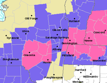
Magenta is Winter Storm Warnings, blue is Winter Weather Advisories
–We start cloudy, and despite a few breaks of sun possible, we’re going to remain mostly cloudy today
–Temps now in the 20s to low 30s rise to mid/upper 30s
–Rain and snow arrives around dinner time, as early as 5pm NW.CT/S.Berkshires to 7-8pm northern Worcester County
–After rain/snow mix at the start, we should snow north of the Pike for a few hours tonight, then rain/mix pushes north to the MA/VT-NH state line around midnight
–Far northern Berkshires, western Franklin County and SVT likely stays all snow or snow/sleet mix late
–During Monday morning we change back to snow by late morning or so, and see periods of snow during the afternoon, ending at night
–2-5″ across much of the area, but 5-10″ along and north of Rt. 2, with up to a foot possible in SVT in spots, a few areas under 2″ in northern CT up to either Springfield or Great Barrington in those valleys
–Tuesday blustery, cold, a few snow showers Berkshires
–By Wednesday early afternoon, accumulating snow arrives into the evening, then changes to rain, but up to half foot possible with front-end thump
–Storm quits on Thursday after turning to rain, then colder and blustery late week into the weekend with fair weather and another storm possible Monday, but before we dive into all of the weather details below, let’s check a note from our new local weekend sponsor, #CranberryHillHealingArts located in Amherst, MA.
——————–
A NOTE FROM OUR WEEKEND SPONSOR:
DHTWN is sponsored by members, patrons, and Cranberry Hill Healing Arts. The turning of the seasons can be challenging, and Carolyn Walker of Cranberry Hill Healing Arts in Amherst is there for you. When you are searching for ways to be at peace, seek relaxation, and feel more energetic, let Reiki & Sound Healing guide you on your journey to wholeness. Through energy work and the gentle vibrations of singing bowls, chimes, and chanting, Carolyn crafts a safe and calming space to experience renewal. Learn more and/or book your session today by visiting her website.
——————————————-
***DHTWN DAILY WEATHER REPORT***
——————————————-
Good morning everybody, we’re waking up to cloudy skies today with low clouds locked in, and on top of that mid to high level clouds will be streaming in from our approaching storm system.
While a few breaks of sun are possible, it’s mostly cloudy today with highs in the mid to upper 30s after a chilly start as low as the upper teens to low 20s in far northwest MA up into SVT, but 20s to low 30s elsewhere.
We have a positively-tilted trough (i.e. oriented from SW to NE) tracking east into the Great Lakes, and in response surface low pressure is developing in the southeast U.S. and will emerge off of the Virginia coastline and track northeast from the DelMarVa Peninsula to near Nantucket late tonight.
This is a bit more southerly of a track than originally though with this storm, and if we had a cold high pressure center to our north, this would be a no-brainer for all snow across the entire region with a storm track like that!
However, so far this winter (aside from that December Arctic outbreak) the truly bone-chilling temps not that far north of us in Canada and the outer Arctic have been bottled north due t prevailing flow in January.
Having said all that, milder air will be allowed to surge north at the surface and aloft tonight, which will allow us to see rain and snow to move into the greater WMass region by around dinner time and overspread the region by 8pm or so.
We’ll have rain or rain/snow mix in the southern half of MA and northern CT, with snow in the high terrain of the central and northern Berkshires, the northwestern hilltowns of Hampshire and Franklin County and southern VT.
In the valley and CMass down to about the level of the MassPike, we should flip to snow for a couple of hours after the initial precip onset, but then the milder air aloft pushes north by midnight to the MA/VT-NH border and flips many of us to rain rain/snow mix, while all snow or a snow/sleet mix continues in the northern Berkshires, western Franklin County, southern VT and much of southwest NH.
Lows will eventually descend into the low to mid 30s overnight.
By Monday morning our storm system will have tracked northeast from the DelMarVa to south of Cape Cod and will be strengthening and pulling away to the east.
Most of us along and east of the I-91 corridor and south of Rt. 2 should be raining or seeing a mix of rain/sleet/snow at dawn.
As the storm tracks east it will drag colder air in at all levels from northwest to southeast and flip all of us back to snow by mid to late morning, so this has implications for the Monday morning commute in the western hilltowns, Berkshires, and areas north of Rt. 2 in MA, VT and NH.
Then by mid-day through the afternoon it looks like as the storm strengthens will cause a wraparound snow band to form, which is what the snow totals are contingent upon.
If that formation is weaker, totals will be at lower end of range.
Snow ends Monday night and west winds pick up with blustery conditions and gusts 25-35mph overnight into Tuesday with lows in the mid 20s and highs Tuesday in the mid to upper 30s.
SNOW AMOUNTS
–5-10″ for the northern Berkshires, western Franklin and western Hampshire Counties, northern MA along and north of Route 2 into SVT and SWNH, including much of Franklin County, except perhaps southern towns that border Hampshire
–2-5″ south of Route 2 in much of WMass, the Pioneer Valley, southern Berkshires, southern half of CMass, and the northern halves of Tolland, Windham and Litchfield Counties
–C-2″ for southern halves of the northern CT counties up into northern Hartford County (except its NW nook near the Bark Res, which is 2-5″)…Springfield metro could see under 2″ as well, but leaving it 2-5″ for now
WEDNESDAY/THURSDAY STORM: FRONT END THUMP
Tuesday night continues cold and blustery behind our Monday storm with lows either side of 20º and then winds slacken Wednesday as the next storm system lines up to run through New England.
This one definitely looks like an inside runner at the moment, but much colder air will be in place already.
This will setup an ideal cold overrunning surface for precip to rise up and provide a burst of front-end thump snowfall starting around early to mid afternoon and lasting into the evening with up to half a foot possible before we ALL change to rain overnight into Thursday.
Cold and mostly cloudy conditions will prevail by Friday and Saturday, and then we have to watch next Sunday or Monday for another storm.
A trend is starting to be signaled that we are gradually cooling down into February as it approaches, and if the storm train continues in this active pattern, we may be talking about more snowy systems, but that’s putting the cart before the horse.
Let’s get through and focus on this one and the mid-week system as that will have plenty of impacts for many across the region, even despite the mix/rain aspects to these storms.
Have a great day, and I will post another update by early afternoon and again in the evening as the storm is setting into the region, thanks for reading!
Join my Free Weekly Nutletter.
You can also follow me on Twitter.
AND REMEMBER…
“Hello babies. Welcome to Earth. It’s hot in the summer and cold in the winter. It’s round and wet and crowded. On the outside, babies, you’ve got a hundred years here. There’s only one rule that I know of, babies: Goddamn it, you’ve got to be kind.”
–Kurt Vonnegut