
WEEKLY WEATHER NUTSHELL
–Black ice slippery patches this morning with cold sub-freezing temps and overnight snow dustings
–Developing partial sunshine today, highs low to mid 30s
–Cold tonight, lows in the mid/upper teens, partly cloudy
–Clouds build tomorrow, snow and rain arrives after sunset by 6-8pm
–Accumulating snow in northern Berkshires, northwest hilltowns (western Hampshire/Franklin) and southern VT into southwest NH, and northernmost Worcester County
–Rain/snow mix or rain in the Pioneer Valley from Bernardston/Greenfield south down into northern CT and east into CMass
–Snow and rain quits by Monday morning, windy, colder
–Fair weather Tuesday, then another snow to rain storm Wednesday into Thursday, with potential for accumulating snow everywhere before the changeover, but before we dive into all of the weather details below, let’s check a note from our new local weekend sponsor, #CranberryHillHealingArts located in Amherst, MA.
——————–
A NOTE FROM OUR WEEKEND SPONSOR:
DHTWN is sponsored by members, patrons, and Cranberry Hill Healing Arts. The turning of the seasons can be challenging, and Carolyn Walker of Cranberry Hill Healing Arts in Amherst is there for you. When you are searching for ways to be at peace, seek relaxation, and feel more energetic, let Reiki & Sound Healing guide you on your journey to wholeness. Through energy work and the gentle vibrations of singing bowls, chimes, and chanting, Carolyn crafts a safe and calming space to experience renewal. Learn more and/or book your session today by visiting her website.
——————————————-
***DHTWN DAILY WEATHER REPORT***
——————————————-
Good morning everybody, we had some snow showers pass from north to south overnight which coated over some areas that didn’t get any snow accumulation yesterday.
With that plus patches of black ice, watch for slick spots out there this morning as many temps start off in the 20s.
For today, higher pressure is pressing in from the west (funny how pressure presses!) which will dry things out, thin cloud decks, and allow for partial sunshine to develop today with highs in the low to mid 30s with a light northwest breeze.
For tonight, partly cloudy skies will continue, and with light wind lows will crater down into the mid to upper teens for a cold night ahead.
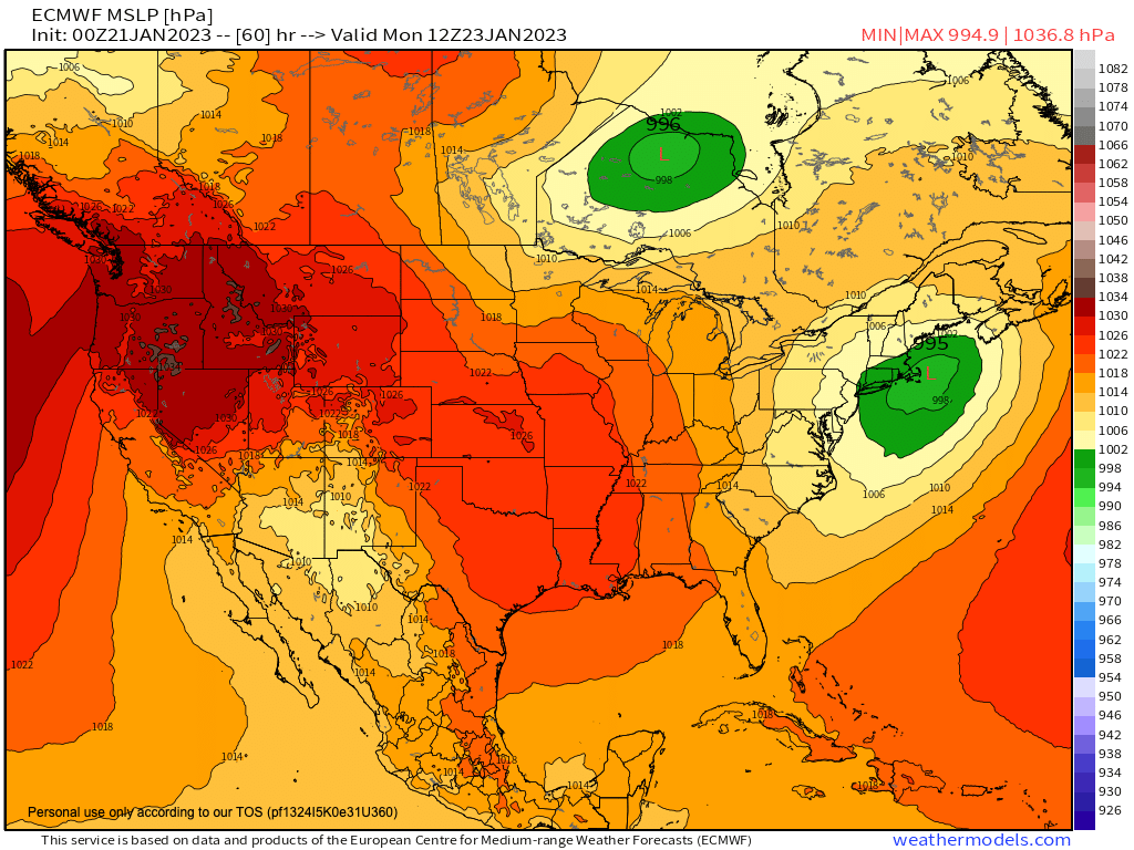
On Sunday, clouds will thicken as an upper trough pushes into the Great Lakes region with a surface low developing off of the Carolina coastline and tracking northeast towards Cape Cod as it strengthens and drops to a 995mb-ish low center.
Normally, this would mean all snow or mostly snow for much of our region.
However, there is no cold source region to our north, and no high pressure expected to be to our north. In fact, there is another area of low pressure that will be lifting east into eastern Ontario and western Quebec, and with counterclockwise flow this encourages a draw of more southerly air based on that low’s position relative to our coastal low.
You want a big old cold Arctic high in that position with clockwise flow directing cold air SOUTH into New England to get the classic coastal southern New England snowstorm to materialize.
Given our double low center setup, milder air will push north of the low center and likely cause rain to begin from the start from Springfield points east and south, but maybe farther north than that.
Given that this is a night time arrival, and depending on consistency of the precip shield, we may get snow down into the Greenfield to Northampton/Holyoke stretch of the northern and central valley for a time with light accumulations before going to rain, I will have to update on this as we get closer.
But essentially this is another far northern and far northwestern MA into SVT and SWNH moderate snowfall potential with 2-6″ in those areas, and some areas perhaps getting up to 8″ along the spine of the southern Green Mountains with a coating to 2″ south and east of there.
Highs on Sunday will reach the mid to upper 30s and lows will drop to near freezing, and snow and rain will quit by Monday noon, and we may see a flip back to snow for a period on Monday that has the low chance of laying down new coatings in most parts of our region by Monday noon, but I will update on that we get closer.
Behind this system, strong northwest winds should gust up to 30mph Monday afternoon and night which will make conditions blustery with lows down into the low 20s.
Tuesday starts off breezy, but wind should slacken with highs in the mid to upper 30s under mostly sunny skies, and lows in the upper teens to low 20s.
The mid-week storm system will cause clouds to build Wednesday morning, with snow arriving most parts of our region Wednesday afternoon, with seasonable highs in the low to mid 30s.
At some point, depending on storm track, we’re likely to again see a similar set up of snow continuing in far northwest MA and SVT/SWNH, with snow and rain elsewhere.
This storm will last through Wednesday night and quit Thursday morning.
Far northwest MA, including the northwest hilltowns of western Hampshire and Franklin Counties up into SVT/SWNH should be looking quite wintry by the end of this upcoming week with potentially over a foot of snow on the ground in some spots.
The rest of us in the valley, southern CMass and northern CT, likely not so much, but I will keep you updated on all of it, thanks for reading, and have a great day!
Join my Free Weekly Nutletter.
You can also follow me on Twitter.
AND REMEMBER…
“Hello babies. Welcome to Earth. It’s hot in the summer and cold in the winter. It’s round and wet and crowded. On the outside, babies, you’ve got a hundred years here. There’s only one rule that I know of, babies: Goddamn it, you’ve got to be kind.”
–Kurt Vonnegut