
WHAT YOU’LL GET WHEN YOU SCROLL
–Weekly Nutshell (Quick impact list)
–Sponsor Note (Tandem Bagel Co.)
–NWS Alerts (Advisories, Warnings, Watches)
–Celestial Data (Sun/Moon info)
–Terrestrial Data (Localized Summary Forecasts)
–Morning Discussion (Longer-form explanation)
——————————-
DAVE’S WEEKLY WEATHER NUTSHELL
–Possible nice sunrise for some this morning (post pics!), then clouds fill in
–Snow, sleet and rain arrive from noon to 4pm SW to NE
–Valley will see a mix of precip, with mostly rain and some sleet from Springfield south to Hartford, with snow, sleet and rain north of there (more wintry at elevation, less so in valleys)
–Berkshires, western hills, northernmost MA, SVT and SWNH may go to a thump of snow by mid to late afternoon, or snow and sleet mix, could be heavy
–Snow goes to freezing rain or sleet in the western hilltowns and Berkshires tonight for a time, with an icy mix into SVT and over into much of Franklin and Hampshire County
–However, northeast Franklin County into southwest NH and northern Worcester County may thump with heavy snow or heavy snow/sleet mix after about 8pm with most accumulation post-sunset until just after midnight
–We lull after midnight with freezing drizzle, slippery conditions, especially in the high terrain and north of Rt. 2
–More periods of light to moderate snow, scattered, with the upper level system Friday into Friday evening, additional accumulations
–More tranquil Saturday, Sunday and Tuesday
–Stormy Sunday night into Monday with snow and rain, and also stormy with snow and rain Wednesday into Thursday morning, but before we jump into the weather discussion/details below, let’s check a note from our local and delicious sponsor, #TandemBagelCo, with their newest location in West Springfield, MA.
——————–
A NOTE FROM OUR SPONSOR:
DHTWN Is Sponsored by Members, Patrons & Tandem Bagel Company: No matter the weather, Tandem Bagel is always there for you at several valley locations to make your mornings brighter! With bagels baked fresh daily (including Gluten-Free options), house-whipped cream cheese, coffee, and tons of lunch options, Tandem is the perfect quick stop for lunch, breakfast, or a coffee and bagel to go. Find them in Easthampton, Northampton, Hadley, Florence, and West Springfield, or use their super-streamlined online ordering tool by visiting their website.
——————————————-
***DHTWN DAILY WEATHER REPORT***
——————————————-
NATIONAL WEATHER SERVICE ALERTS
–Winter Weather Advisories are up for SVT, SWNH, WMass, CMass, and Litchfield and Hartford Counties in CT
DHTWN REMINDER
–The odds of being a human are 1 in 400,000 billion… make it count, even in a small way (see Kurt Vonnegut quote at end of post)
DAILY CELESTIAL (STAR):
–OUR STAR ROSE AT: 7:14am this morning
–OUR STAR WILL SET AT: 4:48pm this evening
–TOTAL DAYLIGHT TIME: 9 hours and 34 minutes
NIGHTLY CELESTIAL (MOON):
–OUR MOON WILL SET AT: 2:01pm this afternoon
–OUR MOON WILL RISE AT: 6:30am tomorrow morning
–MOON SET DIRECTION: Southwest
–MOON RISE DIRECTION: Southeast
–MOON PHASE: Waning Crescent (8.5%)
———————-
DAILY TERRESTRIAL (ZoneCast)
ZONE 1 (Northern Region)
Southern VT, Southwest NH, N. Taconics NY
–High Temps: Mid to Upper 30s
–Low Temps: Upper 20s to Low 30s
–Wind: Light or Calm
–Skies: Becoming Cloudy
–Precipitation: Mixed, Freezing Drizzle overnight, See Discussion
ZONE 2 (Central Region)
WMass, N. CMass, N. Litchfield County, C./S. Taconics NY
–High Temps: Mid to Upper 30s
–Low Temps: Low to Mid 30s
–Wind: Light or Calm
–Skies: Becoming Cloudy
–Precipitation: Mix or Rain, Freezing Drizzle overnight, See Discussion
ZONE 3 (Southern Region)
S. CMass, S. Litchfield County, NC.CT, & NE.CT
–High Temps: Mid to Upper 30s
–Low Temps: Low to Mid 30s
–Wind: Light or Calm
–Skies: Becoming Cloudy
–Precipitation: Mostly rain with some icing in the northwest hills of CT, sleet possible in high terrain of southern CMass, Freezing drizzle overnight
———————-
WHERE’S DAVE?
1. I’ve been reporting our weather daily here and at https://www.westernmassweather.com for a decade
2. Get my free weekly newsletter here: https://westernmassweather.com/homepage/dhtwn-nutletter-signup/
3. Actively visit this FB page via the app or web, as I may not always auto-kiss your screens
———————-
MORNING DISCUSSION
Good morning everybody, we have a very complex storm system moving into the region today and tonight which will bring all the precip types, including snow, sleet, freezing rain, and plain rain, and even freezing drizzle after midnight, before it all changes to periods of light to perhaps moderate snow on Friday as the upper level system moves through New England.
For this morning, some of us may catch a few breaks allowing for a colorful sunrise, so if you get to witness such a spectacle please color the comments below with your sunrise-y camera snaps for all to see!
Clouds will thicken rapidly this morning as a large area of precipitation extends and lifts east-northeast through PA and NY and towards New England.
Highs will reach the mid to perhaps upper 30s today before falling this evening into the low 30s for lows overnight. As you can see, a change in temperature of 1º will make the difference between heavy snow or heavy sleet, or from freezing rain to plain rain, so there’s a strong bust potential with this system in terms of snow/sleet accumulations.
If the temperatures warm by one or two degrees more than thought, we could all see the lowest ranges of the snow amounts I posted below.
TIMING
Precipitation will reach far northwest CT and the southern Berkshires/Taconics by about noon, and then track east-northeast into the rest of the greater WMass region through early afternoon, reaching northern CMass and southwest NH by 3pm or 4pm.
MIX MESS
We’ll start off with rain or a snow/sleet/rain mix across the region, and as precip becomes steadier, areas like the eastern Berkshires, western hilltowns up into southern VT should go over to snow for a time, or snow/sleet mix into the late afternoon and early evening before sleet or even freezing rain makes it up into these areas before midnight.
The same type of process should happen (mix to snow) north of the Rt. 2 corridor in Franklin County into northern CMass and southwest NH where the heaviest accumulations from this system should fall, though this potential flip to heavy snow would occur later this evening there, I believe.
Mixed precip or rain in the CT River Valley of MA and CT is expected this afternoon into the early evening (more mix north, more rain south). It will snow at times in the northern valley and some light accumulations are possible from Northampton north through tonight.
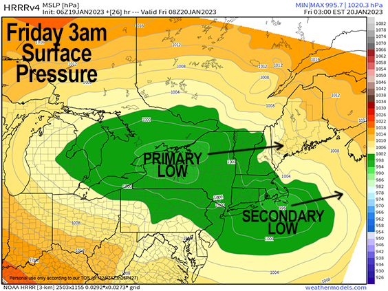
As I mentioned previously regarding NE Franklin, southwest NH and northern CMass, by about 8-10pm (and thanks to our secondary low pressure system tracking south of New England and headed east), colder air should be working into the region with changes over to snow where there was icing along and north of the Route 2 corridor, with some high terrain areas south of Rt. 2 also changing over to snow with mixes elsewhere, before we lull out after midnight and go to freezing drizzle – this is when the snow most accumulates in this part of our region.
Generally speaking, slippery conditions are expected tonight in most areas north of the Pike from at least the freezing drizzle if not earlier mixed ice and snow, or snow accumulations in the western high terrain and northern MA up into SVT/SWNH.
By Friday morning our upper level system starts to move into the region which will cool the atmosphere aloft with the colder air at the surface working in behind the departing secondary low.
This will promote periods of snow showers throughout the day with additional light accumulations to possible additional moderate accumulations in SVT down into the NE Berkshires / NW Franklin County area.
BENNINGTON AREA BUST
This part of southern VT will see less snow/sleet accumulation than areas east due to its low elevation and likely warmer temps so I expect less accums here and more mix or even rain for a time.
AMOUNTS
All in all by Friday evening, we can expect a coating to 2″ from about the MA/CT state line up to near the Rt. 2 corridor, with 2-6″ along and north of Rt 2 in northern MA up into SVT and SWNH, with areas of 5-10″ in parts of southwest NH, northern Worcester County and southern VT.
The weekend looks tranquil with highs in the 30s, partly sunny Saturday and mostly cloudy Sunday with more rain and snow Sunday night into Monday, with a tranquil period from Monday night into Wednesday morning followed by another rain and snow storm Wednesday afternoon into Thursday morning, all of which will be building the snow pack for northern New England skiing, so that’s great news for skiers.
Have a great day and I will be updating around mid-day and again this evening as our complex storm systems sets in, thanks for reading!
Join my Free Weekly Nutletter.
AND REMEMBER…
“Hello babies. Welcome to Earth. It’s hot in the summer and cold in the winter. It’s round and wet and crowded. On the outside, babies, you’ve got a hundred years here. There’s only one rule that I know of, babies: Goddamn it, you’ve got to be kind.”
–Kurt Vonnegut