
WHAT YOU’LL GET WHEN YOU SCROLL
–Weekly Nutshell (Quick impact list)
–Sponsor Note (Tandem Bagel Co.)
–NWS Alerts (Advisories, Warnings, Watches)
–Celestial Data (Sun/Moon info)
–Terrestrial Data (Localized Summary Forecasts)
–Morning Discussion (Longer-form explanation)
——————————-
DAVE’S WEEKLY WEATHER NUTSHELL
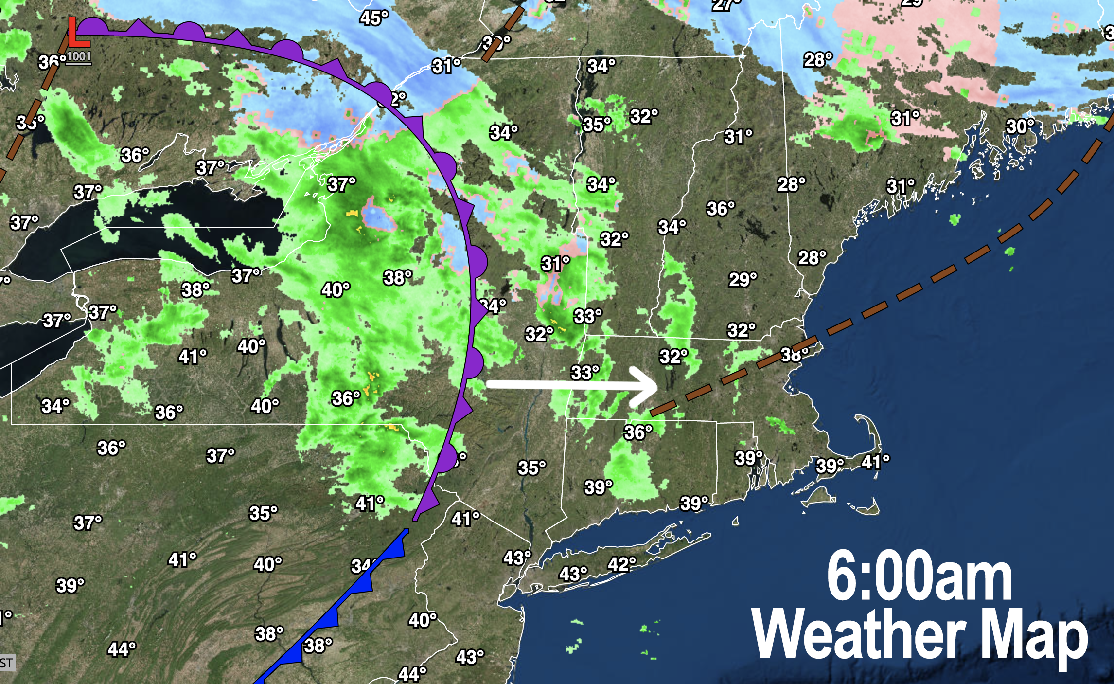
–Isolated freezing rain and rain showers with some localized icy spots this morning
–These change to snow and rain showers as the front moves through, snow western high terrain and rain valley and points east
–Any precip abates except some upslope snow showers linger in the west-facing Berkshires and southern Green Mountains
–West winds gust to 25mph behind the front this afternoon
–Winds calm tonight, tranquil through Thursday morning
–Clouds build Thursday and rain, sleet and snow arrive by early afternoon (rain/sleet southern MA into northern CT, snow/sleet northern MA into VT/NH)
–Mixed precipitation continues until around midnight and we enter a lull
–Snow accumulations of 2-5″ expected along and north of Rt. 2 in northern MA up into SVT / SWNH, less south thru early Friday morning
–Colder air works in with periods of light snow by Friday morning through the day, additional light accumulations possible
–Cloudy cold and calm Saturday with more rain and snow Sunday night into Monday
–Tranquil Tuesday leads to another winter storm Wednesday into Thursday, but before we jump into the weather discussion/details below, let’s check a note from our local and delicious sponsor, #TandemBagelCo, with their newest location in West Springfield, MA.
——————–
A NOTE FROM OUR SPONSOR:
DHTWN Is Sponsored by Members, Patrons & Tandem Bagel Company: No matter the weather, Tandem Bagel is always there for you at several valley locations to make your mornings brighter! With bagels baked fresh daily (including Gluten-Free options), house-whipped cream cheese, coffee, and tons of lunch options, Tandem is the perfect quick stop for lunch, breakfast, or a coffee and bagel to go. Find them in Easthampton, Northampton, Hadley, Florence, and West Springfield, or use their super-streamlined online ordering tool by visiting their website.
——————————————-
***DHTWN DAILY WEATHER REPORT***
——————————————-
NATIONAL WEATHER SERVICE ALERTS
–Winter Weather Advisories for southern VT have expired but isolated icy surfaces possible in the Berkshires, western hills, Franklin County and SVT/SWNH this morning
DHTWN REMINDER
–The odds of being a human are 1 in 400,000 billion… make it count, even in a small way (see Kurt Vonnegut quote at end of post)
DAILY CELESTIAL (STAR):
–OUR STAR ROSE AT: 7:14am this morning
–OUR STAR WILL SET AT: 4:47pm this evening
–TOTAL DAYLIGHT TIME: 9 hours and 33 minutes
NIGHTLY CELESTIAL (MOON):
–OUR MOON WILL SET AT: 1:07pm this afternoon
–OUR MOON WILL RISE AT: 5:21am tomorrow morning
–MOON SET DIRECTION: Southwest
–MOON RISE DIRECTION: Southeast
–MOON PHASE: Waning Crescent (16.2%)
———————-
DAILY TERRESTRIAL (ZoneCast)
ZONE 1 (Northern Region)
Southern VT, Southwest NH, N. Taconics NY
–High Temps: Mid 30s to Low 40s
–Low Temps: Mid to Upper 20s
–Wind: Light wind early, west winds gusting to 25mph later today
–Skies: Mostly cloudy, a few sunny breaks possible this afternoon
–Precipitation: Scattered rain and freezing rain showers turn to scattered upslope snow showers, may see some coatings in SVT
ZONE 2 (Central Region)
WMass, N. CMass, N. Litchfield County, C./S. Taconics NY
–High Temps: Upper 30s to Mid 40s, possibly upper 40s
–Low Temps: Mid 20s to Low 30s
–Wind: Light wind early, west winds gusting to 25mph later today
–Skies: Mostly cloudy, a few sunny breaks possible this afternoon
–Precipitation: Scattered rain and freezing rain showers turn to scattered upslope snow showers in the Berkshires/western hills, isolated coatings possible, otherwise drying east of there
ZONE 3 (Southern Region)
S. CMass, S. Litchfield County, NC.CT, & NE.CT
–High Temps: Mid to Upper 40s
–Low Temps: Upper 20s to Low 30s
–Wind: Light wind early, west winds gusting to 25mph later today
–Skies: Mostly cloudy, a few sunny breaks possible this afternoon
–Precipitation: Scattered rain showers early then drying
———————-
WHERE’S DAVE?
1. I’ve been reporting our weather daily here and at https://www.westernmassweather.com for a decade
2. Get my free weekly newsletter here: https://westernmassweather.com/homepage/dhtwn-nutletter-signup/
3. Actively visit this FB page via the app or web, as I may not always auto-kiss your screens
———————-
MORNING DISCUSSION
Good morning everybody, I hope you slept well and are packed with vim and vigor and ready to express that out into the world in equal measure today.
And if not? Well, if you’re stumbling and bumbling like this writer, may you find a slow and steady ramp-up into a day that I hope expands and supports a day of goodness for you and those you reach.
As for our weather, we have some atmospheric inclemency underway across the region this morning – nothing earth-shaking, but some icy spots are possible with scattered showers of rain and freezing rain, which are in the process of converting to snow showers where temps are supportive.
This is due to our occluded frontal boundary pressing eastward into the region, and cooling temps aloft enough to get some upslope snow showers going as the morning wears on in parts of the Berkshires, SVT and the Taconics, possibly bleeding into the western hilltowns.
Highs today under mostly cloudy skies will reach the mid to upper 30s in SVT on up and well into the 40s in WMass, CMass and northern CT, with west winds gusting up to 25mph behind the front as it tracks east.
We can’t rule out an isolated coating under any persistent upslope snow showers in SVT, either, nor a few sunny breaks late.
Winds tamp down tonight, and the upslope machine turns off with high pressure building into the region, with lows dropping into the 20s and low 30s overnight.
For Thursday, clouds increase quickly as another storm tracks northeast toward the eastern Great Lakes with a likely secondary low developing somewhere off of the Mid-Atlantic coastline.
It will be colder tomorrow, with highs in the mid to upper 30s, which will make nailing down precipitation type and locations very tricky.
We do have some cold high pressure to the north, and we will have a slug of heavier precipitation running into the region, and arriving by early afternoon, lasting through midnight into the early pre-dawn hours of Friday morning before we get a lull.
At this point, it appears that along and north of the Rt. 2 corridor is the best chance for mostly snow with sleet, freezing rain and rain south of Rt. 2 in WMass and CMass, mixed with snow at times. A mix to rain from about Northampton/Amherst south and east seems most likely at this point, but these marginal-temperature storms are difficult children to say the least.
As milder air works in with this system, the Bennington VT area down into North Adams may also turn to mix or rain for a time.
The bottom line is that it’s going to be stormy Thursday afternoon and night, and more wintry the further north you travel in MA and certainly in SVT / SWNH where 2-5″ or 3-6″ could fall by Friday morning, with less to the south.
Once we get to Friday morning, the upper level system may hook up with the secondary low tracking south of New England and bring colder air into the region which could enhance the precipitation as we all changeover to periods of light to perhaps moderate snow during the day on Friday, especially for areas north of the Pike, with less precip south of there.
Additional light accumulations are possible, and at this stage by Friday evening, I would say we can expect 3-7″ along and north of Rt. 2, 1-4″ between the Pike and Route 2, and a coating to 2″ south of the Pike, with some areas in northern CT getting nothing but rain or some “air snow”, or grassy dustings.
I would not be surprised to see some 7″+ amounts in the southern Greens if colder air “wins” with this storm.
Saturday looks dry and calm, but mostly cloudy with highs in the low to mid 30s and lows in the 20s, and Sunday looks mostly cloudy with increasing clouds by afternoon, with highs in the mid to upper 30s.
Another storm system runs at us for Sunday night into Monday with more snow and rain, but uncertainty remains with storm track and hence snow/rain lines, but accumulating snow is definitely possible for some of us, especially northwest MA into SVT/SWNH.
After that, ANOTHER storm could bring more wintry weather to the region as our pattern is becoming active and is starting to cool down as we end the month of January, so please stay tuned for updates on all of the storm activity coming our way to the greater WMass region, and have a great day!
Join my Free Weekly Nutletter.
AND REMEMBER…
“Hello babies. Welcome to Earth. It’s hot in the summer and cold in the winter. It’s round and wet and crowded. On the outside, babies, you’ve got a hundred years here. There’s only one rule that I know of, babies: Goddamn it, you’ve got to be kind.”
–Kurt Vonnegut