
WHAT YOU’LL GET WHEN YOU SCROLL
–Weekly Nutshell (Quick impact list)
–Sponsor Note (Tandem Bagel Co.)
–NWS Alerts (Advisories, Warnings, Watches)
–Celestial Data (Sun/Moon info)
–Terrestrial Data (Regional Summary Forecasts)
–Morning Discussion (Longer-form explanation)
——————————-
DAVE’S WEEKLY WEATHER NUTSHELL
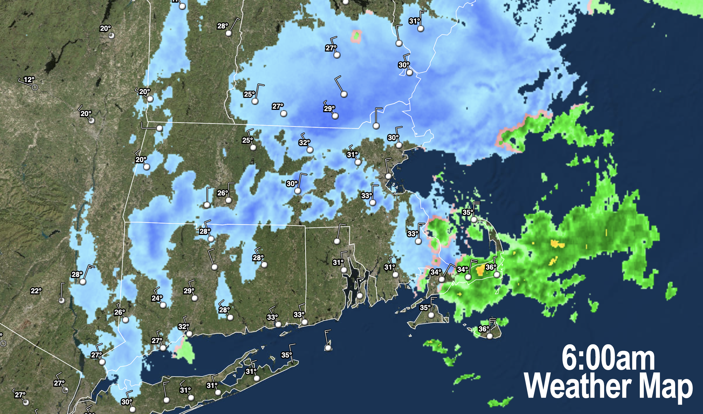
–Our ocean storm belched a bunch of snow onto the WMass region overnight with a coating up to 4″ reported of light fluff
–Take it easy on roads this morning if you are traveling
–Another band of snow and sleet is working southwest into northern Worcester County
–This band should graze eastern Franklin, Hampshire and Hampden Counties with an additional coating to an inch or so through 8am
–Going forward, scattered snow showers this morning give way to mostly cloudy skies with afternoon breaks of sun possible well west
–A sunny Tuesday start leads to rain showers at the end, which may mix with snow in the high terrain tomorrow night
–Clearing Wednesday makes way for more snow and rain Thursday later afternoon and night into Friday morning
–Temps are mild by middle of this week, and will cool off next weekend, with a winter storm possible Sunday night into Monday, but before we jump into the weather discussion/details below, let’s check a note from our local and delicious sponsor, #TandemBagelCo, with their newest location in West Springfield, MA.
——————–
A NOTE FROM OUR SPONSOR:
DHTWN Is Sponsored by Members, Patrons & Tandem Bagel Company: No matter the weather, Tandem Bagel is always there for you at several valley locations to make your mornings brighter! With bagels baked fresh daily (including Gluten-Free options), house-whipped cream cheese, coffee, and tons of lunch options, Tandem is the perfect quick stop for lunch, breakfast, or a coffee and bagel to go. Find them in Easthampton, Northampton, Hadley, Florence, and West Springfield, or use their super-streamlined online ordering tool by visiting their website.
——————————————-
***DHTWN DAILY WEATHER REPORT***
——————————————-
NATIONAL WEATHER SERVICE ALERTS
–None but roads are very slippery this morning, especially in Franklin County with overnight snow, and new snow moving into CMass and southeastern parts of WMass down into NE.CT
DHTWN REMINDER
–The odds of being a human are 1 in 400,000 billion… make it count, even in a small way (see Kurt Vonnegut quote at end of post)
DAILY CELESTIAL (STAR):
–OUR STAR ROSE AT: 7:15am this morning
–OUR STAR WILL SET AT: 4:44pm this evening
–TOTAL DAYLIGHT TIME: 9 hours and 29 minutes
NIGHTLY CELESTIAL (MOON):
–OUR MOON WILL SET AT: 11:54am this morning
–OUR MOON WILL RISE AT: 2:49am tomorrow morning
–MOON SET DIRECTION: West-Southwest
–MOON RISE DIRECTION: East-Southeast
–MOON PHASE: Waning Crescent (35.7%)
———————-
DAILY TERRESTRIAL (ZoneCast)
ZONE 1 (Northern Region)
Southern VT, Southwest NH, N. Taconics NY
–High Temps: Low to Mid 30s
–Low Temps: Teens to Low 20s
–Wind: Northwest winds gust 10-20mph
–Skies: Cloudy this morning, some sunny breaks west this P.M.
–Precipitation: Snow showers this morning should end by afternoon
ZONE 2 (Central Region)
WMass, N. CMass, N. Litchfield County, C./S. Taconics NY
–High Temps: Low to Upper 30s
–Low Temps: Upper Teens to Mid 20s
–Wind: Northwest winds gust 10-20mph
–Skies: Cloudy this morning, some sunny breaks west this P.M.
–Precipitation: Snow showers this morning should end by afternoon, snow and sleet may be heavy early w/ additional coatings to an inch in CMass
ZONE 3 (Southern Region)
S. CMass, S. Litchfield County, NC.CT, & NE.CT
–High Temps: Mid to Upper 30s
–Low Temps: Mid to Upper 20s
–Wind: Northwest winds gust 15-25mph
–Skies: Cloudy this morning, some sunny breaks west this P.M.
–Precipitation: Snow showers this morning should end by afternoon, snow and sleet may be heavy early w/ additional coatings or so in northeast CT
———————-
WHERE’S DAVE?
1. I’ve been reporting our weather daily here and at https://www.westernmassweather.com for a decade
2. Get my free weekly newsletter here: https://westernmassweather.com/homepage/dhtwn-nutletter-signup/
3. Actively visit this FB page via the app or web, as I may not always auto-kiss your screens
———————-
MORNING DISCUSSION
Good morning everybody, while I had mentioned snow showers for this morning in northeast CT, eastern Hampden/Hampshire and CMass, I did not think that this storm hundreds of miles away would hurl a major accumulating snow band/spoke through the WMass region overnight.
Reports are coming in anywhere from a coating to 4″ of fluffy light snow.
How much snow did you get last night?
The snow showers are winding down for much of western MA, but we have what appears to be a final heavy snow and sleet band pushing southwest through Worcester County and this should graze eastern Hampshire/Hampden Counties and possibly easternmost Franklin County with additional coatings, and maybe up to an inch in parts of CMass down into northeast CT.
By 8am, much of the snow showers activity should be through the region, but I will keep an eye on things and update you if needed.
Stalled ocean storms do weird things, and this was definitely not expected, and is enormously humbling.
That’s life – uncertain and against expectations at times, and so it is with New England weather.
Going forward, snow shower or any sleet activity should end by mid-day for WMass, SVT, SWNH, and north-central and northwest CT, though a few flurries may remain in parts of CMass and northeast CT, but that will wane too.
Highs reach the 30s today, and we should see some sunny breaks west of the I-91 corridor as the next frontal passage/system pushes east into the Ohio Valley and pushes higher pressure into our region later today, kicking this complex storm full of surprises finally out to sea.
Lows will drop into the teens to 20s overnight, and we’ll get at least a partly sunny start to our Tuesday.
Milder temps are expected tomorrow reaching the upper 30s to low 40s with clouds building by afternoon as a storm tracks to our north.
This will push some scattered showers into our region by late tomorrow afternoon and into the overnight period, and we can’t rule out some snow mixing in to the Berkshires and western hilltowns. Lows will drop to near freezing.
Wednesday provides a brief break in the action with partly sunny skies and highs in the low 40s with partly cloudy skies and lows in the upper 20s at night.
Thursday will see clouds building as another storm tracks east-northeast into the eastern Great Lakes and may spawn a secondary low that will bring more snow and rain to the region Thursday night into Friday with some wet accumulating snow possible in the Berkshires, VT and western hilltowns.
We’ll clear out Friday and Saturday with highs in the 30s, and then clouds will build again Sunday, and yet another storm system will be tracking towards our region, this time with the potential for more wintry conditions, so stay tuned for updates as we slowly going to trend colder as we reach the end of January.
That doesn’t guarantee more snow, but the chances will be increasing with time.
Have a great day and please send in any pics, snow amounts, road conditions, or other reports if you can, thanks.
Join my Free Weekly Nutletter.
AND REMEMBER…
“Hello babies. Welcome to Earth. It’s hot in the summer and cold in the winter. It’s round and wet and crowded. On the outside, babies, you’ve got a hundred years here. There’s only one rule that I know of, babies: Goddamn it, you’ve got to be kind.”
–Kurt Vonnegut