WEEKLY WEATHER NUTSHELL
We have some slippery conditions in spots this morning with many folks just below freezing and leftover moisture and fog combining to create some slippery surfaces but generally quiet weather will dominate well into next week despite a flurry here, or a snow shower there prior to bigger snow to rain maker for Friday night into Saturday, but before we dive into all of the weather details below, let’s check a note from our new local weekend sponsor, #CranberryHillHealingArts located in Amherst, MA.
——————–
A NOTE FROM OUR WEEKEND SPONSOR:
DHTWN is sponsored by members, patrons, and Cranberry Hill Healing Arts. The turning of the seasons can be challenging, and Carolyn Walker of Cranberry Hill Healing Arts in Amherst is there for you. When you are searching for ways to be at peace, seek relaxation, and feel more energetic, let Reiki & Sound Healing guide you on your journey to wholeness. Through energy work and the gentle vibrations of singing bowls, chimes, and chanting, Carolyn crafts a safe and calming space to experience renewal. Learn more and/or book your session today by visiting her website.
——————————————-
***DHTWN DAILY WEATHER REPORT***
——————————————-
Good morning everybody, thanks for all of the reports yesterday. Fitchburg, MA received a 4.3″ accumulation with many coatings to a few inches, and some southern areas including southwest Berkshires down into northwest Litchfield Countywide getting little to none with too much mild air in place.
For today, that leftover moisture has frozen in place on untreated surface, and we have patchy dense fog which is freezing on contact (a/k/a freezing fog) with temps at 32º or below.
All this to say, be careful when walking the dog or traveling early, especially on untreated secondary and tertiary roads.
Fog should lift by mid to late morning, and reveal a mostly cloudy day as a mostly-dry cold front pushes toward the region this afternoon.
Some westerly breezes may kick up above 15mph, but a generally mostly cloudy, peaceful day with a few sun peeks and highs in the mid 30s to low 40s should result.
Lows tonight behind the cold front will be cold, dipping into the low 20s with clouds decreasing.
For Sunday, a sun day arrives! Highs will be in the mid to upper 30s, so seasonable with light and variable wind, and lows dropping into the mid 20s.
By Monday morning, clouds will increase in CT and RI and possibly some parts of southern MA with a few snow showers possible into the southern halves of the 4 northern CT counties.
Otherwise, high pressure will scoot that minor coastal low responsible for our scant hydrometeorological activity out to sea, and generate a Monday-through-Thursday seasonable stretch of partly to mostly sunny sky days with highs in the 35-40º range, and lows in the 20s as high pressure rules our regional roost.
This abundant sunshine will be most welcome after this past gloomy week!
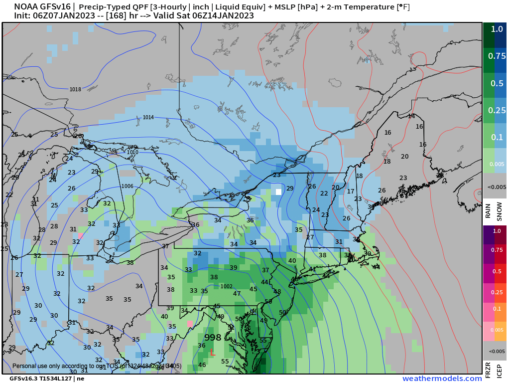
By Friday into Saturday, our next storm potential is showing up, and with no appreciable Arctic air waiting in the wings to be drawn into any coastal system, temps are marginal, and will tend towards mixed snow and rain events, and this one looks no different at the moment.
It’s a bunch of days away, but right now it looks like snow Friday night to rain into Saturday, so stay tuned for updates.
Have a great day!
You can also follow me on Twitter.
AND REMEMBER…
“Hello babies. Welcome to Earth. It’s hot in the summer and cold in the winter. It’s round and wet and crowded. On the outside, babies, you’ve got a hundred years here. There’s only one rule that I know of, babies: Goddamn it, you’ve got to be kind.”
–Kurt Vonnegut
