
Southeasterly wind gusts to 60mph possible Friday
——————————-
DAVE’S WEEKLY WEATHER NUTSHELL
–Gorgeous day today, seasonable 30s highs, sunny, light wind
–Partly cloudy tonight, lows teens, calm
–Thursday clouds up, a bit milder, rain (valley), snow and sleet (hills) arrives by dinner time
–Minor accumulations for first part of Thursday night
–Everybody flips to rain after midnight then it rains hard at times into Friday morning, wind picks up
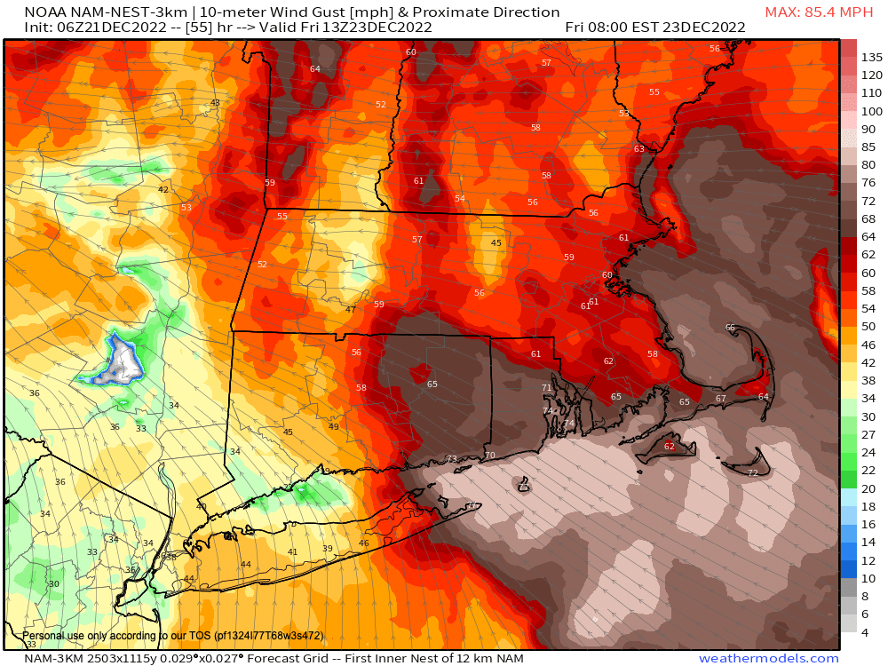
–Southeasterly gusts of 35-55mph expected, valley “disappointment triangle” may underperform with wind, lower range, highest wind highest elevation, up to 60mph, outages
–Final showers sweep through the afternoon, change to snow briefly, and quit, additional coatings possible
–West-southwest winds gust to 40mph as temps crash from 50s Friday into teens Friday night
–Cold Christmas Weekend, blustery Saturday, calmer XMas Day
–Fair weather early next week, milder temps, light snow possible by mid week
Now then, before we jump into the weather discussion/details below, let’s check a note from our local and delicious sponsor, #TandemBagelCo, with their newest location in West Springfield, MA.
——————–
A NOTE FROM OUR SPONSOR:
DHTWN Is Sponsored by Members, Patrons & Tandem Bagel Company: No matter the weather, Tandem Bagel is always there for you at several valley locations to make your mornings brighter! With bagels baked fresh daily (including Gluten-Free options), house-whipped cream cheese, coffee, and tons of lunch options, Tandem is the perfect quick stop for lunch, breakfast, or a coffee and bagel to go. Find them in Easthampton, Northampton, Hadley, Florence, and West Springfield, or use their super-streamlined online ordering tool by visiting their website.
——————————————-
***DHTWN DAILY WEATHER REPORT***
——————————————-
NWS ALERTS
None
DHTWN REMINDER
–The odds of being a human is 1 in 400,000 billion… make it count, even in a small way (see Kurt Vonnegut quote at end of post)
DAILY CELESTIAL (STAR):
–OUR STAR ROSE AT: 7:15am this morning
–OUR STAR WILL SET AT: 4:21pm this evening
–TOTAL DAYLIGHT TIME: 9 hours and 6 minutes
NIGHTLY CELESTIAL (MOON):
–OUR MOON WILL SET AT: 2:35pm this afternoon
–OUR MOON WILL RISE AT: 6:134am tomorrow morning
–MOON SET DIRECTION: West-Southwest
–MOON RISE DIRECTION: Southeast
–MOON PHASE: Waning Crescent (5.3%)
———————-
DAILY TERRESTRIAL (ZoneCast)
ZONE 1 (Northern Region)
Southern VT, Southwest NH, N. Taconics NY
–High Temps: Low to Mid 30s
–Low Temps: Mid to Upper 10s
–Wind: Light and variable
–Skies: Sunny
–Precipitation: None
ZONE 2 (Central Region)
WMass, N. CMass, N. Litchfield County, C./S. Taconics NY
–High Temps: Mid to Upper 30s
–Low Temps: Mid 10s to Low 20s
–Wind: Light and variable
–Skies: Sunny
–Precipitation: None
ZONE 3 (Southern Region)
S. CMass, S. Litchfield County, NC.CT, & NE.CT
–High Temps: Upper 30s
–Low Temps: Low 20s
–Wind: Light and variable
–Skies: Sunny
–Precipitation: None
———————-
WHERE’S DAVE?
–I’ve been reporting our weather daily here and at https://www.westernmassweather.com for almost 10 years
–Sign up for my free weekly newsletter here: https://westernmassweather.com/homepage/dhtwn-nutletter-signup/
–Please visit my this FB page via the app or web like selecting a channel you want to tune into if I’m not auto-kissing your screens
–I’m always here daily, so keep stopping by!
———————-
MORNING DISCUSSION
Good morning everybody, we’ve got high pressure overhead today and this will bring the star shine, and we shall face it (but not look directly at it because losing eyesight sucks) and rejoice!
It really will be lovely today, with sunshine, highs in the 30s, and a light wind, so no wind chill to speak of today.
Tonight is tranquil as well with lows in the teens and low 20s as clouds start to build in as we toward the New Moon and pass through the Winter Solstice just after sunset at 4:47pm EST.
For Thursday (after a hopefully colorful sunrise), we become overcast as a storm cranks up south of the Great Lakes and develops a strong warm frontal boundary that may see some lower pressure develop along as it swings its heavy-precipitation arm towards New England.
Highs will reach the upper 30s to low 40s, and mixed precipitation will arrive just after sunset in westernmost CT and MA.
Snow, sleet and rain begins, and we could see a coating to 2″ in the high terrain, whereas the valley is likely all rain, or mix. Then we all flip to rain by midnight, and it will rain hard overnight into Friday morning with potential for a thunderstorm as mild air surges up the eastern seaboard.
Lows Thursday night will drop to near freezing then rise toward morning, and continue climbing into the low to mid 50s for Friday highs.
We get the heavy rain slug first, then perhaps a bit of a lull towards later morning, and then a more showery presentation for the rest of the afternoon, with a final burst of rain changing back to snow late afternoon or early evening.
The wind setup is not so set in stone in terms of everybody no matter your elevation seeing the same level of southeasterly wind gusts.
There may be a bit of an inversion which knocks wind gusts down in the valley, but allows them to rip at higher elevations, especially above 1500 feet.
For now, I’d put the valley at gusts of 30-45mph, and the high terrain at 40-60mph, with a few gusts that may exceed 60mph, which means low-elevation outages could be more sporadic, and be more numerous higher up.
With 1 to 3″ of rain expected, some minor stream or street flooding could occur.
Also, the wind will shift to the west-southwest and gust 30-50mph Friday night into early Saturday, and even though a flash freeze is possible, the wind will be evaporating some of the surface water, so we’re not going to turn to an ice skating rink everywhere.
But, again, the high terrain with the current heavy snow pack will see rain AND snow melt, and it is these areas that could have some hazardous driving conditions later Friday evening, so be aware of that.
Highs 50s Friday go to lows in the teens late Friday night.
A blustery Saturday leads to a more tranquil Christmas Day but it will be cold all week with highs in the 20s and lows in the single digits.
Fair and more seasonable weather into middle of next week leads to potential light snow Clipper by Wednesday or Thursday, but generally quiet weather for next week, with moderate temps to above average by end of the week.
Have a great day, and if you missed the order deadline I still have my 2023 weather calendars with WMass photos at the link below: I won’t be doing one next year, so get ’em while you can!
Follow me on Twitter while it’s still a thing.
AND REMEMBER…
“Hello babies. Welcome to Earth. It’s hot in the summer and cold in the winter. It’s round and wet and crowded. On the outside, babies, you’ve got a hundred years here. There’s only one rule that I know of, babies: Goddamn it, you’ve got to be kind.”
–Kurt Vonnegut