
Snow elevation, rain valley for this Friday as it looks now.
——————————-
DAVE’S WEEKLY WEATHER NUTSHELL
–Fair weather week ahead, except for a stormy Friday
–Clearing today, highs low to mid 30s, breezy north wind
–Sunnier Tuesday and Wednesday, highs low to mid 30s
–Lows in the teens during this period, possible upper singles in northwest MA and SVT tonight
–Thursday. is partly sunny, with clouds increasing, 35-40º
–Snow and rain arrives Thursday night into Friday
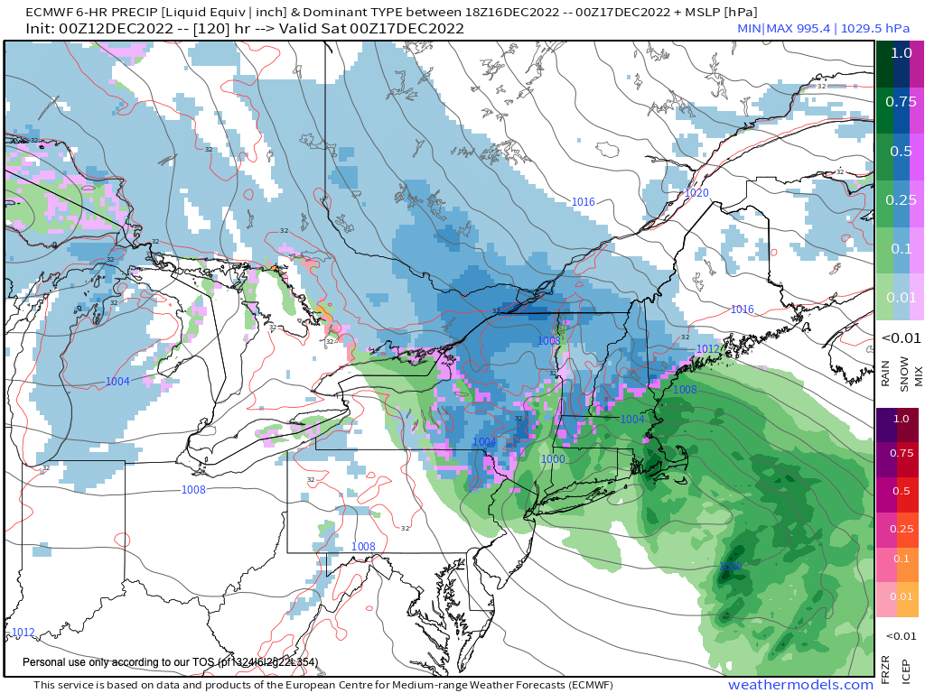
–Storm likely hugs the coast, but potential for heavy wet snow accumulations in parts of the Berkshires, western hilltowns and especially SVT where some outages will be possible
–Colder over the weekend with Saturday snow showers, and sunnier Sunday
–Stay tuned for potential track and impact changes for Friday’s storm
Now then, before we jump into the weather discussion/details below, let’s check a note from our local and delicious sponsor, #TandemBagelCo, with their newest location in West Springfield, MA.
——————–
A NOTE FROM OUR SPONSOR:
DHTWN Is Sponsored by Members, Patrons & Tandem Bagel Company: No matter the weather, Tandem Bagel is always there for you at several valley locations to make your mornings brighter! With bagels baked fresh daily (including Gluten-Free options), house-whipped cream cheese, coffee, and tons of lunch options, Tandem is the perfect quick stop for lunch, breakfast, or a coffee and bagel to go. Find them in Easthampton, Northampton, Hadley, Florence, and West Springfield, or use their super-streamlined online ordering tool by visiting their website.
——————————————-
***DHTWN DAILY WEATHER REPORT***
——————————————-
NWS ALERTS
–None
DHTWN REMINDER
–The odds of being a human is 1 in 400,000 billion… make it count, even in a small way (see Kurt Vonnegut quote at end of post)
DAILY CELESTIAL (STAR):
–OUR STAR ROSE AT: 7:09am this morning
–OUR STAR WILL SET AT: 4:18pm this evening
–TOTAL DAYLIGHT TIME: 9 hours and 9 minutes
NIGHTLY CELESTIAL (MOON):
–OUR MOON WILL RISE AT: 8:14pm this evening
–OUR MOON WILL SET AT: 11:16am tomorrow morning
–MOON RISE DIRECTION: East-Northeast
–MOON SET DIRECTION: West-Northwest
–MOON PHASE: Waning Gibbous (83.8%)
———————-
DAILY TERRESTRIAL (ZoneCast)
ZONE 1 (Northern Region)
Southern VT, Southwest NH, N. Taconics NY
–High Temps: Low to Mid 30s
–Low Temps: Upper Singles to Low 10s
–Wind: Light northerly wind, may gust to 15mph or so
–Skies: Cloudy early, then clearing w/ sunshine
–Precipitation: None
ZONE 2 (Central Region)
WMass, N. CMass, N. Litchfield County, C./S. Taconics NY
–High Temps: Low to Mid 30s
–Low Temps: Low to Mid 10s
–Wind: Light northerly wind, may gust to 15mph or so
–Skies: Cloudy early, then clearing w/ sunshine
–Precipitation: None
ZONE 3 (Southern Region)
S. CMass, S. Litchfield County, NC.CT, & NE.CT
–High Temps: Mid to Upper 30s
–Low Temps: Mid to Upper 10s
–Wind: Light northerly wind, may gust to 15mph or so
–Skies: Cloudy early, then clearing w/ sunshine
–Precipitation: None
———————-
WHERE’S DAVE?
–*I’ve been reporting our weather daily here and at https://www.westernmassweather.com for almost 10 years*
–Please visit my this FB page via the app or web like selecting a channel you want to tune into if I’m not auto-kissing your screens
–I’m always here daily, so keep stopping by!
———————-
MORNING DISCUSSION
Good morning everybody, thanks very much for all of your reports yesterday, and please do let me know how you did for snow totals. It seems like many of us ended up more in the upper half of that 2-5″ range, with a number of 6-7″ accumulations, and some 8″ in ones in the western hilltowns, Berkshires and northwest CT, with lesser amounts east and northeast.
Fortunately, it’s a fluffy lighter snow, so more easy to remove than heavy sopping wet snow pack.
Snow showers have left the building as our upper low is now east of Montauk and pulling away to the east-southeast.
We’ll be cloudy early, and then see sunshine developing as the day wears on, with highs reaching the low to mid 30s with a northerly breeze that may gust 15-20mph at times.
For tonight, the wind is expected to continue, but if it dies down, with fresh snow pack and exceedingly dry air in place and clear skies above, we could crash into the single digits to low teens for lows, setting us up for a frigid Tuesday morning!
Tuesday and Wednesday feature high pressure, sunshine, and highs in the upper 20s to mid 30s with lows in the teens to near 20º.
On Thursday, we will be watching a large area of low pressure push into the Ohio Valley, which will spread clouds into our region, despite the daytime being dry.
Expect partly sunny skies (more sun in the morning) with highs in the 35-40º range, with clouds thickening in the evening.
As of now, there is some agreement that the upper low pressure system associated with directing the track of our Ohio Valley surface low will be positioned further west near Michigan with high pressure northeast of us.
This could allow the storm to take a coastal-hugging track, which would introduce too much warm air aloft to keep us all snow in the Pioneer Valley and points east and south.
However, the exact track and strength (and precipitation onset time Thursday night into early Friday morning) will help determine Friday morning commute impacts across the region, and precipitation types and durations.
As of now, I’m becoming concerned for a heavy wet snowfall potential in parts of the Berkshires and western hilltowns up into southern VT and possibly east into the Monadnock Region of SWNH. This could cause some power outages, if it comes to pass, as this storm looks moisture-laden.
For the rest of WMass, CMass and northern CT, it looks like a front-end overnight snow thump to ice or rain setup into Friday, which could also have Friday morning commute impacts, but less so than in the high terrain mainly west of the I-91 corridor.
This could be one of those times you’re driving around the Look Park rotary and most cars are wet, but a few have 8″ of snow on them.
Highs Friday with snow and rain will be in the mid 30s to low 40s, and then the weekend looks colder in the 30s with partly sunny skies and mixed showers Saturday, and sunnier conditions for Sunday.
Stay tuned for daily updates, have a great day, and if you missed the order deadline, I still have 2023 weather calendars at the link below: I won’t be doing one next year, so get ’em while you can!
Follow me on Twitter while it’s still a thing.
AND REMEMBER…
“Hello babies. Welcome to Earth. It’s hot in the summer and cold in the winter. It’s round and wet and crowded. On the outside, babies, you’ve got a hundred years here. There’s only one rule that I know of, babies: Goddamn it, you’ve got to be kind.”
–Kurt Vonnegut