
Snow arrives by afternoon today
——————————-
WEEKLY WEATHER NUTSHELL
Top of the morning to you and yours! We’ve got morning flurries that give way to accumulating moderate to heavy snowfall later afternoon and tonight with fair weather Monday through the first half of Thursday before a larger and possibly more impactful storm system develops off the coast and brings snow, ice and rain to the region Thursday night into early Saturday morning, but before we dive into all of the weather details below, let’s check a note from our new local weekend sponsor, #CranberryHillHealingArts located in Amherst, MA.
——————–
A NOTE FROM OUR WEEKEND SPONSOR:
DHTWN is sponsored by members, patrons, and Cranberry Hill Healing Arts. The turning of the seasons can be challenging, and Carolyn Walker of Cranberry Hill Healing Arts in Amherst is there for you. When you are searching for ways to be at peace, seek relaxation, and feel more energetic, let Reiki & Sound Healing guide you on your journey to wholeness. Through energy work and the gentle vibrations of singing bowls, chimes, and chanting, Carolyn crafts a safe and calming space to experience renewal. Learn more and/or book your session today by visiting her website.
——————————————-
***DHTWN DAILY WEATHER REPORT***
——————————————-
Good morning everybody, well I realize this is a day that many do not relish, enjoy, or get excited about, but truth be told, I was away during mid-November, reporting from Martha’s Vineyard during a very brief but much needed getaway, so I missed the first snow of the incoming cold season.
As a massive snow lover since I was 8 years old, today is my first snow of 2022-23 winter season, and I am excited for a substantial-enough blanket of dendrites by tomorrow morning.
NERD/NUT ALERT
This not a moisture-laden system, as it will not be drawing on ocean air much except for late in its development, but the much colder air aloft and the rising air associated with its upper low to the west will encourage the air to rise up and into a fairly saturated (i.e. humid) DGZ or dendritic growth zone, which is a layer that varies in elevation and is very cold between -12ºC to -18ºC. This rising air into this zone usually produces moderate to heavy bands of dendrites, which are the 3-D pretty snowflakes that stack well (i.e. accumulate).
So what, Dave?
This is why we’re going to see periods of moderate to heavy snow late afternoon and this evening that could reach rates of 0.5″-1.0″ per hour intensity, causing slippery travel, so if you have to be out tonight, give yourself plenty of time
CAUTION: FIRST SNOW OF THE YEAR
Take it easy on the roads, none of us have our “snow legs” under us yet, despite how many decades of winter driving experience we have.
The first steady/heavy snow falls of the year always result in numerous accidents, so don’t be one of those people, if you can help it, take it easy on the roads, speed up slowly, slow down slowly, turn a bit more slowly, etc.
BASICS
Basics: Highs today reach the upper 20s to mid 30s, with lows in the low to mid 20s.
This one is all snow, folks!!
SETUP
Our upper level low in the Great Lakes slides into NY and dives southeast with the surface low toward Long Island tonight.
Flurries are already developing in eastern NY and likely. spreading into the Berkshires or LItchfields soon if they haven’t already, as humidity is already increasing.
NO-NONSENSE ALERT:
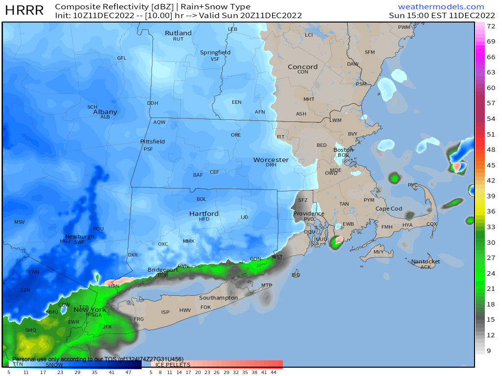
SNOW TIMING AND AMOUNTS
Snow becomes light/steadier by late morning into early afternoon across WMass, northwest CT and SVT, and then spreads east into southwest NH, CMass, and northeast CT by mid afternoon or so.
Snow will fall moderately to heavily at times by this evening.
Winter Weather Advisories expanded into Tolland County CT, and continue for WMass, northwest CT and the Taconics of eastern NY where a widespread 2-5” of snow should accumulate.
I believe we’ll see a 4-7” possible swath in western Hampden/Hampshire, eastern Berkshires and northeast Litchfield County.
Southern VT is tricky with 1-4″ (less north, more south), and possible 4″+ amounts in some parts of the southern Greens, especially in Bennington County.
We should see more like 1-3” in CMass, northeast CT and southwest NH (lower range north and east, higher range south and west).
The brunt of the storm is 4pm-Midnight, then we taper through the pre-dawn hours, with a few lingering flurries in southwest MA or northern CT by dawn Monday morning.
MONDAY TO THURSDAY: FAIR AND COLD
This period features true winter conditions, with highs in the low to mid 30s and lows in the teens, and in fact, Monday night into Tuesday morning with fresh snow pack may result in lows in the single digits for some!
Anyway, it’s mostly sunny, clear at night, and cold and dry.
MAJOR LATE-WEEK WINTER STORM?
It continues to look like the late Thursday night into early Saturday morning period (read: Friday looks lousy) will feature a coastal storm that could bring a wide variety of precipitation types to the region.
HILLTOWNER ALERT: This storm on Friday could bring a major snowstorm to the Berkshires, southern VT, southwest NH, and the western hilltowns into the Rt. 2 corridor, so stay tuned for updates on this upcoming system.
For now, have a great day, and I will update you by early afternoon with another report near or just after sunset as our storm moves in today… and if you missed the order deadline, I still have 2023 weather calendars at the link below, I won’t be doing one next year, so get ’em while you can!
You can also follow me on Twitter.
AND REMEMBER…
“Hello babies. Welcome to Earth. It’s hot in the summer and cold in the winter. It’s round and wet and crowded. On the outside, babies, you’ve got a hundred years here. There’s only one rule that I know of, babies: Goddamn it, you’ve got to be kind.”
–Kurt Vonnegut