
Sunday snow on the way
——————————-
WEEKLY WEATHER NUTSHELL
Top of the morning to you and yours! We’ve got a sweet, sunny and colder Saturday followed by a cloudy and eventually snowy Sunday afternoon and night (1-3″ valley, 2-5″ western hills and Berkshires/Litchfields) with fair and cold early to mid week period with another snowstorm possible by Friday, but before we dive into all of the weather details below, let’s check a note from our new local weekend sponsor, #CranberryHillHealingArts located in Amherst, MA.
——————–
A NOTE FROM OUR WEEKEND SPONSOR:
DHTWN is sponsored by members, patrons, and Cranberry Hill Healing Arts. The turning of the seasons can be challenging, and Carolyn Walker of Cranberry Hill Healing Arts in Amherst is there for you. When you are searching for ways to be at peace, seek relaxation, and feel more energetic, let Reiki & Sound Healing guide you on your journey to wholeness. Through energy work and the gentle vibrations of singing bowls, chimes, and chanting, Carolyn crafts a safe and calming space to experience renewal. Learn more and/or book your session today by visiting her website.
——————————————-
***DHTWN DAILY WEATHER REPORT***
——————————————-
Good morning, and welcome to the new folks who arrived through the Masslive article on the Western Mass Snow Lover’s Triangle of Disappointment.
I post every day here, so if I don’t smooch your screens passively each day, with just a couple clicks more you’ll find my reports here daily, unless I get a kidney stone or reach spiritual enlightenment and evaporate into the Cosmos spontaneously!
For today, we have GIANT high pressure due north of us over Hudson Bay and southeastern Canada pressing southward and providing fair weather and mostly sunny skies for much of the greater WMass region, except for northeast CT and southeast Worcester County (the eastern parts of my main coverage area) where onshore flow will produce partly sunny skies, sometimes with more low clouds than sun there.
Highs today will reach the mid to upper 30s, and winds should be light northeasterly.
For tonight, low clouds from onshore flow will increase into our eastern zones (CMass, northeast CT) and mid and high level clouds from our Clipper low to the west will increase into our western zones (Berkshires, Taconics, Litchfields, SVT).
Lows will drop into the low to mid 20s, establishing a solid dome of cold air across the region, which will ensure that our Sunday P.M. precipitation falls in the form of snow.
For Sunday, clouds thicken at all levels with overcast skies, so look for what I call that “silvery snow sky” which I personally love, because I’m a winter weather freakazoid #SorryNotSorry
Sunday is going to be cold, folks, as in upper 20s to mid 30s for highs cold, and is going to be our first fully winter day, which is quite timely as we are only days away from the Winter Solstice which passes at 4:47pm on Wednesday, December 21st (a week from this Wednesday).
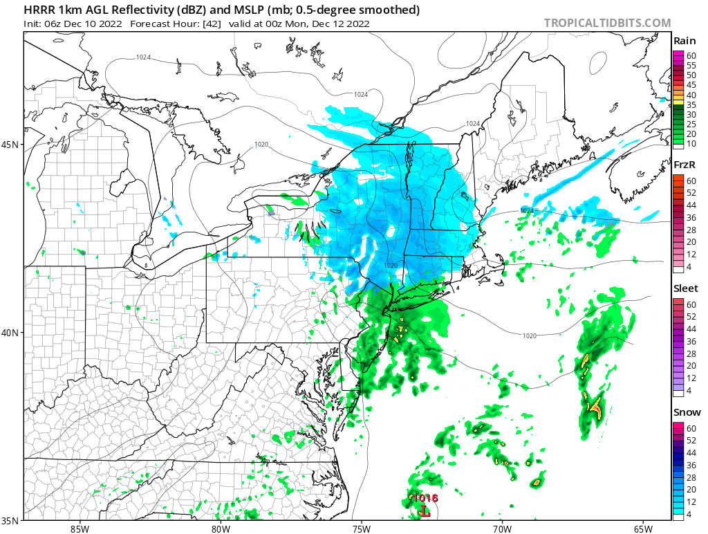
SNOW ARRIVAL TIMING
Flurries or lighter snow showers could reach us by noon or early afternoon, but steadiest and heavier snow should arrive late afternoon, and especially in the evening and through midnight into the pre-dawn hours before quitting by Monday morning.
This storm has tended a bit more on the robust side of things with a little bit more moisture, and notably colder upper and mid level air moving in as the storm tracks southeast through NY state and near Long Island.
This sharper temperature (or “thermal) gradient of less-cold air lower in the atmosphere and more-cold air higher up above it will induce more sharply rising air producing some moderate to briefly heavy bands of snow, which likely sets up in northwest CT, the western hilltowns of WMass and eastern Berkshires closest to storm track.
SNOW AMOUNTS
The overall limitation of moisture and fast-moving nature of the storm will prevent it from being a widespread moderate to major snowfall, but all of us should see at least 1-3″, with areas like the eastern Berkshires, western hilltowns, southernmost Green Mountains in VT (southeast Bennington and southwest Windham Counties) and northern Litchfield County with 2-5” of accumulation. Areas like far northeast CT and eastern CMass may see more like a coating to an inch or so of snow.
Snow quits by Monday morning, and then high pressure moves in to provide a cold and fair weather period lasting from at least Monday through Wednesday with highs in the low to mid 30s and lows in the upper teens to low 20s.
Thursday likely starts off dry, but then we watch to see how a stronger and more complex low pressure system develops and is steered by upper level energy to its north and northwest.
This storm still has the potential to become a strong nor’easter with plenty of snow for the southern New England region, but we’re still 5-6 days away, so for now, we watch and monitor, and I will keep you updated on it, as well as tomorrow evening’s storm.
One thing seems to be for sure at the moment, and that’s that Winter is starting to settle in more deeply as we approach the Solstice.
Have a great day, stay tuned for daily updates, and if you missed the order deadline, I still have 2023 weather calendars at the link below, I won’t be doing one next year, so get ’em while you can!
You can also follow me on Twitter.
AND REMEMBER…
“Hello babies. Welcome to Earth. It’s hot in the summer and cold in the winter. It’s round and wet and crowded. On the outside, babies, you’ve got a hundred years here. There’s only one rule that I know of, babies: Goddamn it, you’ve got to be kind.”
–Kurt Vonnegut