
Incoming cold front brings rain/wind today.
Top of the morning to you and yours! If the all-caps headlines don’t float your boat, I’m batting summarizational clean-up down in the Nutshell as we have rain this morning, rain and wind this afternoon quitting by early evening with colder/sunnier climes Sunday and Monday, milder and rainier conditions into mid-week to be followed by colder conditions late week and potential for the following Sunday night to feature snow, but before we dive into all of the weather details below, let’s check a note from our new local weekend sponsor, #CranberryHillHealingArts located in Amherst, MA.
——————–
A NOTE FROM OUR WEEKEND SPONSOR:
DHTWN is sponsored by members, patrons, and Cranberry Hill Healing Arts. The turning of the seasons can be challenging, and Carolyn Walker of Cranberry Hill Healing Arts in Amherst is there for you. When you are searching for ways to be at peace, seek relaxation, and feel more energetic, let Reiki & Sound Healing guide you on your journey to wholeness. Through energy work and the gentle vibrations of singing bowls, chimes, and chanting, Carolyn crafts a safe and calming space to experience renewal. Learn more and/or book your session today by visiting her website.
——————————————-
***DHTWN DAILY WEATHER REPORT***
——————————————-
We’ve got seesaw weather continuing as we’ve entered Meteorological Winter (Dec. 1 through Feb. 28), but we’re New Englanders and we roll with whatever comes our way, for cripes sake (as my Nana used to say back in the day)!
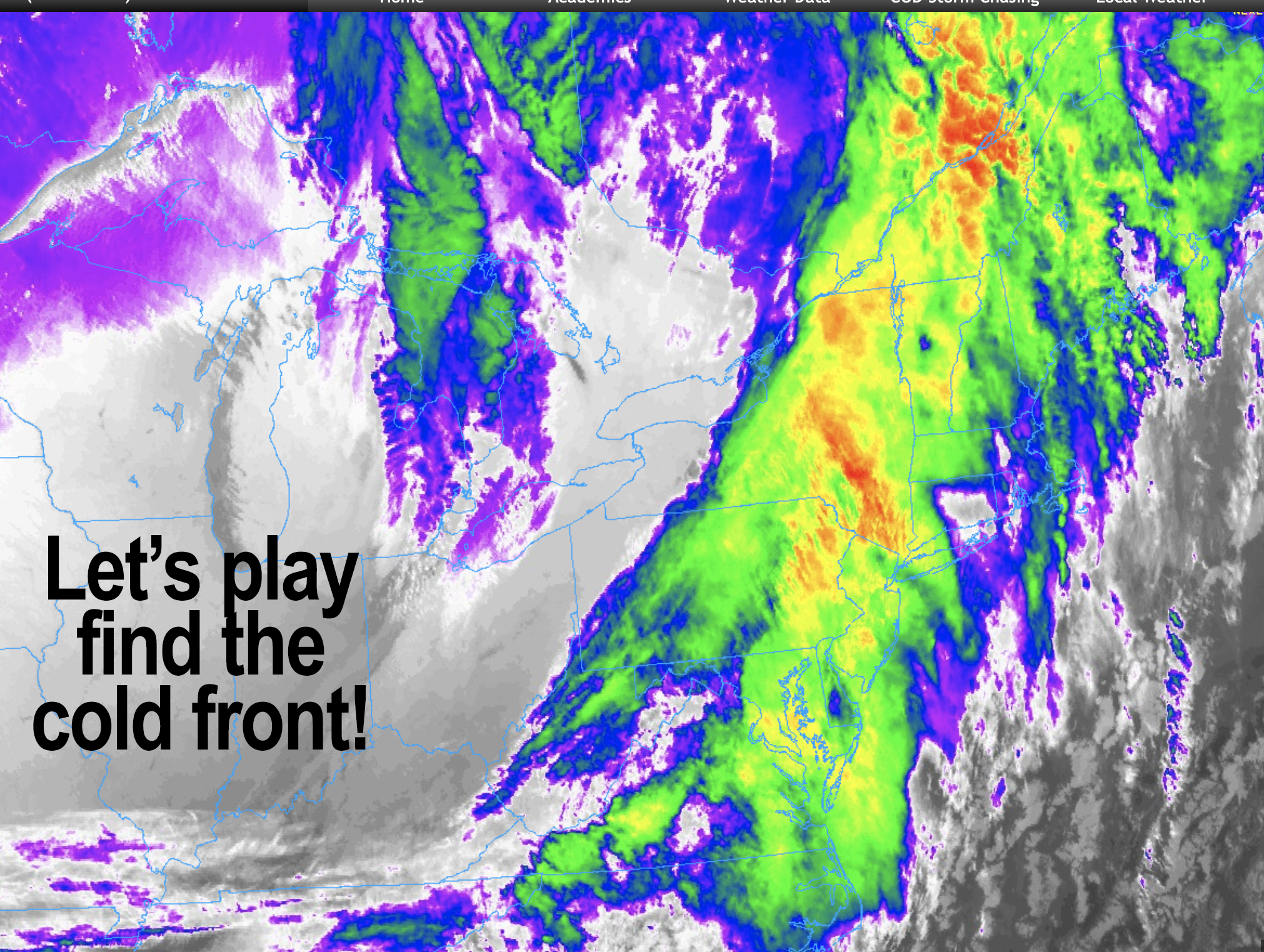
For today, we have a strong Great Lakes storm sweeping northeast into Quebec, and it is dragging its cold front our way ahead of milder air which is moving into the region this morning.
Unlike a few days ago, we’re ALREADY milder to start the day, so we will warm up sooner, and the inversion aloft (colder air at surface, warmer above which is an inversion of how air temps setup usually), appears to be weaker.
These two factors should combine with a low level jet streak out of the southwest mixing down gusty southwesterlies of 25-40mph today, mostly this afternoon and evening ahead of the frontal passage. Some gusts may be over 40mph, so an isolated outage could occur.
Showers are already scattered about, but fill in from 10am to noon or 1pm from southwest to northeast, and rain could fall pretty heavily at times.
Highs will reach the low to mid 50s, and we should get a break in the action sometime between 1-3pm from west to east, with a final line of convective showers just after sunset between 5-7pm moving west to east, bringing briefly heavy rain, and possible gusty winds.
For tonight, winds veer from southwest to northwest behind the front and gust up to 25mph or so, with low temps cooling down into the upper 20s to low 30s as the stars of the Milky Way Galaxy start to reappear.
Winds could last into the the morning hours, but should be on the wane with sunshine on the wax. However, cooler Canadian air will replace today’s mild air with highs only in the 30s, followed by lows in the upper teens to 20s with radiational cooling taking effect.
Monday looks lovely but cool, with sunshine and highs in the low to mid 40s as clouds increase at night ahead of our next frontal passage.
The Tuesday through Thursday period looks to feature milder than average temps as a broader surge of mild air from the south is pulled into the region from a storm passing well north of us.
Highs should range from the upper 40s to low to mid 50s during this period with lows near freezing, and showers Tuesday into Wednesday.
A cold front moves through sometime around Wednesday night or Thursday first part of the day, which allows colder air to work back into the region late week with sunshine returning by that time.
The general pattern still favors inside runners, that means storms that track inland away from the east coast, and hence they stay to our northwest and keep us on the milder side, with mostly rain.
However, when these storms move in overnight and it’s cold enough, they can start as snow or ice, and this may happen during the following Sunday night into the following Monday morning (8 to 9 days from now) so stay tuned for updates as we get closer to that event.
Have a great day, and if you’d like to support my work here, I’m selling two fun designs of very comfy cold-season apparel (sale ends Tomorrow Night), and I still have extra 2023 weather calendars left, just click a link below, and thank you!
#1: WMASS SNOW LOVERS’ TRIANGLE OF DISAPPOINTMENT (sale ends tomorrow night)
#2: WHAT DOES DAVE SAY? (Sale ends tomorrow night)
#3: 2023 Weather Calendars (ships next week)
You can also follow me on Twitter.
AND REMEMBER…
“Hello babies. Welcome to Earth. It’s hot in the summer and cold in the winter. It’s round and wet and crowded. On the outside, babies, you’ve got a hundred years here. There’s only one rule that I know of, babies: Goddamn it, you’ve got to be kind.”
–Kurt Vonnegut