
——————————-
DAVE’S WEEKLY WEATHER NUTSHELL
–A beautiful, calm, mostly sunny and seasonable Tuesday, highs low/mid 40s
–Clouds build tonight, a few showers possible later Wednesday morning
–Wind Advisories are up for CMass, likely to expand into parts of WMass region
–Mild Wednesday afternoon with heavy rain at times into the evening, highs in the 50s
–Strong southerlies develop and gust 35-50mph, some isolated outages possible
–Cold front passes Wednesday evening with burst of strong wind around dinner time, then gusty northwesterlies into Thursday with scattered snow showers possible, coatings Berkshires
–Calmer Friday, sunny
–More rain and wind Saturday, nicer Sunday, more rain by next Tuesday, active pattern continues!
Before we jump into the weather discussion/details below, let’s check a note from our local and delicious sponsor, #TandemBagelCo, with their newest location in West Springfield, MA.
——————–
A NOTE FROM OUR SPONSOR:
DHTWN Is Sponsored by Members, Patrons & Tandem Bagel Company: No matter the weather, Tandem Bagel is always there for you at several valley locations to make your mornings brighter! With bagels baked fresh daily (including Gluten-Free options), house-whipped cream cheese, coffee, and tons of lunch options, Tandem is the perfect quick stop for lunch, breakfast, or a coffee and bagel to go. Find them in Easthampton, Northampton, Hadley, Florence, and West Springfield, or use their super-streamlined online ordering tool by visiting their website.
——————————————-
***DHTWN DAILY WEATHER REPORT***
——————————————-
NWS ALERTS
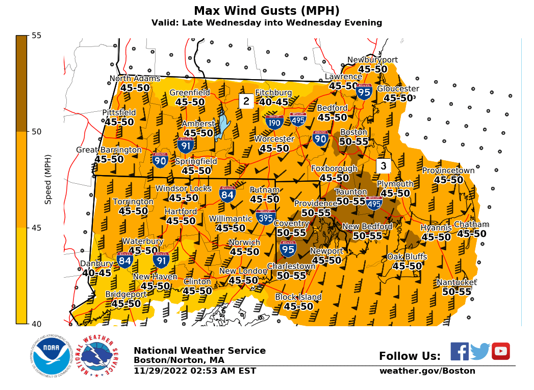
–Wind Advisories are up for Worcester County for Wednesday afternoon/evening, may be expanded
DHTWN REMINDER
–The odds of being a human is 1 in 400,000 billion… make it count, even in a small way (see Kurt Vonnegut quote at end of post)
DAILY CELESTIAL (STAR):
–OUR STAR ROSE AT: 6:56am this morning
–OUR STAR WILL SET AT: 4:20pm this evening
–TOTAL DAYLIGHT TIME: 9 hours and 24 minutes
NIGHTLY CELESTIAL (MOON):
–OUR MOON WILL SET AT: 10:39pm tonight
–OUR MOON WILL RISE AT: 12:51pm tomorrow afternoon
–MOON SET DIRECTION: West-Southwest
–MOON RISE DIRECTION: East-Southeast
–MOON PHASE: Waxing Crescent (37.6%)
———————-
DAILY TERRESTRIAL (ZoneCast)
ZONE 1 (Northern Region)
Southern VT, Southwest NH, N. Taconics NY
–High Temps: Mid 30s to Low 40s
–Low Temps: Mid to Upper 20s
–Wind: Calm
–Skies: Mostly Sunny
–Precipitation: None
ZONE 2 (Central Region)
WMass, N. CMass, N. Litchfield County, C./S. Taconics NY
–High Temps: Low to Mid 40s
–Low Temps: Upper 20s to Low 30s
–Wind: Calm
–Skies: Mostly Sunny
–Precipitation: None
ZONE 3 (Southern Region)
S. CMass, S. Litchfield County, NC.CT, & NE.CT
–High Temps: Low to Mid 40s
–Low Temps: Low 30s
–Wind: Calm
–Skies: Mostly Sunny
–Precipitation: None
———————-
MORNING DISCUSSION
Good morning everybody, we’ve got a lovely and literal calm before the storm today, with a true blast of wind and rain coming through to clean our regional clocks tomorrow afternoon and evening, lasting into Thursday as the air mass changes from cool to much milder to cool again.
For today, high pressure slides through the eastern seaboard and brings a calm, mostly sunny and seasonable Tuesday with highs in the upper 30s to mid 40s from north to south, with clouds increasing tonight as lows drop quickly at sunset and then hold steady around the upper 20s to low 30s.
For Wednesday, we’ll have a powerful storm system tracking well northwest of us as it draws copious moisture and wind energy up the east coast and into New England.
This setup will push a warm front through the region by late morning and some initial showers scattered about may track south to north into our region.
As temps spike into the low to mid 50s by early Wednesday afternoon and we enter the warm sector ahead of the incoming cold front, southerly wind gusts of 35-50mph should develop during the afternoon along with periods of heavier showers.
Some power outages will be possible, and Wind Advisories will probably be expanded into parts of the WMass region.
So, expect a windy and rainy Wednesday afternoon and evening. As the cold front moves through around dinner time, we could get a spike in wind that may cause isolated damage or outages, and then our wind will veer around to the west and northwest, and gust 25-40mph overnight into Thursday as we cool back down and dry out.
Anywhere between half an inch to an inch of rainfall looks possible with this fast-moving system.
In addition, some of us should see some snow showers after midnight into Thursday morning, especially in the Berkshires, western hilltowns and southern VT, with some coatings possible and isolated areas up to an inch or snow not out of the realm of possibility.
Thursday is blustery and cold with highs in the mid 30s to low 40s and wind chills in the 20s, again with northwest winds gusting 25-40mph.
Winds slacken by nightfall, with lows in the low to mid 30s, with a very pleasant end to the week expected on Friday with highs in the low to mid 40s under sunny skies.
However, that is short lived as another weaker front moves through Saturday with more showers and possibly some wind preceding it as highs climb into the low 50s with southerly flow.
Sunday is the pick of the weekend, with breezy conditions and sunshine producing highs into the 40s, which will continue into Monday.
Then, ANOTHER frontal system moves into the region with even more rain on Tuesday.
Things feel like they are changing, especially given that a blocking high pressure system up near Greenland and a weaker tropospheric polar vortex could allow colder air to pool and spill into New England by mid-December with said blocking high pressure keeping it locked in here for a bit.
I wouldn’t be surprised if we had white Christmas this year, but we shall see.
Have a great day, and please check out what I’m calling my “Cozy’n’Warm” Holiday Apparel Sale with 2 new hoodie, sweatshirt, long/short-sleeve shirt designs to keep you and yours warm this cold season, please browse below!
#1: WMASS SNOW LOVERS’ TRIANGLE OF DISAPPOINTMENT
Have a great day folks!
Follow me on Twitter while it’s still a thing.
AND REMEMBER…
“Hello babies. Welcome to Earth. It’s hot in the summer and cold in the winter. It’s round and wet and crowded. On the outside, babies, you’ve got a hundred years here. There’s only one rule that I know of, babies: Goddamn it, you’ve got to be kind.”
–Kurt Vonnegut