
__________________________________
2023 WEATHER WALL CALENDAR AVAILABLE TO ORDER:
–Serene and gorgeous local WMass photos
–Deep-dives into the Top 12 most remarkable regional storm histories, personal stories, and the under-the-hood meteorology that created them
–12 weather-themed haiku
–Featured article on how the Sun drives Earth’s weather, and so much more!
2023 CALENDAR SECURE ORDER/INFO LINK
Good morning folks, we’ve got patchy fog out there along with some morning showers mainly east of the I-91 corridor. These will lift northeast and away through the morning with clearing later and tonight, to be followed by a cool mid-week period featuring some morning frost which then fosters milder temps through the weekend with mostly sunny skies throughout and a few showers by early next week, but before we jump into the details, let’s check a note from our local and delicious sponsor, #TandemBagelCo, with their newest location in West Springfield, MA.
——————–
A NOTE FROM OUR SPONSOR:
DHTWN Is Sponsored by Members, Patrons & Tandem Bagel Company: No matter the weather, Tandem Bagel is always there for you at several valley locations to make your mornings brighter! With bagels baked fresh daily (including Gluten-Free options), house-whipped cream cheese, coffee, and tons of lunch options, Tandem is the perfect quick stop for lunch, breakfast, or a coffee and bagel to go. Find them in Easthampton, Northampton, Hadley, Florence, and West Springfield, or use their super-streamlined online ordering tool by visiting their website.
——————————————-
***DHTWN DAILY WEATHER REPORT***
——————————————-
NWS ALERTS
–Frost Advisory for southern Litchfield County CT
DHTWN REMINDER
–The odds of being a human is 1 in 400,000 billion… make it count, even in a small way (see Kurt Vonnegut quote at end of post)
DAILY CELESTIAL (STAR):
–OUR STAR ROSE AT: 7:06am this morning
–OUR STAR WILL SET AT: 6:03pm this evening
–TOTAL DAYLIGHT TIME: 10 hours and 57 minutes
DAILY CELESTIAL (MOON):
–OUR MOON WILL SET AT: 3:17pm this afternoon
–OUR MOON WILL RISE AT: 12:37pm tomorrow morning
–MOON SET DIRECTION: West-Northwest
–MOON RISE DIRECTION: East-Northeast
–MOON PHASE: Waning Crescent (43.2%)
———————-
DAILY TERRESTRIAL (ZoneCast)
ZONE 1 (Northern Region)
Southern VT, Southwest NH, N. Taconics NY
–High Temps: Low to Mid 50s
–Low Temps: Low to Mid 30s
–Wind: Calm/Light
–Skies: Clouds early, transitioning to mostly sunny this afternoon
–Precipitation: A few showers mainly in southwest NH, then drying
ZONE 2 (Central Region)
WMass, N. CMass, N. Litchfield County, C./S. Taconics NY
–High Temps: Mid to Upper 50s
–Low Temps: Low to Mid 30s
–Wind: Calm/Light
–Skies: Clouds early, transitioning to mostly sunny this afternoon
–Precipitation: Periods of showers mainly east of the I-91 this morning, then drying and clearing by afternoon
ZONE 3 (Southern Region)
S. CMass, S. Litchfield County, NC.CT, & NE.CT
–High Temps: Mid to Upper 50s
–Low Temps: Low to Mid 30s
–Wind: Calm/Light
–Skies: Clouds early, transitioning to mostly sunny this afternoon
–Precipitation: A few showers mainly in northeast CT, then drying and clearing
———————-
WEATHER REPORT
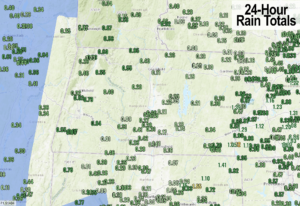
Good morning everybody, as you can see in the attached chart some of us got a pretty good drink of rain last night, all of which is great to lay into the ground and water table before the cold season really clamps down on our region.
As expected, jackpot was east of the CT River, especially in northeast CT where up to 1.5″ fell.
As for this morning, we have some showers that will continue in northeast up into eastern parts of WMass and CMass and we may see one more batch of showers regenerate and push into these similar areas as our cold front is slow to depart east this morning.
Eventually by afternoon, all rain should ship out and we’ll break into partly to mostly sunny skies with highs in the afternoon with highs in the low to mid 50s.
Any light winds should go calm tonight, and with clearing skies and drier air working into the region, radiational cooling will cast any surface heat Space-ward, and we’ll be left with lows in the upper 20s to mid 30s with frost expected in many places.
The growing season has officially ended for most of my coverage area, so NWS doesn’t post Frost or Freeze warnings/advisories going forward, but that doesn’t mean it won’t frost over the next couple of nights. Southern Litchfield is the furthest southwest in my coverage area, which has a Frost Advisory hoisted.
For tomorrow, high pressure starts to nudge in as our big meandering low gyre over the Great Lakes tracks a bit east and then northeast and away into Canada through this week, but hey, that puppy brought some good rainfall to the area, so thanks buddy!
As it does so, and as high pressure noses in from the southwest, a pressure gradient will form and kick up southwesterly gusts with wind sourced from colder Canada, which is unusual.
Therefore, we’ll see mostly sunny skies Wednesday and Thursday, along with southwesterly gusts up to 25mph at times, but with temps only in the upper 40s to mid 50s from north to south. Lows will be in the low to mid 30s under mostly clear skies with patchy frost possible.
By Friday, our big Great Lakes low is off to take a permanent vacation over Hudson Bay while our high pressure moves through the region and we start to undergo the seasons first Mildening event.
Highs will reach the 55-60º range Friday under sunny skies with lows in the mid to upper 30s, but just you wait for the weekend!
Another winner to be sure, with highs warming into the mid to upper 60s with lows in the 40s and plenty of sunshine, woo hoo!!
Early next week will start off sunny, but the high pressure’s influence will be waning in our region, and by Tuesday into mid week we could see a coastal system bring some more rain showers chances to the greater WMass region, but only after many fair weather days.
Have a great day, and if you like my work you can support it by buying one or three of my 2023 calendars… it’s a great local-color-filled daily companion, this year with tons of cool local storm history, and it’s great for holiday gifts too!
2023 CALENDAR SECURE ORDER/INFO LINK
Did you know that you can also follow me on Twitter?
AND REMEMBER…
“Hello babies. Welcome to Earth. It’s hot in the summer and cold in the winter. It’s round and wet and crowded. On the outside, babies, you’ve got a hundred years here. There’s only one rule that I know of, babies: Goddamn it, you’ve got to be kind.”
–Kurt Vonnegut