
__________________________________
2023 WEATHER WALL CALENDAR AVAILABLE TO ORDER:
–Deep-drive into the Top 12 most remarkable/impactful regional storm histories, stories, and the under-the-hood meteorology that made them memorable!
–Serene and gorgeous local photos
–My weather-themed haiku
–Featured article on how the Sun drives Earth’s weather, and much more!
SECURE 2023 CALENDAR ORDER/INFO LINK
Good morning folks, we still have have some showers moving through the region from south to north, and with time these will exit. The cold front is currently in eastern Worcester County with heavier rain there, and it slowly moving east.
After clearing tonight we have a beautiful weekend ahead with more rain showers Monday into Monday night and possibly lasting into early Tuesday morning with a few snow showers in the western high terrain, followed by a cooler but more fair weather mid to late week period , but before we jump into the details, let’s check a note from our local and delicious sponsor, #TandemBagelCo, with their newest location in West Springfield, MA.
——————–
A NOTE FROM OUR SPONSOR:
DHTWN Is Sponsored by Members, Patrons & Tandem Bagel Company: No matter the weather, Tandem Bagel is always there for you at several valley locations to make your mornings brighter! With bagels baked fresh daily, house-whipped cream cheese, coffee, and tons of lunch options, Tandem is the perfect quick stop for lunch, breakfast, or a coffee and bagel to go. Find them in Easthampton, Northampton, Hadley, Florence, and West Springfield, or use their super-streamlined online ordering tool by visiting their website.
——————————————-
***DHTWN DAILY WEATHER REPORT***
——————————————-
NWS ALERTS
–Flood Watches expire this morning, Wind Advisories in SVT/NBerks already were inactivated
DHTWN REMINDER
–The odds of being a human is 1 in 400,000 billion… make it count, even in a small way (see Kurt Vonnegut quote at end of post)
DAILY CELESTIAL (STAR):
–OUR STAR ROSE AT: 7:01am this morning
–OUR STAR WILL SET AT: 6:10pm this evening
–TOTAL DAYLIGHT TIME: 11 hours and 9 minutes
DAILY CELESTIAL (MOON):
–OUR MOON WILL RISE AT: 8:55pm tonight
–OUR MOON WILL SET AT: 1:06pm tomorrow afternoon
–MOON RISE DIRECTION: Northeast
–MOON SET DIRECTION: Northwest
–MOON PHASE: Waning Gibbous (79.4%)
———————-
DAILY TERRESTRIAL (ZoneCast)
ZONE 1 (Northern Region)
Southern VT, Southwest NH, N. Taconics NY
–High Temps: Upper 50s to Mid 60s
–Low Temps: Upper 30s to Low 40s
–Humidity: Drying by tonight
–Wind: Northwest wind gusts to 20mph possible
–Skies: Mostly Cloudy early, partly to mostly sunny by afternoon
–Precipitation: Some morning showers should quit by late morning or noon
ZONE 2 (Central Region)
WMass, N. CMass, N. Litchfield County, C./S. Taconics NY
–High Temps: Low 60s to Mid 60s
–Low Temps: Upper 30s to Mid 40s
–Humidity: Drying by tonight
–Wind: Northwest wind gusts to 20mph possible
–Skies: Mostly Cloudy early, mostly sunny west and partly sunny east by afternoon
–Precipitation: Some morning showers should quit by late morning or noon
ZONE 3 (Southern Region)
S. CMass, S. Litchfield County, NC.CT, & NE.CT
–High Temps: Mid to Upper 60s
–Low Temps: Mid 40s
–Humidity: Drying by tonight
–Wind: Northwest wind gusts to 20mph possible
–Skies: Mostly Cloudy early, mostly sunny west and partly sunny east by afternoon
–Precipitation: Some morning showers should quit by late morning or noon
———————-
WEATHER REPORT
Good morning everybody, many of us ended up with a good drink of rain more in the half inch to 2″ range, but those heaviest totals up to 3″ were far and few between.
Also of note was the wind gusts out of the southeast. We definitely hit the 25-40mph range I had mentioned with a peak gust of 43mph at Sturbridge, MA, but that was during the early part of the event. The heavy rain and cold front produced little fanfare, with a 31mph gust noted at Worcester Airport as it passed through a little while ago.
What’s that? You want double dashes? Me too, as it so happens!
–Scattered showers and mist this morning gives way to drying and increase sunshine by late morning into the afternoon, earlier west, later east
–Highs will reach the 60s for the most part, lower 60s in our northern zones, upper 60s in our southern zones
–Northwest winds may gust up to 20mph behind the front
–Clearing tonight with lows in the upper 30s to mid 40s
–The weekend looks gorgeous with sunshine both days (though a bit more clouds on Sunday especially in the afternoon)
–Saturday is the weekend pick with highs in the mid 60s under sunny skies, with lows in the low to mid 40s with clear skies
–Sunday looks mostly sunny as high pressure continues to build in with highs low to mid 60s, and then clouds will increase with a few showers late Sunday night with lows in the low 40s
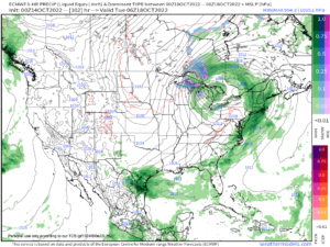
–Yet another low center and warm/cold frontal combo system will be ejected out of the cutoff upper low gyre rotating (and not moving much) over the Great Lakes region
–This storm will track to our north and bring both fronts through the region Monday and Monday night with periods of showers at times, which could produce some more substantial rain, though not as much as last night
–Highs Monday will only reach the mid to upper 50s with lows in the upper 30s to low 40s
–There’s a low chance for the southern Greens in VT to see first snowflakes by the pre-dawn hours Tuesday morning, but that idea is looking less plausible
–Tuesday should see a few parting showers with highs in the upper 40s to mid 50s behind the front – chilly!
–Lows will be in the low to mid 30s with more frost possible
–Then we stay cooler in the 40s to low 50s or so for the rest of the week with fair weather, and near freezing temps each night
Have a great day, and please check out my 2023 calendar, it’s a great local-color-filled daily companion, you’ll learn a bunch of cool local weather history, and it’s great for holiday gifts too!
SECURE 2023 CALENDAR ORDER/INFO LINK
Did you know that you can also follow me on Twitter?
AND REMEMBER…
“Hello babies. Welcome to Earth. It’s hot in the summer and cold in the winter. It’s round and wet and crowded. On the outside, babies, you’ve got a hundred years here. There’s only one rule that I know of, babies: Goddamn it, you’ve got to be kind.”
–Kurt Vonnegut