
__________________________________
2023 WEATHER WALL CALENDAR AVAILABLE TO ORDER:
–Serene and gorgeous local photos
–Deep-drive regional storm histories, stories, and the meteorology involved
–Weather-themed haiku
–Featured article on how the Sun drives Earth’s weather, and much more!
SECURE 2023 CALENDAR ORDER/INFO LINK
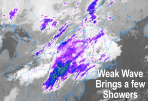
Good morning folks, we’ve got a weak wave moving into northern New England with some clouds and even a few showers in our northern zones which is followed by patchy frost overnight in some spots and then increasingly fair and warm conditions Tuesday into Thursday before a powerful front siphons abundant moisture into New England with rain and wind with a nice Fall weekend thereafter, but before we jump into the details, let’s check a note from our local and delicious sponsor, #TandemBagelCo, with their newest location in West Springfield, MA.
——————–
A NOTE FROM OUR SPONSOR:
DHTWN Is Sponsored by Members, Patrons & Tandem Bagel Company: No matter the weather, Tandem Bagel is always there for you at several valley locations to make your mornings brighter! With bagels baked fresh daily, house-whipped cream cheese, coffee, and tons of lunch options, Tandem is the perfect quick stop for lunch, breakfast, or a coffee and bagel to go. Find them in Easthampton, Northampton, Hadley, Florence, and West Springfield, or use their super-streamlined online ordering tool by visiting their website: https://www.tandembagelco.com
——————————————-
***DHTWN DAILY WEATHER REPORT***
——————————————-
NWS ALERTS
–None
DHTWN REMINDER
–The odds of being a human is 1 in 400,000 billion… make it count, even in a small way (see Kurt Vonnegut quote at end of post)
DAILY CELESTIAL (STAR):
–OUR STAR ROSE AT: 6:57am this morning
–OUR STAR WILL SET AT: 6:16pm this evening
–TOTAL DAYLIGHT TIME: 11 hours and 19 minutes
DAILY CELESTIAL (MOON):
–OUR MOON WILL RISE AT: 6:50pm this evening
–OUR MOON WILL SET AT: 8:46am tomorrow morning
–MOON RISE DIRECTION: East-Northeast
–MOON SET DIRECTION: West-Northwest
–MOON PHASE: Waning Gibbous (99.6%)
———————-
DAILY TERRESTRIAL (ZoneCast)
ZONE 1 (Northern Region)
Southern VT, Southwest NH, N. Taconics NY
–High Temps: Mid 50s to Low 60s
–Low Temps: Mid to Upper 30s
–Humidity: Comfortable
–Wind: Light westerly
–Skies: Mostly Cloudy
–Precipitation: A few showers possible today
ZONE 2 (Central Region)
WMass, N. CMass, N. Litchfield County, C./S. Taconics NY
–High Temps: Upper 50s to Mid 60s
–Low Temps: Mid 30s to Low 40s
–Humidity: Comfortable
–Wind: Light westerly, some gusts over 15mph southern areas
–Skies: Mostly Cloudy, some breaks of sun late in the day possible
–Precipitation: A few showers possible today, especially northern areas
ZONE 3 (Southern Region)
S. CMass, S. Litchfield County, NC.CT, & NE.CT
–High Temps: Low to Mid 60s
–Low Temps: Low to Mid 40s
–Humidity: Comfortable
–Wind: Westerly gusts up to 20mph possible
–Skies: Mostly Cloudy early, then partly sunny later afternoon
–Precipitation: An isolated sprinkle or two possible
———————-
WEATHER REPORT
Good morning everybody, we’re waking up to a mostly cloudy day with temps mostly in the 40s with some upper 30s sprinkled in, but no fog observed that I can see.
The weak wave I mentioned yesterday has a little bit more oomph this morning, but is still expected to be on the weak side and track into northern New England, bringing a few scattered showers to areas north of the Pike today, and especially along and north of the Rt. 2 corridor in MA, VT and NH.
While it looks like it will be mostly cloudy much of the day, we could see some partly sunny skies or at least some sunny breaks in southern MA and especially northern CT later this afternoon as this wave moves into and passes our longitude.
Highs will mostly be in the upper 50s to mid 60s for many of our towns in the region and winds may gust 10-20mph out of the west, especially the further south you go. Lows tonight as we clear things out will drop into the mid to upper 30s.
However, we can’t rule out a few low 30s readings if we clear our skies quickly enough, and so some patchy frost is possible in Franklin County, northern Worcester County and points west and north.
For Tuesday and Wednesday, absolutely gorgeousness abounds, and we really have to soak these days up as we head into the middle of October, because they are fleeting at this point, or soon will be.
Highs on Tuesday will reach the low to mid 60s under high-pressure-produced sunshine and lows will dip into the low 40s.
Highs on Wednesday will be even warmer, climbing into the 65-70º range under sunny skies (with lows in the 50s), so the next two days after today are looking super sweet!
However, once we reach Thursday clouds are going to be increasing, and we’re going to be watching a dynamic storm system crank up well west of us, and siphon abundant Gulf of Mexico moisture right up the eastern seaboard and hurl it into New England as a powerful jet aloft will be evacuating air away at the upper levels, creating a strong field of rising air across the region.
This will aid and abet a widespread area of showers, with downpours and some thunderstorms, to develop ahead and east of a cold front that passes through by Friday morning.
Highs will be mild on Thursday, reaching the mid to upper 60s, but clouds will be increasing early in the day, and we could see showers by noon.
The afternoon and overnight period looks rainy for sure, and still has the potential for some wind, but that will have to be refined and updated later.
Thursday night looks very rainy, and some street flooding is possible, with lows in the upper 40s to low 50s.
Any early morning Friday showers will give way to clearing skies and increasing sunshine with highs in the low 60s, and lows in the upper 30s under clear skies.
The weekend looks gorgeous with sunshine and highs in the upper 50s to mid 60s as high pressure builds in, but it looks like another dynamic system will arrive by early next week (possibly Tuesday), and another after that, so our pattern and wave length between systems may be changing and shortening, so stay tuned for updates.
Have a great day, and please check out my 2023 calendar, it’s a great local-color-filled daily companion, you’ll learn a bunch of cool local weather history, and it’s great for holiday gifts too!
SECURE 2023 CALENDAR ORDER/INFO LINK
Did you know that you can also follow me on Twitter?
AND REMEMBER…
“Hello babies. Welcome to Earth. It’s hot in the summer and cold in the winter. It’s round and wet and crowded. On the outside, babies, you’ve got a hundred years here. There’s only one rule that I know of, babies: Goddamn it, you’ve got to be kind.”
–Kurt Vonnegut