
Good morning everybody, we’ve got a few showers rolling through with a weak wave that trailed the cold front. Sunshine will develop with cool temps today and tomorrow, and then we’ll undergo a mildening early to mid next week with more sunshine prior to the potential for a dynamic frontal passage late week, but before we dive into all of the weather details below, let’s check a note from our local weekend sponsor, #YankeeMattressFactory, with their main headquarters in Agawam, MA along with stores located around the valley.
——————–
A NOTE FROM OUR WEEKEND SPONSOR:
DHTWN is sponsored by members, patrons, and Yankee Mattress Factory. Yankee Mattress is employee-owned, and mattresses are handmade locally in Agawam, MA. Several years ago I purchased a Yankee mattress and was very pleased with their quality and the buying experience, which was friendly and low pressure. Starting on September 1st and running through October 31st, Yankee Mattress will be partnering with the American Cancer Society to raise money to support breast cancer research and local services. A portion of each mattress sale will go towards their goal of donating $10,000 towards this cause. Visit the Yankee Mattress store closest to you in Agawam, Springfield, Northampton, or Greenfield, or click for more info.
——————————————-
***DHTWN DAILY WEATHER REPORT***
——————————————-
Good morning everybody, well last night was certainly lovely and celestial, what with the almost-full Moon Hunter’s Moon with big ol’ Jupiter sitting to the left of it as a much cooler, Canadian air mass advected into the region on blustery northwesterlies – I love this time of year!
We have a little wave this morning that has brought some light showers to the region, but that is exiting east with haste.
Temps are mostly in the 40s with some mid to upper 30s in SVT.
For today, sunshine will develop and winds will continue to gust out of the northwest up to 20mph, especially first half of the day, with highs reaching the low to mid 50s, with some upper 50s possible down in northern CT east of CT’s northwestern high terrain.
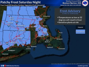
For tonight, winds should become westerly and be lighter, which is the key to the widespread Frost Advisory issuance by the NWS. We know it will be clear and dry, but as long as the wind sits down as expected, we should see widespread lows in the low to mid 30s, leading to areas of frost around the region, so protect what needs protecting, people.
For Sunday, we’ll enjoy the influence of massive high pressure, which will produce tons of sunshine and highs in the upper 50s to low 60s with westerly wind gusts up to 20mph at times. Lows will dip into the upper 30s to low 40s under partly cloudy skies.
Monday through Wednesday will feature our first episode of The Mildening, with plenty of sunshine throughout and Monday highs either side of 60º, Tuesday highs in the low to mid 60s, and Wednesday highs in the mid to upper 60s!
Lows will dip down to either side of 40º Monday and Tuesday nights, with lows in the mid to upper 40s Wednesday night.
By Thursday, however, some strong weather may be developing to our west as a strong cold front attached to a deepening winter storm over the northern Great Lakes approaches our region.
Thursday looks quite mild with highs in the 65-70º range with winds gusting from the south over 20mph, and partly sunny skies with clouds increasing by afternoon.
Then we’ll have to keep tabs over the coming days as to how this potential strong cold frontal passage and orientation of all features involved might impact the WMass region.
While it may end up being a showery and breezy frontal passage with another cool shot of air behind it, the sort of sweeping east-northeast potential track and the energy involved could produce severe weather in our region, so hopefully that does not come to pass, but do stay tuned!
Behind that system, the next weekend looks much cooler, as does the entire period from next weekend into the following weekend according to the CPC, so it appears that Autumn is continuing to deepen early this year.
Thanks for reading, and if you need holiday gifts or a calendar, I can say with humble confidence that this year’s edition is chock full of interesting LOCAL and historical weather event info, weather education, beautiful high-quality regional photos from local photographers, and so much more, so please visit my website for more details or to order by clicking here.
Thank you, and have a great day!
Remember that you can also follow me on Twitter.
AND REMEMBER…
“Hello babies. Welcome to Earth. It’s hot in the summer and cold in the winter. It’s round and wet and crowded. On the outside, babies, you’ve got a hundred years here. There’s only one rule that I know of, babies: Goddamn it, you’ve got to be kind.”
–Kurt Vonnegut