
Good morning everybody, we’ve got a pretty gray day ahead with rain at times for folks in southern areas, less rain north, breezy conditions for Sunday, and mostly fair and seasonable Autumn weather next week with a few showers possible around Tuesday, but before we dive into all of the weather details below, let’s check a note from our local weekend sponsor, #YankeeMattressFactory, with their main headquarters in Agawam, MA along with stores located around the valley.
——————–
A NOTE FROM OUR WEEKEND SPONSOR:
DHTWN is sponsored by members, patrons, and Yankee Mattress Factory. Yankee Mattress is employee-owned, and mattresses are handmade locally in Agawam, MA. Several years ago I purchased a Yankee mattress and was very pleased with their quality and the buying experience, which was friendly and low pressure. Starting on September 1st and running through October 31st, Yankee Mattress will be partnering with the American Cancer Society to raise money to support breast cancer research and local services. A portion of each mattress sale will go towards their goal of donating $10,000 towards this cause. Visit the Yankee Mattress store closest to you in Agawam, Springfield, Northampton, or Greenfield, or click for more info.
——————————————-
***DHTWN DAILY WEATHER REPORT***
——————————————-
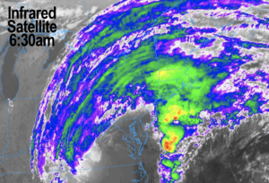
Good morning everybody, compared to other regions in eastern North America, and despite our drought (which has seen recent improvements according to the U.S. Drought Monitor) our western MA regional weather continues to be fairly benign in the aggregate.
That will continue for the next 7 days, though we’ll have a couple of showery bouts with which to contend, and today is the most substantial of them.
Before we do a double–dashed detailed dive into today’s weather story, a brief reminder that your orders of my 9th annual Weather Wall Calendar help support my work here.
Without any B.S. whatsoever, I can say this year’s edition is filled to the brim with great LOCAL and historical weather event info, weather education, gorgeous regional photos, and so much more, so please visit my website for more details or to order at this link.
Thank you for that, and now on with the show… I mean, report!
–The remnants of Ian’s cloud deck are streaming northward as the storm becomes a cold core system
–At the same time, we have high pressure squeezing southward into southern New England
–The two different pressure systems are meeting up over the great WMass region, moist air from the south, dry air from the north #SqueezePlay
–With some recent light pressure rises in our area, it appears that the best chance for steadier rain or periods of showers will set up south of the Pike in a west-southwest to east-northeast orientation
–This means in central MA that this shower shield could lift further north into central Worcester County vs. in Berkshire County or the Pioneer Valley where steadier showers should stay south of Pittsfield/Northampton/Amherst/Ware
–This is not to say areas north of the Pike won’t get some showers, we should see some there but lighter and more spotty, with little to none in SVT or SWNH (especially the northern halves of those areas)
–Drier air will work north to south into the region later this afternoon and tonight
–Highs will only be in the mid to upper 50s today with any showers weakening and abating by tonight with lows in the upper 40s
–For Sunday, drier air shunts showers south of us, but a stronger pressure gradient will produce northeast wind gusts of 20-30mph at times, with slightly higher gusts possible in northeast CT or the high peaks
–Highs will top out in the mid to upper 50s under mostly cloudy skies, though northern MA into SVT and SWNH may turn partly sunny
–Lows dip into the mid to upper 30s with patchy frost as wind slackens
–While a few showers are possible by Tuesday, we’re looking at mostly dry weather through all of next week, with seasonable temperatures
–We’ll be on the cool side in the upper 50s to low 60s Monday with lows in the upper 30s, but Tuesday through Thursday should see more of a 60s for highs / 40s for lows setup with partly to mostly sunny skies
–By late week into early next weekend we may see a cold frontal boundary bring some showers and cooler temps, and I will keep you updated on that as we get closer
Have a great day, and please check out my 2023 calendar, it’s a great local daily companion, and is great for holiday gifts too!
Remember that you can also follow me on Twitter.
AND REMEMBER…
“Hello babies. Welcome to Earth. It’s hot in the summer and cold in the winter. It’s round and wet and crowded. On the outside, babies, you’ve got a hundred years here. There’s only one rule that I know of, babies: Goddamn it, you’ve got to be kind.”
–Kurt Vonnegut