
Good morning folks, we’ve got some patchy fog in a few spots again this morning, but it looks pretty shallow. We’ve got a few SVT showers this morning and can’t rule out a spot shower anywhere today, with the main story through the weekend being the proliferation of peaceful weather conditions, but before we jump into the details, let’s check a note from our local and delicious sponsor, #TandemBagelCo, with their newest location in West Springfield, MA.
——————–
A NOTE FROM OUR SPONSOR:
DHTWN Is Sponsored by Members, Patrons & Tandem Bagel Company: No matter the weather, Tandem Bagel is always there for you at several valley locations to make your mornings brighter! With bagels baked fresh daily, house-whipped cream cheese, coffee, and tons of lunch options, Tandem is the perfect quick stop for lunch, breakfast, or a coffee and bagel to go. Find them in Easthampton, Northampton, Hadley, Florence, and West Springfield, or use their super-streamlined online ordering tool by visiting their website: https://www.tandembagelco.com
——————————————-
***DHTWN DAILY WEATHER REPORT***
——————————————-
NWS ALERTS
–None
DHTWN REMINDER
–The odds of being a human is 1 in 400 trillion… make it count, even in a small way (see Kurt Vonnegut quote at end of post)
DAILY CELESTIAL (STAR):
–OUR STAR ROSE AT: 6:44am this morning
–OUR STAR WILL SET AT: 6:37pm this evening
–TOTAL DAYLIGHT TIME: 11 hours and 53 minutes
DAILY CELESTIAL (MOON):
–OUR MOON WILL SET AT: 8:04pm this evening
–OUR MOON WILL RISE AT: 10:50am tomorrow morning
–MOON SET DIRECTION: West-Southwest
–MOON RISE DIRECTION: East-Southeast
–MOON PHASE: Waxing Crescent (7.1%)
———————-
DAILY TERRESTRIAL (ZoneCast)
ZONE 1 (Northern Region)
Southern VT, Southwest NH, N. Taconics NY
–High Temps: Low to Mid 60s
–Low Temps: Low to Mid 40s
–Humidity: Low
–Wind: Light Northwest
–Skies: Mostly cloudy to partly sunny at times
–Precipitation: Spot shower possible
ZONE 2 (Central Region)
WMass, N. CMass, N. Litchfield County, C./S. Taconics NY
–High Temps: Mid to Upper 60s
–Low Temps: Mid to Upper 40s
–Humidity: Low
–Wind: Light Northwest
–Skies: Partly sunny to Mostly Sunny
–Precipitation: Spot shower possible, especially west of I-91
ZONE 3 (Southern Region)
S. CMass, S. Litchfield County, NC.CT, & NE.CT
–High Temps: Mid to Upper 60s
–Low Temps: Upper 40s to Low 50s
–Humidity: Low
–Wind: Light Northwest
–Skies: Partly sunny to Mostly Sunny
–Precipitation: Spot shower possible, especially west of I-91
———————-
WEATHER REPORT
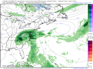
Good morning everybody, I hope you slept well and had good dreams. We’ve got lots of calm weather straight ahead, though the same can’t be said for much of the state of Florida today as Hurricane Ian slowly rakes the Fort Meyers / Port Charlotte area up to Orlando with heavy wind and rain.
For us in the greater WMass region, it’s possible we don’t see any impacts from Ian, as in not even a rain drop, but if we do, it would along around Saturday night into Sunday, and south of the Pike, at this point.
The double–dashes will detail the points of saliency below:
–A lazy, lollygagging upper trough continues to sit and spin and slowly die out over the eastern Great Lakes today
–This has already sent some light showers into southern VT overnight as well as the northern Berkshires where a few spots picked up closed to two-tenths of an inch of rainfall
–For today, that system slowly presses east with its cold front, and should produce a partly sunny day on average, with a few spot showers possible, especially in the western hilltowns, Berkshires, Taconics, SVT areas
–Highs will reach the low to upper 60s with lighter winds, and lows in the 40s
–For Thursday, highs will dip a little behind the cold front, only reaching the upper 50s to mid 60s under mostly sunny skies with some fair weather afternoon clouds
–Thursday night looks clear, calm, and dry, which will maximize radiational cooling and promote patchy frost development
–Lows will drop into the mid to upper 30s
–Friday will be mostly sunny thanks to incoming high pressure (the first of two powerful high pressure cells to include our weather into next week)
–Highs will reach the low to mid 60s with lows in the 40s under partly cloudy skies
HURRICANE IAN REMNANTS STAY SOUTH
–A couple of high pressure areas will dominate our weather through the weekend
–As Ian runs northeast through FL, emerges off the coast, then wanders north into Georgia and the western Carolinas
–As it does so, it’ll hit a big zonally-oriented high pressure cell north of it
–This will shear and stretch out the rain shield and weaken Ian’s remnant low center
–This means that much of the rain shield will be shunted south of us, as a second high pressure dives southeast out of Canada by early next week to give it the knock out blow
–We will still see clouds from Ian’s remnants, so expect this weekend now to be partly sunny trending to mostly cloudy as we move through that pair of days
–Highs in the 60s and lows in the 40s are expected both days/nights, and a few showers are possible south of the Pike late Saturday night into early Sunday, but even those chances may dry up, we’ll see
–By early next week we’ll cool down as whatever energy left of Ian is shipped east and out to sea as Canadian high pressure moves in
–This will keep our temps cool with highs in the upper 50s to low 60s and lows in the upper 30s to low 40s with more showers possible by mid week
–One thing is for sure, we have very little in the way of rainfall coming through the next 7 days, so the drought continues
Have a great day!
Did you know that you can also follow me on Twitter?
AND REMEMBER…
“Hello babies. Welcome to Earth. It’s hot in the summer and cold in the winter. It’s round and wet and crowded. On the outside, babies, you’ve got a hundred years here. There’s only one rule that I know of, babies: Goddamn it, you’ve got to be kind.”
–Kurt Vonnegut