
Good morning folks, yet again we’ve got some patchy fog out there. In some cases, it’s just shallow fog wisping about, but in other spots like northern CT there are dense fog reports of a quarter to half mile visibility. You know the drill, take it slow in any fog patches, I believe in you!
Generally speaking, we’ll see a cold front move through today with isolated to scattered showers, downpours and storms, and we can’t rule out a small squall line forming somewhere in WMass.
After that activity works through by this evening, we’ll dry things out for Wednesday through Friday noon prior to another fairly weak cold front bringing a few showers or storms.
Our weekend will follow with drier conditions and sunshine lasting into early next week when heat and humidity will return, along with more showers possible by Tuesday with the potential for dry and cool Canadian air to flush this late-Summer soup down the drain thereafter, but before we dive into all of the weather details below, let’s check a note from our local and delicious sponsor, #TandemBagelCo, with their newest location in West Springfield, MA.
——————–
A NOTE FROM OUR SPONSOR:
DHTWN Is Sponsored by Members, Patrons & Tandem Bagel Company: No matter the weather, Tandem Bagel is always there for you at several valley locations to make your mornings brighter! With bagels baked fresh daily, house-whipped cream cheese, coffee, and tons of lunch options, Tandem is the perfect quick stop for lunch, breakfast, or a coffee and bagel to go. Find them in Easthampton, Northampton, Hadley, Florence (and now West Springfield!), or use their super-streamlined online ordering tool by visiting their website: https://www.tandembagelco.com
——————————————-
***DHTWN DAILY WEATHER REPORT***
——————————————-
NWS ALERTS
–None
DHTWN REMINDER
–The odds of being a human is 1 in 400 trillion… make it count, even in a small way (see Kurt Vonnegut quote at end of post)
DAILY CELESTIAL (STAR):
–OUR STAR ROSE AT: 6:06am this morning
–OUR STAR WILL SET AT: 7:38pm this evening
–TOTAL DAYLIGHT TIME: 13 hours and 32 minutes
DAILY CELESTIAL (MOON):
–OUR MOON WILL SET AT: 6:06pm this evening
–OUR MOON WILL RISE AT: 2:59am tomorrow morning
–MOON SET DIRECTION: Northwest
–MOON RISE DIRECTION: Northeast
–MOON PHASE: Waning Crescent 13.9%
———————-
DAILY TERRESTRIAL (ZoneCast)
ZONE 1 (Northern Region)
Southern VT, Southwest NH, N. Taconics NY
–High Temps: Mid to Upper 70s
–Low Temps: Low to Mid 60s
–Humidity: Dewpoints well into the 60s to near 70º, muggy
–Wind: Light southerly wind
–Skies: Mostly Cloudy with sunny breaks at times
–Precipitation: Scattered showers, downpours and t-storms, mostly in the afternoon and evening, quitting between 8pm-midnight
ZONE 2 (Central Region)
WMass, N. CMass, N. Litchfield County, C./S. Taconics NY
–High Temps: Upper 70s to Low 80s
–Low Temps: Low to Mid 60s
–Humidity: Dewpoints well into the 60s to near 70º, muggy
–Wind: Light southerly wind
–Skies: Mostly Cloudy with sunny breaks at times
–Precipitation: Scattered showers, downpours and t-storms, mostly in the afternoon and evening, quitting between 8pm-midnight
ZONE 3 (Southern Region)
S. CMass, S. Litchfield County, NC.CT, & NE.CT
–High Temps: Upper 70s to Low 80s
–Low Temps: Low to Mid 60s
–Humidity: Dewpoints well into the 60s to near 70º, muggy
–Wind: Light southerly wind
–Skies: Mostly Cloudy with sunny breaks at times
–Precipitation: Scattered showers, downpours and t-storms, mostly in the afternoon and evening, quitting between 8pm-midnight
———————-
WEATHER REPORT
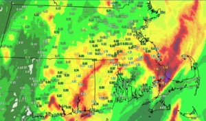
Good morning fellow humans, yesterday provided the best period of rain many of us have seen in many weeks, and while it’s not nearly enough to counteract the drought we’re experiencing, every bit does help.
As I had said, some folks would see little to no rain, and just such an area formed west of the I-91 corridor in southwest MA down into northwest CT, with other lighter areas in parts of the northern Berkshires into the Bennington area, and again in parts of northern MA.
However, Greenfield clocked in with over 2″ of rain, and Brattleboro saw over an inch of rain, with a number of areas seeing a quarter to three-quarters of an inch.
That activity is gone now, and with overall cyclonic flow across the region thanks to an upper low that will be drifting northeast and through northern New England today, we’ll likely see more clouds than sunshine across the span of today and this evening, and humidity will stay up, so expect a muggy feel.
Some isolated to scattered morning showers or even a weak t-storm may form later in parts of the WMass region through noon, but as the cold front approaches the region later this afternoon and in the early evening, that is when our best chance for some of us to see scattered showers and thunderstorms will be.
We can’t even rule out a small cluster or broken squall line capable of producing a strong thunderstorm with some gusty winds over 30mph, but severe weather is not expected.
If we end up more on the mostly cloudy side, that may help to keep surface instability better in check, which could inhibit much in the way of thunderstorm growth, but I will update on this around mid day.
Highs will reach the mid 70s to low 80s, and any activity wanes after 7 or 8pm tonight with lows in the low to mid 60s.
———————
LAST CALL TO WMASS REGIONAL PHOTOGRAPHERS FOR MY 2023 WEATHER WALL CALENDAR…My friend, if you’ve submitted in past years, or fancy yourself a fine photographer of the greater WMass region’s natural beauty (WMass, CMass, S.VT, SW.NH, or northern CT), please click the secure link to my website below to get the details on how you can be seen by over 1000 of your neighbors and be included in my 9th consecutive (and likely last) local/regional weather wall calendar.
The deadline for submission is 9/3/2022, and I really hope you’ll send some photos for consideration!
CLICK SECURE LINK!
———————
For Wednesday through Friday mid day, we’ve got fair weather on the way, with a bit drier conditions in terms of humidity thanks to incoming high pressure to our west.
Highs will rise well into the 80s during this period, and while Wednesday may start off on the partly sunny side, Thursday looks like the pick of the week in terms of dry and sunny conditions (maybe rainy days are the new “pick of the week”?!).
Lows will sit in the upper 50s to low 60s during this period, in general.
By Friday afternoon and evening, a weak disturbance will bring a tepid cold front through along with some scattered showers or storms being possible, but should not be a big deal.
The weekend looks lovely with mostly sunny skies, drier air, and highs in the low to mid 80s and with lows in the upper 50s to low 60s with lighter winds.
Early next week may feature a warm up along with a humidity increase in front of a stronger cold front that arrives by Tuesday or Wednesday.
This system could bring more showers and storms through, along with a cooler and drier change of air mass by later next week, so stay tuned for updates on that as we head into the month of September with sub-7:30pm sunsets.
It’s happening, people – that slow shift and gear up to accept the transition out of Summah as we don our New England-y expertise in and experience with season shifting, given that next week will be welcoming the beginning of Meteorological Autumn, which hopefully will bring much needed pattern shifting and rainfall to the region.
That does it for now, my friends, I hope you have a great day!
Did you know that you can also follow me on Twitter?
AND REMEMBER…
“Hello babies. Welcome to Earth. It’s hot in the summer and cold in the winter. It’s round and wet and crowded. On the outside, babies, you’ve got a hundred years here. There’s only one rule that I know of, babies: Goddamn it, you’ve got to be kind.”
–Kurt Vonnegut