
Good morning folks, we’re starting out with a mix of sun and clouds along with patchy dense fog in spots. Temps are in the 50s and 60s, as are dew points and we have low pressure skirting the southern New England coast.
We have some shower chances today in some areas, to be followed by a marked drop in humidity and fair weather through the weekend prior to a growing potential for an atypical pattern setting up next week that may deliver some much-needed rainfall, but before we dive into all of the weather details below, let’s check a note from our local and delicious sponsor, #TandemBagelCo, with their newest location in West Springfield, MA.
——————–
A NOTE FROM OUR SPONSOR:
DHTWN Is Sponsored by Members, Patrons & Tandem Bagel Company: No matter the weather, Tandem Bagel is always there for you at several valley locations to make your mornings brighter! With bagels baked fresh daily, house-whipped cream cheese, coffee, and tons of lunch options, Tandem is the perfect quick stop for lunch, breakfast, or a coffee and bagel to go. Find them in Easthampton, Northampton, Hadley, Florence (and now West Springfield!), or use their super-streamlined online ordering tool by visiting their website: https://www.tandembagelco.com
——————————————-
***DHTWN DAILY WEATHER REPORT***
——————————————-
NWS ALERTS
–None
DHTWN REMINDER
–The odds of being a human is 1 in 400 trillion… make it count, even in a small way (see Kurt Vonnegut quote at end of post)
DAILY CELESTIAL (STAR):
–OUR STAR ROSE AT: 5:53am this morning
–OUR STAR WILL SET AT: 7:56pm this evening
–TOTAL DAYLIGHT TIME: 14 hours and 3 minutes
DAILY CELESTIAL (MOON):
–OUR MOON WILL RISE AT: 8:16pm this evening
–OUR MOON WILL SET AT: 6:12am tomorrow morning
–MOON RISE DIRECTION: East-Southeast
–MOON SET DIRECTION: West-Southwest
–MOON PHASE: Full Sturgeon Moon
–METEORS: Perseid Meteor Shower is peaking through late week
———————-
DAILY TERRESTRIAL (ZoneCast)
ZONE 1 (Northern Region)
Southern VT, Southwest NH, N. Taconics NY
–High Temps: Low to Mid 80s
–Low Temps: Mid to Upper 50s
–Humidity: Dewpoints in the 50s to low 60s, crashing into the 40s and 50s by tomorrow morning
–Wind: Calm to Light Variable Wind
–Skies: Mixed sun and clouds
–Precipitation: Isolated shower or thunderstorm later this afternoon or early evening w/ cold frontal passage
ZONE 2 (Central Region)
WMass, N. CMass, N. Litchfield County, C./S. Taconics NY
–High Temps: Low to Mid 80s
–Low Temps: Mid 50s to Low 60s
–Humidity: Dewpoints in the 50s to low 60s, crashing into the 40s and 50s by tomorrow morning
–Wind: Calm to Light Variable Wind
–Skies: Mixed sun and clouds, more clouds south
–Precipitation: Isolated shower or thunderstorm later this afternoon or early evening w/ cold frontal passage
ZONE 3 (Southern Region)
S. CMass, S. Litchfield County, NC.CT, & NE.CT
–High Temps: Low to Mid 80s
–Low Temps: Low to Mid 60s
–Humidity: Dewpoints in the 60s, crashing into the 40s and 50s by tomorrow morning
–Wind: Calm to Light Variable Wind
–Skies: Mostly Cloudy
–Precipitation: A period of light showers moves through northeastern CT and southeast CMass mid to late morning, then isolated shower or t-storm possible late afternoon into the evening
———————-
WEATHER REPORT
Good morning everybody, one thing I’ve found as I age is that life can really be slog sometimes. Knowing that it’s not going to end well for any of us is a bit dispiriting, but then I remember that we’re lucky to even have some human experiences in the first place.
The great times feel great, and the painful ones remind us of how great the great ones are, and sometimes can deepen us and help us grow, if we’re fortunate and can maybe see it from that perspective.
A bit contemplative out of the gate, true, but that’s where I’m at this morning… and now here’s Dave with the weather!
I don’t think that our heat and humidity surges are gone for this season, but the pattern appears to be buckling for now.
Given the fact that we’re looking at a potential atypical winter setup in mid-August for next week is impressive and illustrative of the “what goes up must come down” energy balancing that often takes place with the weather.
In the short run we have a mix of sun and clouds for today, thanks in part to a low pressure center near New Jersey, which will track east, and spread clouds and some showers into parts of north-central and northeast CT, possibly up into southernmost parts of Worcester County, into RI and EMass this morning.
By noon or so, that fleeting rain shield will be out of here, and we’ll see some more sunny breaks develop. However, a second cold front will be pressing into the region this evening and overnight.
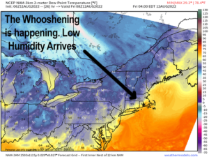
Highs today will reach the low to mid 80s with moderate humidity and light wind, and then we can expect some widely scattered showers or a thunderstorm to move in late afternoon and evening with the cold front. Lows will drop into the 50s in WMass/CMass and points north, with low to mid 60s over northern CT as we dry out and low humidity air whooshes in!
#WHOOOOOOOOOOSSSSHHHHHHHHHHH!
Friday through Sunday will be dominated by incoming Canadian high pressure located to our northwest and north, and that northerly component to the flow will cool us down into the mid 70s to low 80s for highs Friday and Saturday under mostly sunny skies with lows in the low to mid 50s.
Perfection, if you ask me!
Sunday is a touch warmer, with sunny skies and highs in the upper 70s to mid 80s with lows in the mid to upper 50s.
By Monday, we are going to be monitoring to see how a winter-type setup evolves.
As of now, it appears that high pressure will flex to our north in eastern Canada, while an upper level trough develops in the northeast U.S. in response to a building ridge in the western U.S., which is connected to an upper trough near the Aleutian Islands and Alaska.
As some disturbances drop southeast into the upper trough near the Great Lakes and northern Ohio Valley, we may see a cooler, more unsettled pattern develop that could spawn some coastal storminess of capable of bringing periods of rain to the greater WMass region.
I am hyper-aware of the drought we’re in, and how much we need the rain, so I don’t want to over-promise on rain being a definite thing this far out – it’s not.
But this pattern is evolving into a favorable setup for periods of rainfall from Monday afternoon into Wednesday afternoon, so please stay tuned for further updates.
High temperatures would likely only rise to the low to mid 70s with lows near 50º during this period, so it’s safe to say that for now, we’ve broken the heat through next week.
After that, we may see some resurgence. I mean, it’s only mid-August, but this winter-type upper level pattern may be telling us that a slow descent toward Autumn could have been initiated.
Time will tell, and remember… don’t sleep on the peak of the Perseid Meteor Shower tonight and tomorrow night (info link below)!
It won’t be ideal viewing given the Full Sturgeon Moon tonight (please post pics later!), but you should still get some good sightings in, maybe around 4am-5am before sunrise tomorrow, given that some clouds may linger earlier tonight with our cold front moving through.
Have a great day, and please follow me on Twitter if you’re there…
AND REMEMBER…
“Hello babies. Welcome to Earth. It’s hot in the summer and cold in the winter. It’s round and wet and crowded. On the outside, babies, you’ve got a hundred years here. There’s only one rule that I know of, babies: Goddamn it, you’ve got to be kind.”
–Kurt Vonnegut