
Good morning folks, we’ve got some patchy fog and low clouds early this morning with temps in the 60s and low 70s and dewpoints in the 60s, but sunshine will develop as the morning wears on. Aside from a very hot Thursday with heat indices over 100º in spots, we’ve got fairly standard summer weather on the way into early next week with chances for isolated to scattered afternoon showers and thunderstorms for most of the next 7 days, with best chance for downpours and heavier rain coverage coming on Friday afternoon, but before we dive into all of the weather details below, let’s check a note from our local and delicious sponsor, #TandemBagelCo, with their newest location in West Springfield, MA.
——————–
A NOTE FROM OUR SPONSOR:
DHTWN Is Sponsored by Members, Patrons & Tandem Bagel Company: No matter the weather, Tandem Bagel is always there for you at several valley locations to make your mornings brighter! With bagels baked fresh daily, house-whipped cream cheese, coffee, and tons of lunch options, Tandem is the perfect quick stop for lunch, breakfast, or a coffee and bagel to go. Find them in Easthampton, Northampton, Hadley, Florence (and now West Springfield!), or use their super-streamlined online ordering tool by visiting their website: https://www.tandembagelco.com
——————————————-
***DHTWN DAILY WEATHER REPORT***
——————————————-
NWS ALERTS
–None
DHTWN REMINDER
–The odds of being a human is 1 in 400 trillion… make it count, even in a small way (see Kurt Vonnegut quote at end of post)
DAILY CELESTIAL (STAR):
–OUR STAR ROSE AT: 5:44am this morning
–OUR STAR WILL SET AT: 8:07pm this evening
–TOTAL DAYLIGHT TIME: 14 hours and 23 minutes
DAILY CELESTIAL (MOON):
–OUR MOON WILL SET AT: 10:44pm tonight
–OUR MOON WILL RISE AT: 11:34am tomorrow morning
–MOON SET DIRECTION: West
–MOON RISE DIRECTION: East
–MOON PHASE: Waxing Crescent 20.4%
———————-
DAILY TERRESTRIAL (ZoneCast)
ZONE 1 (Northern Region)
Southern VT, Southwest NH, N. Taconics NY
–High Temps: Low to Mid 80s
–Low Temps: Upper 50s to Low 60s
–Humidity: Humid, dewpoints well into the 60s
–Wind: Light southwesterly
–Skies: Mostly sunny after low clouds/fog burn off
–Precipitation: Isolated afternoon showers or thunderstorms
ZONE 2 (Central Region)
WMass, N. CMass, N. Litchfield County, C./S. Taconics NY
–High Temps: Mid 80s to Low 90s
–Low Temps: Upper 50s to Mid 60s
–Humidity: Humid, dewpoints well into the 60s
–Wind: Light southwesterly
–Skies: Mostly sunny after low clouds/fog burn off
–Precipitation: Isolated afternoon showers or thunderstorms
ZONE 3 (Southern Region)
S. CMass, S. Litchfield County, NC.CT, & NE.CT
–High Temps: Upper 80s to Low 90s
–Low Temps: Low to Mid 60s
–Humidity: Humid, dewpoints well into the 60s
–Wind: Light southwesterly
–Skies: Mostly sunny after low clouds/fog burn off
–Precipitation: Isolated afternoon showers or thunderstorms
———————-
WEATHER REPORT
Good morning everybody, we’ve got a peaceful start to the day with humidity up, clouds in for some, and patchy fog in spots. The morning will remember who’s boss soon enough, and our star will help to evaporate any fog or low cloudiness which will reveal a mostly sunny day with some higher clouds working overhead.
Highs will reach the low to upper 80s, and a few spots could touch 90º or 91º. In addition, given the strong surface heating, some forcing (i.e. the mechanical lifting of air parcels) from a cold front moving into the region, and humidity ahead of it, some showers or non-severe thunderstorms should pop in a widely scattered pattern / presentation by later afternoon and early evening, and one or two storms may become strong.
Everything flares down tonight with lows in the upper 50s to mid 60s as humidity tamps down behind the front as well.
For Wednesday, a super sweet day arrives with lower humidity (for a day) and highs climb into the low to upper 80s under sunny skies. Lows will sit down in the mid 60s, but humidity will be on the increase into Thursday which looks quite hot and humid.
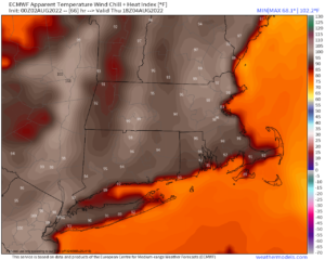
Heat Advisories will likely need to be hoisted by the NWS for Thursday if trends continue, as highs should reach the mid to upper 90s, with low 90s up in the high terrain of SVT and SWNH and far northwest MA. Dew points will be in the upper 60s to mid 70s, so it’ll be a day to put some extra focus on hydration and keeping cool, especially for those with respiratory issues or other relevant medical issues.
Lows Thursday night will only dip into the upper 60s to low 70s, and a few isolated showers or thunderstorms may pop in the later afternoon or evening.
For Friday, a cold front will be on the way, but wind shear doesn’t look super strong, so this looks to be more of a heavy rain threat with any thunderstorms that do form in the afternoon.
Highs will reach the 85-90º range, and scattered showers and thunderstorms should last into the evening with lows in the 60s.
The Saturday through Monday timeframe looks to feature quite standard southern New England summer weather with highs in the 85-90º range, muggy, and a chance each afternoon for isolated to scattered showers or thunderstorms, with most folks remaining dry, and lows in the 60s.
By the middle of next week we may see a front come through to amp up the shower and storm chances, but we’ll deal with that as it approaches.
Thanks for reading, have a great day, and please follow me on Twitter if you’re there…
AND REMEMBER…
“Hello babies. Welcome to Earth. It’s hot in the summer and cold in the winter. It’s round and wet and crowded. On the outside, babies, you’ve got a hundred years here. There’s only one rule that I know of, babies: Goddamn it, you’ve got to be kind.”
–Kurt Vonnegut