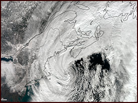
February 8-9, 2013
MY STORY
I remember realizing that the Blizzard of 2013 was going to form a couple days before it did. I had chills on the back of my neck as I saw all of the elements coming together perfectly. It takes a LOT of weather-based factors to align to produce such a truly perfect storm. You need a Miller A pattern to provide a large storm with copious amounts of warm, moist air and plenty of time to deepen and intensify over the warm Gulf Stream waters of the western Atlantic Ocean.
You also need a cold Arctic high pressure system in just the right place in eastern Canada to the north of New Hampshire and Maine to provide not only very cold air into New England, but also act as a blocking atmospheric element to slow the storm down a little. And you need a storm track just to the southeast of Cape Cod, along with no major weather elements in the Midwest that would otherwise push the storm out to sea. Periods of high coastal tides can also play into the severe negative impacts of these storms, as was the case with the Blizzard of ’78.
All of these elements came together in early February of 2013, and I knew ahead of time that we were looking at an historic, truly epic New England blizzard, and one for the record books. I remember that a steady light snow moved in during the afternoon, only dropping an inch of two of snow for the first several hours. It actually seemed like no big deal during the day.
I got home from work, and started to blog on my Facebook page and take hourly snow measurements. Very quickly, we started to see 1+ inch per hour snowfall rates as the night wore on. You can tell when a major snowstorm is on, when instead of huge, fat flakes, the air is FILLED with tons of smaller flakes. That is what occurred with this blizzard.
I was blogging furiously during the storm, taking in reports, and interacting as much as I could with everybody. I was starting to get very tired when around 11pm I noticed on radar a HUGE and heavy snow band begin to be thrown northwestward from around Plymouth County in Massachusetts. I have seen this MANY times, and usually these bands do not make it to Western Mass. They lose intensity, they die out entirely, they eventually crash southwest over CT and miss us, or any number of other things happen to keep us too far west from such heavy snow bands off the ocean. We are simply too far away from the coast normally to get into these ocean-enhanced bands of snow.
But this time was different. I could sense it.
I fought through my exhaustion to watch this band slowly, but surely, travel through Eastern Massachusetts, then Central Massachusetts, and then over Western Massachusetts. I could not believe that it held together! It was a snow lover’s dream, for sure.
When this band passed over our region, I have never seen it snow as hard during a two-hour period in my life. I measured, and it snowed NINE INCHES IN TWO HOURS!! I’ve been following the weather for over 30 years, and I’d never seen that before. Once that band passed over, and lost intensity, I decided it was time to face plant into my pillow, but I am so glad I stayed up to see that intensity of snow. We ended up with two feet of snow in Deerfield, and over 35% of that fell in two hours!!
NOAA Time Lapse Video – Blizzard of 2013 Satellite Loop
STORM FACTS
Lowest Barometric Pressure
968 millibars/28.6 inches
Highest Snowfall Recorded
40 inches, Hamden, CT
Highest Measured Land Wind Speed
89mph in Mt. Desert Rock, ME
Storm Surge
4.2 feet in Boston, MA

