[7:00AM THURS 4/25/24] DID ANYTHING FREEZE? *NEW* FREEZE WATCHES ARE UP FOR THE REGION AGAIN TONIGHT... HIGH PRESSURE BUILDS IN FROM THE NORTHWEST WITH 3 MOSTLY SUNNY DAYS ON THE WAY... COOLER TODAY, MILDER FRIDAY/SAT... CLOUDS INCREASE SAT. AFTERNOON WITH OVERNIGHT SHOWERS INTO EARLY SUNDAY MORNING, DRIER AFTERNOON... WARM ON MONDAY IN THE 70s FOLLOWED BY PERIODS OF UNSETTLED WEATHER POSSIBLE TUESDAY THROUGH THURSDAY....
FEATURED PAGE

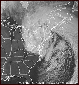
A Nor’easter is THE classic New England snowstorm. It has a classic comma shape when fully formed. There are times when Western Massachusetts can get the most snow when compared to all of southern New England from these storms. This requires that enough warm air be transported into the coastal plain, turning CT and RI and southeastern MA to ice and rain. However, if enough cold air is in place, the areas to the east and south of Western Massachusetts get the most snow from these storms, because they are closest to the storm track.
STORM TRIBUTES

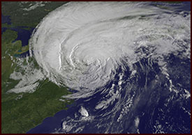
Hurricane Irene was literally a giant storm. At one point, it covered the entirety of the east coast. We got very lucky here in Western Massachusetts in terms of wind impacts. Because the storm hugged the coast, it caused the hurricane to be downgraded to a Tropical Storm before it reached our area. In addition, it passed over Western Massachusetts, putting us out of the way of the strongest winds, which are to the north and east of the low center. As I remember, Irene was downgraded to a Tropical Storm with sustained winds of 65mph by the time it crossed over New York City.