
Dave's Daily Report
June 10, 2026
7:26 am

WMASS HEAT ADVS

T STORM RISKS THURS FRI

thurs pm storms

thursday heat index
upper cool trofing
HEAT ADVISORIES HAVE BEEN HOISTED FOR WMASS AND NORTHERN CT THURSDAY AND FRIDAY… SCATTERED SHOWERS AND T-STORMS EACH AFTERNOON AND EVENING POSSIBLE… SOME STORMS MAY BECOME SEVERE
Good morning everybody, we’re moving into a very warm to hot and humid period in the greater WMass region, which will peak in intensity on Thursday and Friday, and consequently Heat Advisories have been hoisted for WMass and northern CT for BOTH days as heat indices (the combo of air and dewpoint temps, or “feels-like” or “apparent temperature”) reach to either side of 100º with high air temps pushing into the upper 80s to mid 90s each day. We’ve got increased thunderstorms chances as well, so let’s cannonball in, wheeeee!
For today, a warm front will be approaching the region. Ahead of that feature, dewpoints are in the 50s, but those will be increase later today, rising into the 60s which will make things feel muggier for sure.
Highs will reach the low to mid 80s under partly sunny skies, but as the warm front arrives later this evening, clouds will increase in the afternoon and some scattered showers, or even a downpour or t-storm are possible.
Dewpoints will climb tonight and as lows settle into the 60s, we can expect patchy fog to form overnight, along with a continued chance for a shower or thunderstorm.
The warm front clears the region to our north for the end of the week, so Thursday and Friday are looking hot and humid with highs in the upper 80s to mid 90s with heat indices pushing 100º both days with Thursday night lows in the mid 60s to low 70s.
This means that if you have pulmonary / respiratory issues or work outside, you gotta just be sure to stay hydrated, take breaks, move a bit more slowly, and overall just take care of yourself more.
In addition, instability will be increasing and we’ll see scattered showers and thunderstorms each afternoon and evening, and some may become strong to severe with higher wind gusts and small hail.
After Friday night lows in the 60s, our flow starts to turn more west to east into New England, which should help knock the humidity down a bit, but temps will still be very warm to hot with highs in the lows 80s to low 90s from the moutnains to the valley, and lows either side of 60º.
It is looking pretty dry this weekend, so for now expect partly to mostly sunny skies with a spot shower possible.
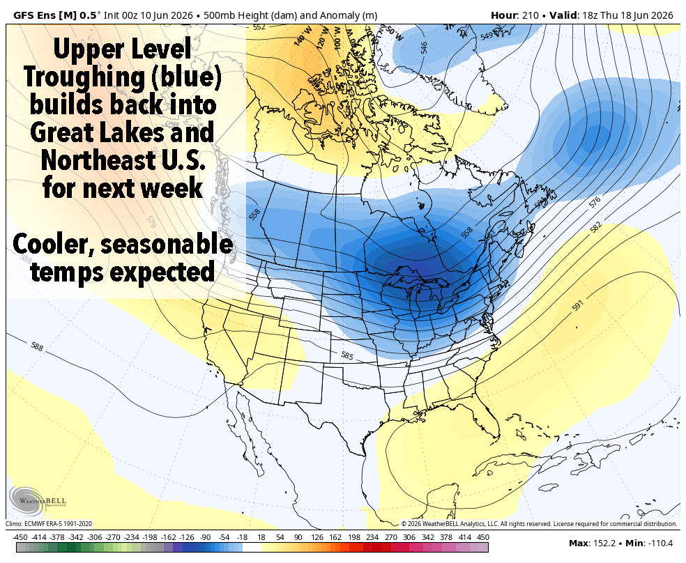
By early next week we’re moving back to more seasonable highs in the 70s to low 80s, but with that will come an increase in disturbances or fronts, and thus scattered shower potential, and we certainly need it!
Thanks for reading and I hope you have a great day!
“Follow your bliss and the universe will open doors for you where there were only walls.”
― Joseph Campbell
YOUR NUTSHELL:
–Partly sunny skies expected today with increasing humidity by later this afternoon
–Highs reach the low to mid 80s, with more clouds developing late
–A warm front pushes into the region late today and tonight with scattered showers, downpours or a thunderstorm possible
–Moisture is increasing, and so a few cells may produce heavy rain
–Lows tonight hang in the 60s with patchy fog developing as dewpoints continue to rise into the 60s to meet falling air temps
–For Thursday, we’re in the hot and humid air mass through Friday with Heat Advisories up both late-week days
–Highs reach the mid 80s to mid 90s from high terrain to valley floor both days, and it will be quite humid
–Scattered showers and thunderstorms expected each day, and strong to severe thunderstorms will be possible each afternoon, especially in the Berkshires and northwest CT
–Lows each night will hang in the 60s to near 70º, so it will be increasingly uncomfortable
–By the weekend, temps will range mostly in the mid 80s to low 90s as our flow turns more zonal (i.e. west to east) which will at least lower humidity a bit
–An isolated shower is possible, but we should be mostly dry
–A cold front slowly pushes into the region early next week with high temps coming down to more seasonable levels, mainly in the mid 70s to low 80s
–Scattered showers are possible early next week as well
YOUR DAILY CELESTIALS
STAR:
–OUR STAR ROSE AT: 5:14am this morning
–OUR STAR SETS AT: 8:25pm this evening
–TOTAL DAYLIGHT TIME: 15 hours and 11 minutes
MOON:
–OUR MOON SETS AT: 3:21pm this afternoon
–MOON SET DIRECTION: West-Northwest
–OUR MOON RISES AT: 2:12am tomorrow morning
–MOON RISE DIRECTION: East-Northeast
–MOON PHASE: Waning Crescent (28.6%)
A NOTE FROM OUR WEEKDAY SPONSOR
Gerard, Ghazey & Bates, P.C.
Dave Hayes The Weather Nut is Sponsored by Individual Community Members, Patrons, and Gerard, Ghazey & Bates, P.C.
GGBPC is a Northampton-based law firm and is the area’s premier estate and tax planning provider. The firm specializes in Estate Planning, Elder Law, and Tax Law, so be sure to contact GGBPC today to see how they can help you.
Simply click the following link to their secure website.