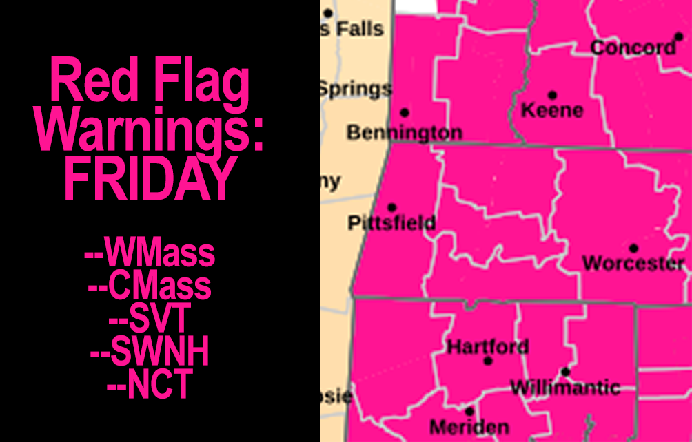
[7:12AM FRI 11/15/24] RED FLAG WARNINGS ARE UP TODAY FOR THE ENTIRE GREATER WMASS REGION… DON’T BURN STUFF OUTSIDE… NORTHWEST WIND GUST 15-25MPH AS THE DAY WEARS ON… ANY SUNRISE PICS? GORGEOUS WEEKEND AHEAD, MILDER, SUNNY… A FEW MONDAY MORNING SHOWERS, THEN FAIR WEATHER INTO MID-WEEK… POTENTIAL PATTERN CHANGE LATE WEEK WITH WET WEATHER IN THE CARDS AS UPPER LEVEL SETUPS TRADE PLACES ACROSS THE U.S… FULL BEAVER SUPERMOON TONIGHT…

If you missed the sale deadline Sunday night for my 2025 Calendar, you can still place last-minute orders for inclusion with my print run (click).
~~~~~~~~~~~~~~~~~~~~~~
TABLE OF CONTENTS
* Daily Celestials (Sun/Moon Data)
* Sponsor Note
* Morning Discussion
* TIP: Scroll below for sections, or read all
~~~~~~~~~~~~~~~~~~~~~~
YOUR DAILY CELESTIALS
~~~~~~~~~~~~~~~~~~~~~~
STAR:
–OUR STAR ROSE AT: 6:41am this morning
–OUR STAR WILL SET AT: 4:28pm this evening
–TOTAL DAYLIGHT TIME: 9 hours and 47 minutes
MOON:
–OUR MOON WILL RISE AT: 4:03pm this afternoon
–MOON RISE DIRECTION: East-Northeast
–OUR MOON WILL SET AT: 7:47am tomorrow morning
–MOON SET DIRECTION: Northwest
–MOON PHASE: Full Beaver Supermoon (99.7%)
~~~~~~~~~~~~~~~~~~~~~~
A NOTE FROM OUR SPONSOR
~~~~~~~~~~~~~~~~~~~~~~
Dave Hayes The Weather Nut is Sponsored by Individual Community Members, Patrons, and Tandem Bagel Company… No matter the weather, Tandem Bagel is always there for you at several valley locations to make your mornings brighter! With *New Pizza Bagels(!)*, along with bagels baked fresh daily (including Gluten-Free options), house-whipped cream cheese, coffee, and tons of lunch options, Tandem is the perfect quick stop for lunch, breakfast, or a coffee and bagel to go.
You can either 1) visit them in Easthampton, Northampton, Hadley, Florence, and/or West Springfield, 2) hire them to cater your next event, or 3) use their super-streamlined online ordering tool by visiting their website and clicking the “Catering” or “Order Online” links.
~~~~~~~~~~~~~~~~~~~~~~
DHTWN ANNOUNCEMENTS
~~~~~~~~~~~~~~~~~~~~~~
— Dave’s FREE Mobile App launches in December
— Get updates at this link
~~~~~~~~~~~~~~~~~~~~~~
YOUR MORNING DISCUSSION
~~~~~~~~~~~~~~~~~~~~~~
Good morning folks, I’m curious if anyone got any nice sunrise pics this morning, as the high clouds from the storm passing southwest of us last night which produced the moon halo are still around and I saw some color on my early morning walk.
Anyway, post ‘em if you got ‘em, and thanks for the moon pics last night! Full Beaver Supermoon tonight and it rises early, so look east-northeast at sunset and you’ll see that big pizza pie cresting the horizon soon after.
As for our weather, the severe drought continues. Not only that, but as our ocean storm back west today and makes its closest pass to Maine, its lower pressure will “lean against” existing high pressure, increasing the pressure gradient which increases wind.
As such, we’ll see northwest winds gust 15-25mph today, especially as we get into the afternoon, which is why Red Flag Warnings are up once again (I can’t remember so many FGWs, before), so don’t burn stuff outside as fire can spread rapidly in these conditions.
Skies will be partly sunny with highs in the upper 40s to mid 50s. Lows will drop mostly into the 20s under mostly clear skies, with comparatively milder nights expected over the weekend and into next week.
For the weekend?
Gorgeous, in a word, with plenty of sunshine and highs well into the 50s for highs, with some low 60s possible in the Springfield to Hartford corridor. Lows will be in the low to mid 30s for the most part, with clear skies Saturday night, but clouds increasing Sunday night as a cold front approaches the region.
By Monday, yet another anemic cold front moves into the region, bringing some Monday morning showers, with improving conditions by afternoon. Highs will range in the mid to upper 50s with lows in the 30s.
Tuesday and Wednesday will feature, wouldn’t you just know it, MORE sunshine with highs in the 50s and lows in the 30s as high pressure builds east into New England.
By late week, things could get more interesting as a pattern shift continues to be signaled in the upper levels, which could produce a potent storm system with multiple precipitation types in the Rust Belt between Chicago IL and Cleveland OH.
Should this transpire, that storm could hurl a warm front at us by Thursday which could produce periods of needed rainfall, and in addition, the upper level portion of the storm may continue to track east and push other rounds of showers into the greater WMass region for Friday and Saturday as well.
I will stay on top of it and keep you updated, and I hope you have a great day!
2025 Weather Wall Calendar
(Securely Order via Cards, Venmo, PayPal, Check)
“Follow your bliss and the universe will open doors for you where there were only walls.”
― Joseph Campbell
