
A blizzard is a powerful snowstorm that has historically impacted Western Massachusetts and New England, bringing severe winter weather to our area.
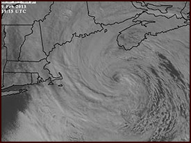
This is another satellite shot of the Blizzard of 2013 forming an eye as it pulls away out to sea.
MILLER A PATTERNS
Most of the time, blizzards that impact Western Massachusetts take the form of a Nor’easter that takes the shape of a Miller A pattern. Miller A storms have their origins down in the Gulf of Mexico. Such storms typically tap the abundant Gulf moisture, and then push east over to the Carolina coast. From there, the storm picks up additional energy and moisture from the Atlantic Ocean and warm Gulf Stream, and proceeds to hook more north-northeasterly up towards southeastern New England. As it does this, it deepens and intensifies the whole way, undergoing a process called cyclogenesis. If this intensification reaches and/or exceeds a drop of 24 millibars of pressure within 24 hours, it is called “bombogenesis”. These Nor’easters can evolve into blizzards when conditions align.
MILLER B PATTERNS
Blizzards can also form from a Miller B pattern. This pattern features a powerful low that pushes up from the center of the country into the Ohio Valley or into Pennsylvania. At this stage, the original low beings to lose some of its strength, and transfers its energy to the Mid-Atlantic region and re-develops off of the DelMarVa Peninsula or New Jersey coast. If the system develops fast enough, and combines with some upstream blocking, it’s possible for a blizzard to develop, though they typically result from the Miller A pattern.
BLIZZARD DEFINITION
Certain elements have to come together for a snowstorm to be classified as a blizzard, yet the definition is still a little loose.
The definition is that a storm must feature blowing snow with sustained OR gusty winds of 35mph or greater, with reduced visibilities down to a ¼ mile or less for a contiguous 3-hour period. In other words, winds can be sustained at 35mph, OR frequently gust to 35mph. And, it doesn’t have to be actively snowing. Even though just about all Blizzard Warnings in Western Mass are issued for active snowstorms, many Blizzard Warnings can be issued for what is called a “ground blizzard”. These are often seen in the central part of the United States after a snowstorm has passed, and Arctic winds have blown through the area.
BLIZZARD OF ’78
The Blizzard of ’78 is the most infamous New England blizzard in Massachusetts history, though there have been others, and recently, the Blizzard of 2013 dumped 18-40” of snow in Western Mass, Connecticut, and Rhode Island.