
All we heard about last year was El Nino, El Nino, El Nino. It is officially tied for first for the strongest El Nino on record (146 years and counting). It’s sister was the 1997-1998 El Nino. Now it appears we are heading into a La Nina event, which is a reversal of a teleconnection called “ENSO”. Teleconnections are large scale dipole weather patterns (“dipole” means two extremes or ends of a spectrum). ENSO stands for “El Nino Southern Oscillation”. It’s a bit confusing, but essentially there are two main components that form the ENSO teleconnection – one is atmospheric, and the other oceanic. The first has to do with atmospheric air pressure at the sea’s surface (that’s the “Southern Oscillation” piece), and the other has to do with the SSTs, or sea surface temperatures (that’s the “El Nino/La Nina” piece).
Before we get into what El Nino and La Nina are, it would be prudent to describe what the “normal” pattern is when it comes to sea surface temperatures, and sea level air pressures in the equatorial Pacific Ocean.
NEUTRAL PHASE OF ENSO
The neutral phase between El Nino and La Nina is an atmospheric/oceanic configuration whereby higher pressures exist in the eastern equatorial Pacific near Ecuador in South America, and lower pressures exist in the western equatorial Pacific near Australia and Polynesia. Correspondingly, this results in drier weather in the eastern Pacific, and wetter weather in the western Pacific. The ocean water in the western Pacific basin is normally very warm, and this warm water releases water vapor into the air above it. Warm air is buoyant and can hold more moisture than cooler air, and so it rises, produces thunderstorms, and it rains out over this region. I believe there is some correlation of this normal wet pattern to the summer monsoons you are hear about in India and points east into southeast Asia.

An atmospheric flow pattern sets up where air rises in the west, condenses and rains, while remaining air diverges to the east high up in the atmosphere, which reaches the eastern Pacific, and sinks towards sea level. This sinking, compressing and drying air fosters high pressure in the eastern Pacific. At the surface the cycle completes as easterlies blow west towards Australia, which helps to confine the warmer ocean water in the western Pacific where the cycle beings again.
The normal easterly trade winds are a result of this pressure difference between and east and west. Remember that wind is created as a result of air traveling from higher to lower pressure, so with high pressure in the east and low pressure in the west, air travels from east to west, a/k/a “easterlies”.
EL NINO/NEGATIVE PHASE OF ENSO
An El Nino event forms when this normal setup breaks down due to a weakening of the easterly trade winds that serve to confine warmer ocean temperatures to the western Pacific. When these winds weaken, warmer water at the surface is allowed to spread eastward all the way to the northwest coast of South America. When this happens, the atmospheric pressure relationship reverses, as low pressure forms over the eastern Pacific, giving rise to humid air and thunderstorms there. In the meantime, cooler water upwells to the east of Australia, and higher atmospheric pressures set up in that region, which can lead to droughts there. The warmer and more moist air in the eastern Pacific tends to cause warmer Winters for us in New England as warmer-than-normal air invades the southern and eastern United States, which is what we saw transpire in the Winter of 2015-2016.
LA NINA/POSITIVE PHASE OF ENSO
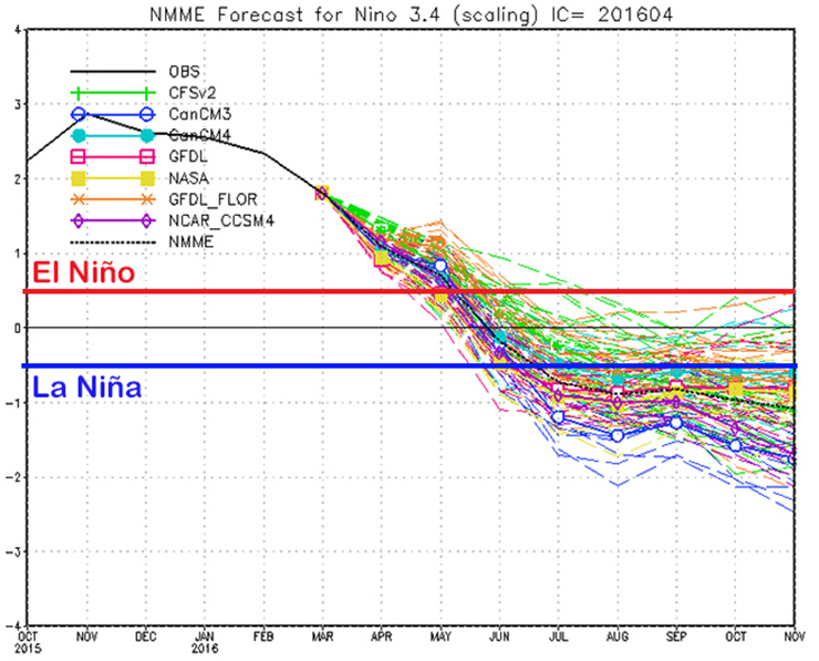
Let’s refer back to the normal configuration – cooler ocean waters in the eastern Pacific, strong easterlies, and warmer ocean waters in the western Pacific. When the easterlies strengthen even more, ocean currents along the northwest South American coast consequently push north/northwesterly along the coastline towards the Equator. And as we now known, stronger easterlies push cooler surface water to the west. When this happens, the surface ocean water near Ecuador that was displaced north and west, is replaced from below by upwelling, which brings colder and more nutrient-rich ocean waters to the surface. This is what happens during a La Nina event, and as you can see in the sea surface temperature anomaly graph, it looks like we may be moving into a weak to moderate La Nina by the time the August to October period arrives… just in time for the Atlantic Hurricane season.

But what does all this mean to our sensible weather here in New England? There are two impacts on our region due to a La Nina event. The first impact is more “rogue” in the form of unpredictable and rare tropical cyclone landfalls in New England, and the second impact has more to do with our daily and seasonal weather.
LANDFALLING TROPICAL SYSTEMS ON THE EAST COAST AND NEW ENGLAND
The first part of our answer has to do with how La Nina episodes affect the North Atlantic Ocean, east of the Lesser Antilles islands, and west of northwestern Africa. It is this section of the North Atlantic (north of the Equator) where tropical systems are born, and travel westward with potential landfalling impacts for the U.S.
Hurricanes and tropical systems thrive and develop rapidly when there is a combination of very warm sea surface temperatures, and little to no large-scale wind shear in the upper levels (wind shear refers to a change in wind speed or direction as your rise from the Earth’s surface to about 40,000 feet in the sky). The warm sea surface temps provide fuel (warm, humid, and buoyant air) for thunderstorm and low pressure development, and low wind shear allows the storm to develop rapidly with increasing winds. Hurricanes are heat engines, and moderate to high wind shear impedes their development or downright destroys them.
We know that in a La Nina event, the region of surface ocean water just west of the Ecuadorian coastline cools rapidly. This causes dry conditions, and high pressure to form. This large-scale stable atmosphere translates eastward into the Atlantic basin, causing large scale areas of little to no wind shear. Due to La Nina’s presence, as waves of low pressure pass westward off of Sub-Saharan Africa into the eastern Atlantic Ocean, and encounter warm water and low wind shear, we tend to have more active tropical development during La Nina events in the Atlantic. Now, of course there are exceptions to every weather rule that exists, but we have to be watchful of the Atlantic Ocean for tropical development this Summer, and especially into early Autumn as La Nina strengthens.
So now that we’ve discussed the impact of La Nina on Atlantic tropical systems, and their potential impact on New England, what about our every day weather impacts here? Below I will focus first on Summer, and lastly on Winter.
LA NINA’S IMPACT ON NEW ENGLAND SUMMERS
Historically, La Ninas that come on after El Nino events tend to raise temperatures above normal in the northern third of the U.S. Combined with the current waning El Nino, this could allow for some hotter temperatures during the late Spring and Summer of 2016, as compared to the last two summers. Whenever you have substantial surface heating, inevitably more humid air will work in from the South during a New England summer, setting up the potential for severe weather outbreaks in the region. Of course, there are many other factors that play into the daily weather we experience here, but it appears it’s more likely than not we’ll have at least a normal Summer in terms of temperature.
But what about Winter? Glad you asked!
LA NINA IMPACT ON NEW ENGLAND WINTERS
La Nina’s strongest effects are felt in the Autumn and Winter months in the United States. The main big-picture weather driver with a La Nina Winter is the positioning of a large, blocking high pressure system somewhere in the northeast Pacific Ocean, south of Alaska.

This ridge pulls the subtropical jet stream (the “moist one”, a/k/a “The Southern Jet/Branch”) farther north than it otherwise would be, causing it to bring lots of precipitation to the Northwest U.S. After the subtropical jet passes south of the blocking ridge into the Northwest U.S., it then dives southeast and exits at various locations along the east coast.
Meanwhile, the polar jet stream (the “cold one”, a/k/a “The Northern Jet/Branch”) has nowhere to go but to the north of the blocking high pressure system. This sends it into British Columbia, and then it dives south and southeast into the United States, bringing cold weather outbreaks from Canada into the northern third of the country. The main impact of this cold is felt in the northwest and northern Plains. However, depending on other teleconnections (i.e. large scale patterns), we can get cold outbreaks in New England, too.
There are other factors at play, too. With less thunderstorm activity in the eastern Pacific, this results in a weaker subtropical jet stream, which means a more meridional (i.e. North-South) flow in the U.S. This buckled jet stream can bring moisture up to New England to mix with cold outbreaks to produce snowstorms.
CONCLUSION
Given the upcoming La Nina event, it is more likely than not that we will have a snowier Winter than 2015-2016. However, it should be noted that with one exception, neutral phase ENSO periods produce the bigger Winters here in New England, which includes the memorable Winter seasons of ‘92-‘93, ‘93-‘94, ‘12-‘13, ‘13-‘14, and ‘14-‘15.
The one exception?
The Winter of ‘95-’96, which was the biggest winter on record in western Mass! It occurred during a mild La Nina event! This coming La Nina looks to be more of a moderate event, so we shall see how it all transpires.
And remember that there was a strong La Nina in place when the Halloween Nor’easter hit on October 29, 2011. In other words, La Nina can act as a wintry volleyball set, and if other teleconnections play along, it can lead to wintry spikes of snow, ice and cold in New England.
In closing, while there are other large-scale patterns that will play into next Winter’s weather, La Nina is a big player for sure.
I will be watchful and keep you updated! Thanks for reading my book ;-)